GEO 583 Internet Mapping and Distributed GIServices
![]()
![]()
![]()
Unit NINE (Session One):
![]()
Wireless Mobile GIS and telecommunication
![]()
Group Project Progress Report:
Group Project Progress Report:
Group 1: The SD Camping Guide
Team members: Jesus A. Tamayo, Caleb Bombaci, Richard Caslow.
Group 2: Pups Who Brunch - San Diego
Team member: Melanie Lopez (Coordinator), Haihong Huang, Fali Field
http://map.sdsu.edu/mobilegis/
Definition: What is Mobile GIS?
Mobile GIS is an integrated software/hardware framework for the access of geospatial data and services through mobile devices via wired or wireless networks. (Tsou, 2004, p. 153).
(Tsou, M.H. (2004). Integrated Mobile GIS and Wireless Internet Map Servers for Environmental Monitoring and Management, (the Special Issue on Mobile Mapping and Geographic Information Systems) in Cartography and Geographic Information Science. 31(3), pp. 153-165.)
(in Blackboard Reading material)
![]()
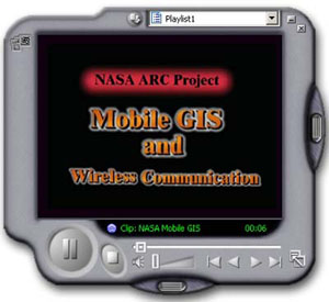
Mobile GIS demo:
NASA REASoN Mobile GIS demo movies:
MPEG Version (320x240 resolution),
WMV Version (640x480 resolution)
![]()
Mobile GIS are an integrated technological framework for the access of geospatial data and location-based services (LBS)through mobile devices, such as Pocket PCs, Personal Digital Assistants (PDA), or smart cellular phones. With the advancement and convergence of GPS, Internet, and wireless communication technologies, mobile GIS have a great potential to play an important role in field data acquisition and validation (Pundt 2002) and emergency vehicle routing services (Derekenaris et al. 2001). Today, there are more and more mobile GIS applications established by private companies (Crisp 2003), government agencies, and academic research institutes. (cited from Tsou, M.H. (2004). Integrated Mobile GIS and Wireless Internet Map Servers for Environmental Monitoring and Management, (the Special Issue on Mobile Mapping and Geographic Information Systems) in Cartography and Geographic Information Science. 31(3), pp. 153-165.)
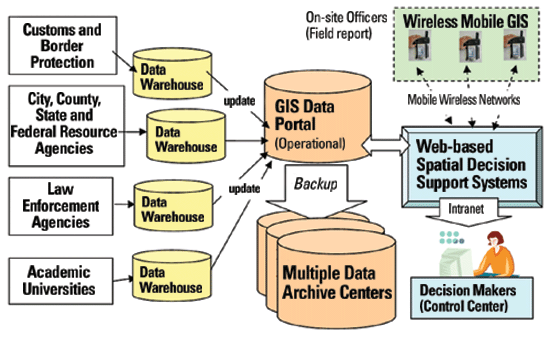
The main users of mobile GIS are the field workers and consumers of location-based services (Peng and Tsou 2003). For example, an environmental scientist in a national park can use GPS and mobile GIS devices to validate, add or delete the locations of sensitive plants. A shopper can use a smart phone to locate the nearby shopping mall and create the shortest routing path for the navigation purpose. A police officer can use a Pocket PC to report a traffic accident with the accurate geospatial locations and sends the report directly to the control and command center via wireless networks. These mobile GIS applications utilize different types of technologies, software packages, and hardware devices. Sometime they are also introduced by different names, such as Field Based GIS (Pundt and Brinkkotter-Runde 2000), Location Based Services (LBS) (OGC 2003a; Peng and Tsou 2003), and wireless GIS mapping (Xue et al. 2002) and Telecartography (Gartner 2003). Actually, the differences in these names reflect the complicated nature of mobile GIS applications and the dramatically progress of related GIS/telecommunication technologies. The following paragraph will provide a clear definition of “mobile GIS”, then it will explain the differences between these terminologies used in different mobile GIS applications. ( Tsou, M.H. (2004))
This paper will define the term, Mobile GIS, as an integrated software/hardware framework for the access of geospatial data and services through mobile devices via wireline or wireless networks. There are two major application areas of mobile GIS: Field Based GIS and Location Based Services. Field Based GIS focuses on the GIS data collection, validation and update in the field, such as adding a new point data or change the attribute tables on an existing GIS dataset. Location Based Services focuses on business-oriented location management functions, such as navigation, street routing, finding a specific location, tracking a vehicle, etc (Jagoes 2002; OGC 2003b). The major differences between the Field Based GIS and LBS are the data editing capabilities. Most Field Based GIS will need to edit or change the original GIS data or modify their attributes. LBS rarely change original GIS data but simply use them as the background or reference maps for navigation or tracking purposes. Wireless GIS mapping is also one subcategory of mobile GIS which focus on the wireless networking capability of mobile GIS. ( Tsou, M.H. (2004))
1.1 The Architecture of Mobile GIS
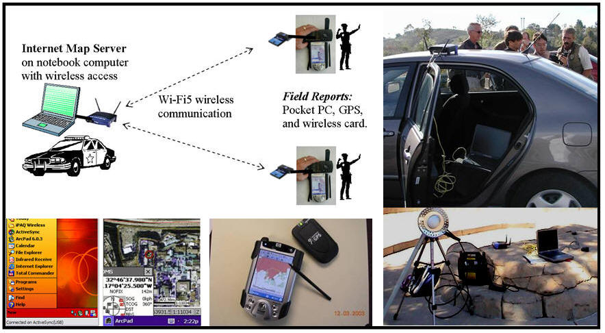
The architecture of mobile GIS is very similar to the Internet GIS. It follows the concepts of client/server architecture in traditional Internet GIS applications. The client-side mobile GIS components are the end-user machines which can display maps or provide analytical results of GIS operations. The server-side components provide comprehensive geospatial data and GIS operations based on the requested from the client-side components. Between the client and server, there are various types of communication networks (such as wired cable connections or wireless communications) to facilitate the exchanges of geodata and services between clients and servers. Figure 1 illustrates the six basic components of mobile GIS:
positioning systems,
mobile GIS receivers,
mobile GIS software,
data synchronization/wireless communication component,
geospatial data, and
GIS content servers.
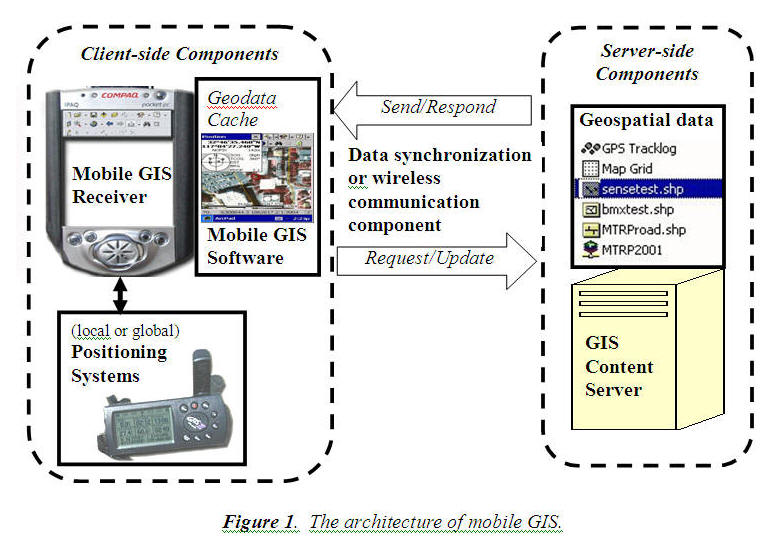
| Positioning Systems refer to the devices which
can provide georeferenced coordinate information (X, Y, and Z-elevation) to
mobile GIS receivers. There are two major systems, local positioning
systems and global positioning systems (GPS). Local positioning
systems rely on triangulation of the radio signals or cellular phone signals
from multiple base stations in order to calculate the position of these
devices. GPS use satellite signals to calculate the position of the GPS
units. Sometime, mobile GIS applications may require both types of
positioning systems in urban areas for generating better results.
|
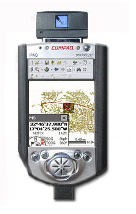
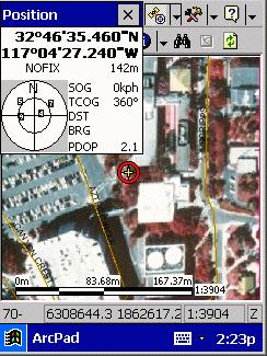
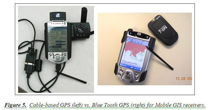
| Mobile GIS receivers are small-sized computers or terminals which can display maps and locational information for end-users. The hardware components of mobile GIS receivers include CPU, memory, storage devices, input/output connections, and display (screen) functions. Pocket PC, smart phone, tablet PC or PDAs are the most popular mobile GIS receivers. Sometime, notebook computers can become a mobile GIS receiver if they get connected with GPS and other mobile GIS components. However, most mobile GIS receivers require a very small size hardware device for their portability. The major differences between small mobile GIS receivers and traditional personal computer are smaller screen resolutions (240x300), limited storage space, and slower CPU speed (Wintges 2003). Some high-end mobile GIS receivers equipped with wireless communication devices which can be used for data exchanges and telecommunications between the receivers and the content servers. Otherwise, the mobile GIS receivers will rely on serial cables or USB cable to transfer data between the content servers and the handhold devices. |
| Smart phones: http://www.microsoft.com/windowsmobile/smartphone/default.mspx | |
| Different between Smart phone and Pocket PC. http://www.microsoft.com/windowsmobile/about/faq.mspx |
| Mobile GIS software refers to the specialized GIS software packages for mobile GIS applications. Because of the limitations of mobile GIS receivers (smaller display units, limited storages, etc.), the design of mobile GIS software will need to focus on specific GIS operations (geocoding, address matching, spatial search, routing services, map display, etc.) rather than huge packages of comprehensive GIS functions. For example, the major design of LBS software is quite different from the functions provided in field-based GIS packages. Most mobile GIS software packages are lightweight, customizable, and can cope with positional systems (such as GPS tracking functions). Different mobile GIS software may require different operating systems (such as Windows CE or Palm OS). |
Windows Mobile: http://www.microsoft.com/windowsmobile/default.mspx
Palm: http://www.palm.com/us/ , http://www.palmsource.com/index.html
Palm OS: http://www.palmsource.com/palmos/
BlackBerry: http://www.blackberry.com/
IPhone: http://www.apple.com/iphone/
Android: http://code.google.com/android/
| Geospatial data are customized GIS layers or remotely sensed imagery for mobile GIS applications. Because of the limited storage space in mobile GIS receivers, most GIS data need to be compressed or clipped out from the original formats. Usually, the mobile GIS receivers will store the geospatial data in geodata cache, which is a temporary GIS storage space or a flash memory card. The customized dataset are downloaded and synchronized from the GIS content servers. One alternative approach is to utilize the wireless communication to access the large-size of GIS layers and remotely sensed imagery from the content server directly. The advantage of direct wireless access is that mobile GIS users can access most updated geospatial information from the content server without worrying about the complicated data synchronization process between the mobile GIS receivers and the content servers. |
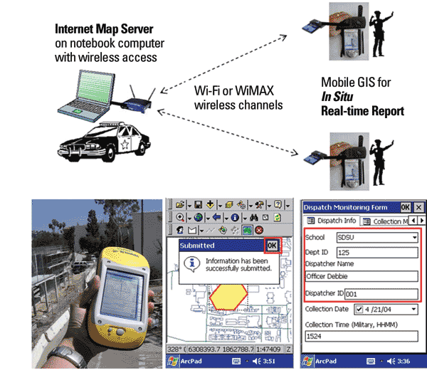
| Data synchronization/wireless communication component are the communication mechanism to link the mobile GIS receivers and the GIS content servers. The linkages could be real-time wireless communication (via Wi-Fi or cellular phone signals) or cable-based data synchronization (via USB or serial ports). Both mechanisms should provide two way communications. For cable-based connection, the GIS content servers can send geodata to the receivers (stored in geodata cache) and the receiver can upload updated geodata back to the content server. For wireless communication, the mobile GIS receivers can request a specific service or maps from the GIS content server, and the server will respond the request by sending the new map to the receiver. To facilitate the two way communications, several middleware or data synchronization software (such as Microsoft ActiveSync or Web Services) are required for mobile GIS applications. If both mobile receivers and GIS content servers have networking capabilities, the Internet can become a very effective communication channels for mobile GIS applications. |
| GIS content servers are stand-alone GIS workstations or web-based servers which can provide geospatial data or map services for mobile GIS receivers. Most cable-based mobile GIS receiver will use a stand-alone GIS workstation for the content servers. Wireless-based mobile GIS receivers may require advanced web servers or wireless Internet map servers for accessing geospatial data. Sometime, one mobile GIS receiver can access multiple web-based servers at the same time to integrate multiple GIS layers. One GIS content server can also provide data and services to multiple mobile GIS receivers at once. |
Figure 1 demonstrates a very generic mobile GIS architecture. Different mobile GIS applications may have unique settings or additional components. For example, landscape architects may simply use a remotely sensed imagery as a background to draw a preliminary design of tree lines without the GPS component. Some sensitive data or classified mobile GIS operations may become stand-alone units without any external communication mechanisms (for security reason).
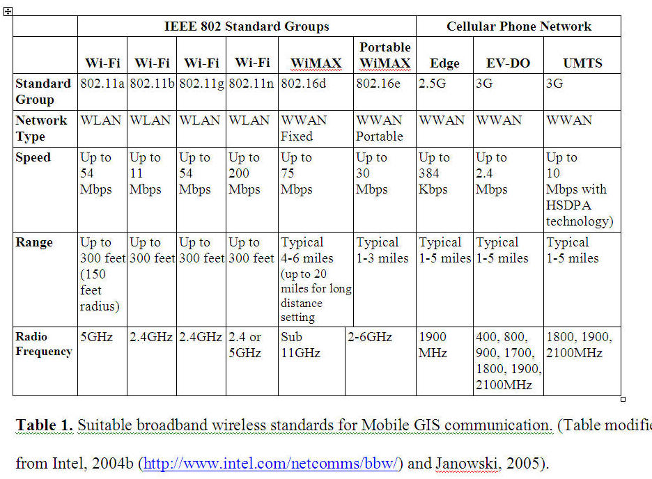
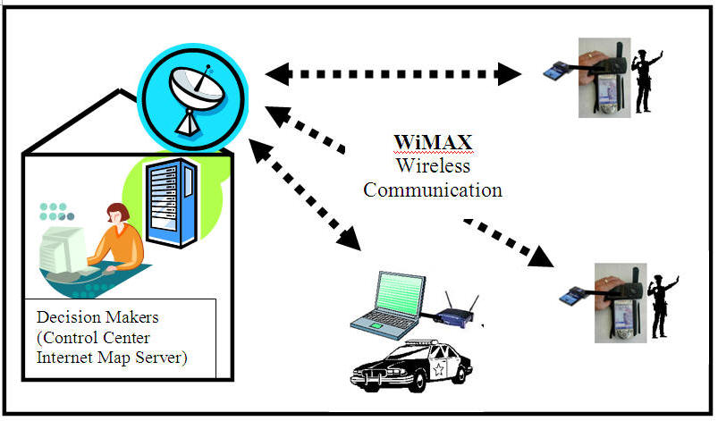
WiMAX is an emerging IEEE 802.16 standard for broadband wireless wide area network (WWAN) or Metropolitan area network (MAN) applications. WiMAX can provide a larger coverage of service area than Wi-Fi. Its communication signals can cover 4-6 miles range (up to 20 miles for the long distance setting). WiMAX can provide broadband to areas that do not have cable or DSL services. Presently, WiMAX includes two steps of the IEEE 802.16 technology. The IEEE 802.16d is the first step which will be used to specify large area wireless communication via outdoor antennas in a fixed location. A fixed WiMAX service can provide up to 75 Mbps speed with Sub 11Ghz radio frequency. The IEEE 802.16e will be the next step (under development), used to specify portable wireless hardware for mobile WiMAX services. The new mobile WiMAX can provide roaming capability and enabling more persistent connectivity within a service area (Intel, 2004a).
Table 1 illustrates the major wireless standards which are suitable for mobile GIS with Collaborative GIS architectures. Note that the two major wireless systems (cellular networks and IEEE 802 groups) both focus on the development of next generation broadband wireless communication coverage. However, the two systems are not currently compatible with each other due to the different radio frequency. From a GIS user perspective, it is very difficult to switch seamlessly between Wi-Fi and EVDO wireless network while working in the field or traveling. Actually, the two systems may have to compete with each other in the future because the new Voice-IP technology will enable Wi-Fi or WiMAX to provide wireless phone services over a large area.
(cited from Tsou, M.H. (In Press). Bridging the Gap: Connecting Internet-based Spatial Decision Support Systems to the Field-based Personnel with Real time Wireless Mobile GIS applications. Book chapter in Collaborative Geographic Information Systems (Edited by Shivanand Balram and Suzana Dragicevic). Idea Group, Inc.
(Level 1)
(Level 2).
YouTube Video: https://www.youtube.com/watch?v=g7qF_BALk0s
WiMAX: http://www.wimaxforum.org/home/
INTEL: http://www.intel.com/technology/wimax/
Why WiMAX is not successful in U.S. Market?
What's the new 4th Generation of Wireless network?
LTE (3GPP Long Term Evolution)
Peak download rates up to 299.6 Mbit/s and upload rates up to 75.4 Mbit/s depending on the user equipment category(with 4x4 antennas using 20 MHz of spectrum).
http://en.wikipedia.org/wiki/3GPP_Long_Term_Evolution
![]()
NASA REASoN project:
http://geoinfo.sdsu.edu/reason
![]()
Unit TEN (Session Two):
![]()
On-line Forum Discussion
Blackboard URL: https://blackboard.sdsu.edu/
![]()
Introduction to the Android Platform:
https://www.youtube.com/watch?v=1FJHYqE0RDg
http://code.google.com/android/
Android is a software stack for mobile devices that includes an operating system, middleware and key applications. The Android SDK provides the tools and APIs necessary to begin developing applications on the Android platform using the Java programming language.
| Application framework enabling reuse and replacement of components | |
| Dalvik virtual machine optimized for mobile devices | |
| Integrated browser based on the open source WebKit engine | |
| Optimized graphics powered by a custom 2D graphics library; 3D graphics based on the OpenGL ES 1.0 specification (hardware acceleration optional) | |
| SQLite for structured data storage | |
| Media support for common audio, video, and still image formats (MPEG4, H.264, MP3, AAC, AMR, JPG, PNG, GIF) | |
| GSM Telephony (hardware dependent) | |
| Bluetooth, EDGE, 3G, and WiFi (hardware dependent) | |
| Camera, GPS, compass, and accelerometer (hardware dependent) | |
| Rich development environment including a device emulator, tools for debugging, memory and performance profiling, and a plugin for the Eclipse IDE |
Android relies on Linux version 2.6 for core system services such as security, memory management, process management, network stack, and driver model. The kernel also acts as an abstraction layer between the hardware and the rest of the software stack.
How to Install the Android SDK on Windows XP

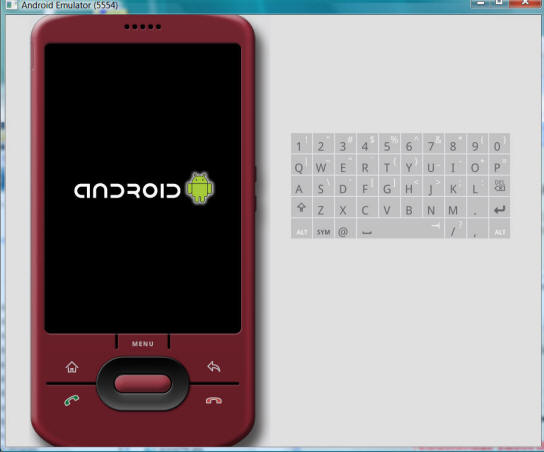
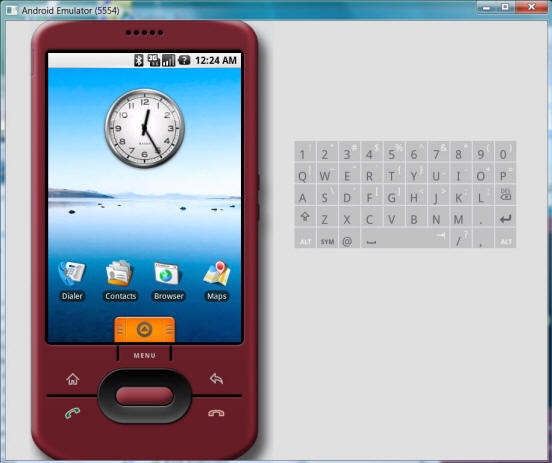
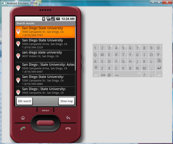
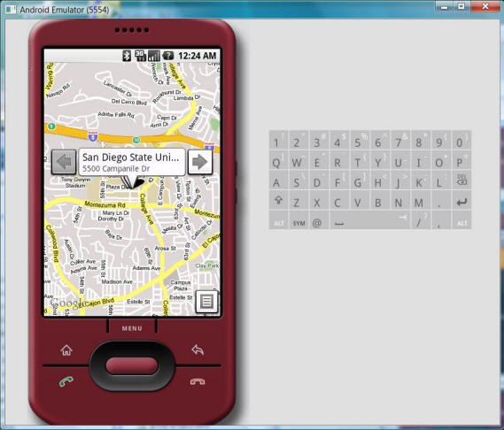
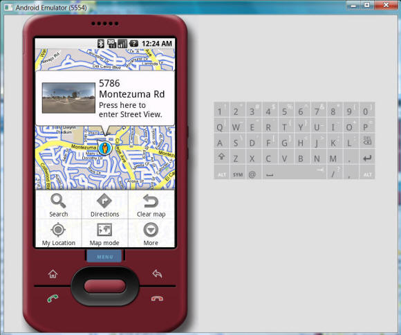
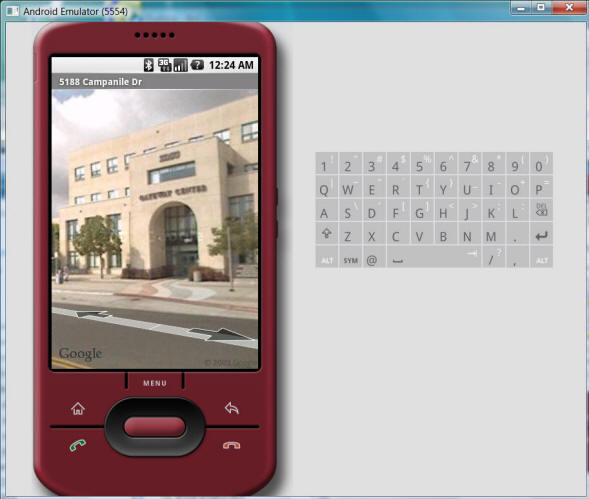
Android Emulator (provided by the SDK)
![]()
Additional Information (Optional contents)
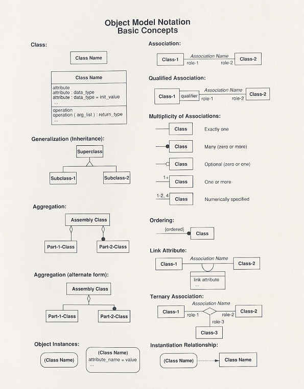
Object-Oriented Modeling
![]()
(Source: Rumbaugh, et.al, 1991, Object-Oriented Modeling and Design, Prentice Hall)
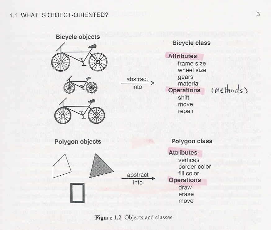
Object-oriented concepts originate from object-oriented languages. The original object language was "Simula" developed in Norway in 1960s (Taylor, 1992). The language was designed to simulate our real world interaction to resolve complex simulation problems. Inspired by Simula, Smalltalk become the initial completed object-oriented language in the 1970s. This language was developed by Alan Kay and Adele Goldberg at Xerox's Palo Alto Research Center ( PARC ). It was regarded as the first object-oriented language by the general public. Smalltalk leads to the addition of object-oriented features to many traditional procedure languages such as C and Pascal. Object-oriented approaches dramatically change the traditional concepts and the structure of software and programming language. Now, almost all of the next generation software adopt the object-oriented concepts and approaches as their core for development.
The most important contribution of the object-oriented technology is to provide an efficient way to make software constructed by standard and reusable components (Taylor, 1993). It allows different parts of the software to be developed simultaneously and easy to maintain, and modify when necessary. It also improves the reliability of systems and software. Integrating information and procedures in the database will reduce unnecessary coding in programming and make the information system more useful and flexible.
According to the definition of object-oriented concepts by Taylor in his book (1993), there are three major concepts in object-oriented approaches: Objects, Messages and Classes.
Objects
Objects correspond to real world entities such as physical things like cars or people. The entity encapsulates related procedures (methods) and data (variables). Objects protect their data by the way of encapsulation. Only the methods of the object can access its data, which is called "information hiding". The method of encapsulation can prevent a program from being interfered with by other unrelated change or the data being modified by the unnoticed programming mistake. The modification or update of an object will not affect the other objects and applications. Objects can connect with other objects by containing other objects' identification variables. Thus, many objects can be organized and grouped as a hierarchic structure. The structure of objects is similar to our real world.
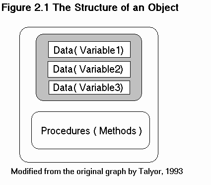
Messages
The communication between objects depends on "messages" or "requests". Messages require services of other objects. The structure of messages includes three parts: receiver, method, and parameter. So the update or change of information does not need to deal with internal data structure or formats. The modification of objects is easier and safer. Moreover, some methods can have different meanings depending on which object is used. This is called polymorphism. It can simplify complex systems and reduce the use of case statements and improve the efficiency of the systems.
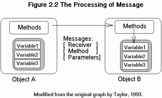
Classes
A class is a template for defining types of objects. An object is an instance of a class. Classes also contain class methods such as constructors and destructors which can create a new instance of objects, or destroy objects. Classes share properties by using a mechanism called "inheritance". Some parts of the data and methods of superclass will inherit their subclass according to the relationship between the superclass and the subclass. Superclasses can "broadcast" their changes to their subclasses, as the domino effect, which makes it easy to modify software. It also handles the exception case which can be redefined as a new object at a lower level. In a nutshell, class hierarchies provide us with a natural organization of objects.
The best thing in object-oriented approach is that we can encapsulate data and operations into object frameworks (Encapsulation). It can avoid the damage of important data due to an accident or unintentional change by modifying systems or programming mistakes. Spatial data need to be updated frequently and be transformed to many different formats. They need to be protected from external involvement. Another advantage is the reuse of components of objects. As for applications and models, particularly in GIS, there are many different applications and models being developed now. Object-oriented methods will encourage people to establish application models and improve them. Thus geographical knowledge can be accumulated and applied.
(Source: Rumbaugh, et.al, 1991, Object-Oriented Modeling and Design, Prentice Hall)
Unified Modeling Language (UML)
(developed by Booch, Rumbaugh, & Jacobson.)
The Unified Modeling Language (UML) is a object-oriented modeling language and specification for specifying and constructing distributed software architecture. Prior to UML, there was no clearly leading Object-Oriented (OO) modeling language for deploying a distributed software architecture. Three major OO languages, Object Modeling Technique (OMT) (Rumbaugh, et al, 1991), Object-Oriented System Engineering (OOSE) (Jacobson, et al, 1992), and Booch’93 (Booch, 1994), are well-known models adopted by many OO projects. In general, OOSE is a use-case oriented approach that provides excellent support for business engineering and requirements analysis. OMT and its successor, OMT-2, are especially designed for analysis and data-intensive information systems. Booch ’93 is particularly expressive for the design and construction of engineering-intensive projects. UML fused the concepts of Booch, OMT, and OOSE into a single, common, and widely usable modeling language. UML promotes a development process that is "use-case driven, architecture-centric, and iterative and incremental" (Booch, Rumbaugh, and Jacobson, 1998).
Related Links:
|
UML Resource Center (Rational Software) http://www.rational.com/uml/index.jsp | |
|
OMG UML Resource Page: http://www.omg.org/technology/uml/index.htm |
UML Use-Case Model
A GIS user, Mike, plans a trip from Boulder, Colorado to Utah’s Arches National Park. He needs to acquire map information and make a hotel reservation for two nights in the city of Moab, Utah. This scenario demonstrates four advantages of distributed GIServices: on-line, multi-layer mapping; data integration; on-line transactions; and smart information searching.
GIS tasks:
The scenario performs four major GIS tasks (Figure 5-9):
|
Display maps | |
|
Create a shortest route | |
|
Printout maps | |
|
Make a hotel reservation |
In this scenario, there are three major human actors. Mike, a GIS user, wants to accomplish the trip plan. Tina, a map designer, designs appropriate symbols and layouts for several national park maps, including the Arches National Park trails and puts them into a GIS server for on-line access. In fact, there should be other map designers for highway roads, city roads, and hotel locations. Since the map designers’ activities are similar, this scenario will only identify Tina, as a representative map designer. Kevin, the hotel reservation manager, will provide the hotel reservation information (price, room availability, etc.) and accept the reservation from Mike. Beside the three human actors, several software agents will be mentioned later.
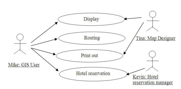
The travel plan Use-Case Model in UML.
More information: http://www.agilemodeling.com/style/useCaseDiagram.htm#_Toc314153
![]()
Object-Oriented Databases vs. Relational Databases
1. Relational Database Management Systems (RDBMS): (on-line definition by Webopedia http://www.webopedia.com/)
RDBMS is a type of database management system (DBMS) that stores data in the form of related tables. Relational databases are powerful because they require few assumptions about how data is related or how it will be extracted from the database. As a result, the same database can be viewed in many different ways. An important feature of relational systems is that a single database can be spread across several tables. This differs from flat-file databases, in which each database is self-contained in a single table.
A relational database saves all its data in the table format. All data queries and operations are done on the tables themselves or generate another tables for further uses. A table is a set of rows and columns. There are a few characteristics of RDBMS:
| Data is presented as a collection of tables and their relations. | |
| Columns are attributes or fields | |
| Rows ("tuples") represent entities or records | |
| Each record has a set of attributes that taken together as a "Primary key" uniquely identifies each entity. |
2. Object-Oriented Database Management Systems (OODBMS or ODBMS):
When you integrate database capabilities with object programming language capabilities, the result is an ODBMS. An ODBMS makes database objects appear as programming language objects in one or more existing programming languages. The ODBMS extends the language with transparently persistent data, concurrency control, data recovery, associative queries, and other database capabilities. (source: http://www.odbmsfacts.com/articles/object_database_definition.html )
Related Links:
|
Object-Oriented Databases http://www.odbmsfacts.com/ | |
|
Smallworld GIS: An Object-Oriented GIS - Issues and Solutions Arthur Chance, Richard G. Newell & David G. Theriault |
3. SmallWorld Example (Object model vs. Map layers model)
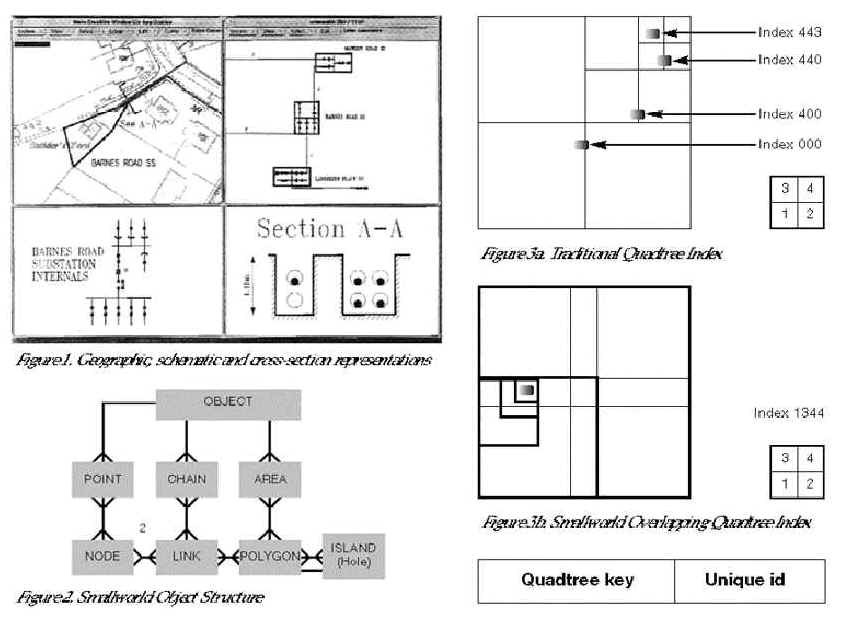
(Source: Smallworld GIS: An Object-Oriented GIS - Issues and Solutions Arthur Chance, Richard G. Newell & David G. Theriault)
4. SmallWorld Internet Application Server (source: Worldwode News, Volume 2 Number 4, p.30., published by SmallWorld Offices).
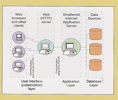
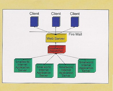
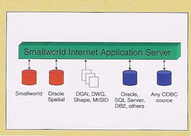
SmallWorld Internet Application Server delivers a complete Internet-enabled geospatial information system. Many other solutions are limited to static maps and simple Query/View/Print applications, while Internet Application Server enables:
REFERENCES:
Booch, G., Rumbaugh, J., & Jacobson I. (1998). The Unified Modeling Language User Guide. Reading, Massachusetts: Addison-Wesley.
ESRI (2000). ArcIMS Installation Guide. ESRI press.
Rumbaugh, J., Blaha, M., Premerlani, W., Eddy, F., & Lorensen, W. (1991). Object-Oriented Modeling and Design. Englewood Cliffs. New Jersey: Prentice-Hall.
Taylor, D. A., 1992, Object-Oriented Information Systems: Planning and Implementation., John Wiley & Sons, Inc., New York.
Taylor, D. A., 1993, Object-Oriented Technology: A Manager's Guide, Addison-Wesley, sixth printing., Workingham, England.
Worboys, M. F., Hearnshaw, H. M., and Maguire, D. J., 1990, Object-oriented data modeling for spatial database. International Journal of Geographical Information Systems, Vol. 4, No. 4, pp. 369-383.
![]()
![]()
![]()
![]()
![]()