GEOG 581: Cartography Design
![]()
![]()
![]()
![]()
![]()
![]()
GeoVisualization
![]()
GIS PLANET 2005 http://www.gisplanet.org/
International Board consists of relevant worldwide representatives from the institutional, industry and user communities.
Group project update
|
Group 1. Visualization of change of population in San Diego County (Ken, Fred, Tod) | |
|
Group 2. Relocation of the San Diego International Airport (Rosanna, Addie, Lauren, and Pillip) | |
|
Group 3. Ecological Fallacy: A Comparative Analysis of Census Block Groups and Census Tracts. (Erica, Ahmed, and Merrilee). | |
|
Group 4. Otay Reservoir Assessment (Jing-Yi, Phillip, and David) | |
|
Group 5. Trails of Yosemite National Park (Asia, Andy, and Jennifer) | |
|
Group 6. Safe mover guide (Matt and Alvaro). |
![]()
GVIS: Facilitating Visual Thinking: search for unknown, real-time interaction with spatial information., and individual control over the map display process (MacEachren, p. 361).
![]()
First level: Feature Identification (Feature ID)
First level: Feature Identification (Feature ID): include both recognition of anticipated features and noticing of unanticipated features. (Visualization should facilitate both). (which one is more interesting?)
Feature ID = pattern-matching model --- scientists (and humans in general) make decisions by matching present situations against a collection of patterns representing past experiences and knowledge.
For example, the 2004 Presidential election in California, San Diego.

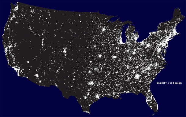
(Image source: http://www.princeton.edu/~rvdb/JAVA/election2004/)
Seeing --> Hypothesis --> Reasoning Why
Space and time are indispensable variables. (help the GVIS). Expanding the dimensions of an indispensable variable will make representating high dimentional data more successful.
3D representation:
2.5 D for temperature vs. 2D (isoline) for temperature.
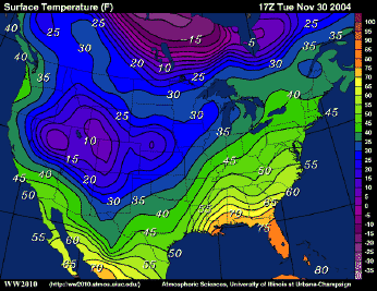

(However, both 2.5D and true 3D display have two problems: hidden areas and scale change (front vs. back).
Possible solution: more interactively change the view angles...
Other cases (to help or affect the feature identification)
Time (temporal changes)
Scale-dependent (small pictures vs. large pictures)
Resolution-dependent (high resolution vs. low resolution).
![]()
Second Level: Find out
the Relationships among features (in space and time)
Feature comparison: looking for relationships in multidimensional data
(compare the population density vs. housing price)
cross-table, row-column, matrix analysis..
(compare the presidential elections between LA vs San Diego)
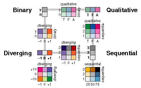
Use orientation or color to facilitate the comparison.
Orientation Examples: http://www.visn-x.net/nx2/21/08.html , http://www.rhodium-consulting.com/node10.html
Color Example: Dr. Cindy Brewer's color scheme: http://www.personal.psu.edu/faculty/c/a/cab38/ColorBrewerBeta.html

![]()
Complex situation: Dynamic Space-Time multidimensional process (STFA): if a problem has both spatial and temporal components, visualization tools that do not take both into account have the potential to do more harm than good.
![]()
Final Step: GVIS for Human Decision Making:
private or public truth?
Private information level: how to judge the quality (truth) of the GVIS display?
|
Data Uncertainty (Quality control) | |
|
See wrong vs. Not seeing (which one is better?) |
Public Level: What is the truth in the context of GVIS?
|
Public presentation and implicit connotation | |
|
GVIS displays are not true or false, only similar or dissimilar. | |
|
realism in scientific representation (realism = truth?) |
What are the future direction for Geovisualization? Any suggestions or topics?
NO CLASS on Thursday.
![]()
![]()
Web-powered by: MAP.SDSU.EDU