GEO 583 Internet Mapping and Distributed GIServices
![]()
![]()
![]()
UNIT TWO (Session One):
The History of Internet and Web Mapping
![]()
GEO 583 Internet Mapping and Distributed GIServices
![]()
![]()
![]()
UNIT TWO (Session One):
The History of Internet and Web Mapping
![]()
Definition of "Internet Mapping" (from Class 2018):
Jesus Tomayo: Internet mapping is using web design skills along with cartographic and map making skills to develop online products.
Caleb Bombaci: The creation of user interface maps in a cloud based system (computers, phones).
Richard Caslow: Using the wide range of data and resources that the Internet offers to make useful and easy to read maps.
Melanie Lopez: Maps + services on the Internet.
Fali Field: Not necessary a physical space/address, but understanding part or whole of internet.
Definition of "Internet Mapping" (from Class 2017):
Nevin Valles: Being able to publically share & analyze spatial data information.
Carl Reed: Internet mapping the display of information pertaining to specific subject on a map.
Adam Russnogle: The use of cloud or distributed services to manipulate spatial data or to create maps.
Farnaz Farhang: Mapping using current information from Internet, live social media data.
Yuko Nakajima: Realtime mapping, public access to improve wellness of society.
Definition of "Internet Mapping" (from Class 2016):
Jessica Dozier: Using services to create maps on the Internet for easy distribution and collaboration.
John Ho: Live data being visualized on websites.
Juan Pablo Moreno: Learning how to provide visualization of location through mapping on a website. It provides a way of communication.
Christine Burris: Creation, publication, & maintenance of maps meant for the Internet (with interactivity).
Hao Zhang: A way of presenting spatio-temporal information for public in order to stay as a platform for interactive services.
Joey Ying Lee: Online mapping which makes maps can contribute by "netizen", and sharing to everyone. (defining netizen...).
Chelsea Obrochta: Using maps to identify and convey particular variables. It's easier for people to see things on a map than just hear about them.
Qinyuan (Rick) Zhang: 1. Be public to everyone, 2. Collecting and presenting data on time (update), 3. Access without local desktop license. 4. Contribution can be anyone (more interactions).
Brandon Hugueley: Visually representing data.
Ardeshir Beheshti: Geospatial data that is connected with online databases.
Thomas Clark: Internet Mapping is useful for various circumstances, such as disasters, & data can be continuously updated.
Mohammad Baghlaf: Internet Mapping is the map the can be active with the users. The map will include specific information that attract the users.
Elias Issa: Scheme Displaying the position of geographic information and making it public to everybody in real-time.
Sean McDowell: Maps that are able to be published online and used by a select user-base.
Andrew Kerr: Any GIS that goes on beyond a single workstation, whether the content be static or dynamics, interactive or non-interactive.
Kenneth Gervais: The applications of Internet resource & communication with imagery and information around the world.
Eduardo Cordova: Using the interconnectivity of the Internet to better process and compile information for practical use.
Matt Stewart: Using different computer programs to analyze and usually show different data across the Internet.
Jeremy Harris: Utilizing various Internet sources to use and create maps to distribute on the Internet.
Jakob Daoust: Internet mapping is a tool used to display data and their locations to be used to gather information by anyone who has access to the Internet.
Definition of "Internet Mapping" (from Class 2015):
Gregory Brown: Providing interactive spatial analysis to populations through mass communication.
Erick Cruz: Maps obtained and created through HTTP protocol.
Albert Herrera: Web Mapping is a way for users to explore maps interactively and for developers to display spatial data or reveal spatial patterns in a user friendly way.
Tim Schempp: The ability to share geographic / temporal data over a wireless medium.
Susie Madruga: Using Internet data & making / utilizing the World Wide Web to map spatial phenomena.
Chunfai (Frankie) Wong: Interact or access information / content through the method of Internet.
Stefany Pickett: Interactive maps with a smart phone (GPS) to locate interest points.
Jay Lambert: Online available mapping and referencing that can often be interactive.
Edward Cormode: Using online data to make a thematic map. While being able to make it publicly or widely accessible and updatable in real time.
DEFINITIONS
INTERNET:
On October 24, 1995, the FNC unanimously passed a resolution defining the term Internet. The Federal Networking Council (FNC) agrees that the following language reflects our definition of the term "Internet".
"Internet" refers to
the global information system that --
(i) is logically linked together by a globally unique address space
based on the Internet Protocol (IP) or its subsequent
extensions/follow-ons;
(ii) is able to support communications using the Transmission Control
Protocol/Internet Protocol (TCP/IP) suite or its subsequent
extensions/follow-ons, and/or other IP-compatible protocols; and
(iii) provides, uses or makes accessible, either publicly or
privately, high level services layered on the communications and
related infrastructure described herein."
WORLD WIDE WEB: (on-line definition by Webopedia http://www.webopedia.com/)
A system of Internet servers that support specially formatted documents. The documents are formatted in a language called HTML (HyperText Markup Language) that supports links to other documents, as well as graphics, audio, and video files. This means you can jump from one document to another simply by clicking on hot spots. Not all Internet servers are part of the World Wide Web. World Wide Web is not synonymous with the Internet.
Intranet:
(on-line definition by Webopedia http://www.webopedia.com/)A network based on TCP/IP protocols (an internet) belonging to an organization, usually a corporation, accessible only by the organization's members, employees, or others with authorization. An intranet's Web sites look and act just like any other Web sites, but the firewall surrounding an intranet fends off unauthorized access.
![]()
The History of Internet Mapping
![]()
DEFINITIONS
There are three different types of "Internet mapping" when people use this term.
1. Provide maps via the Internet or local networks. The Internet becomes a type of media, comparing to papers, CD-ROMs, or transparencies, which are used for disseminating geographical information (maps).
Example: http://www.mapquest.com , http://maps.google.com
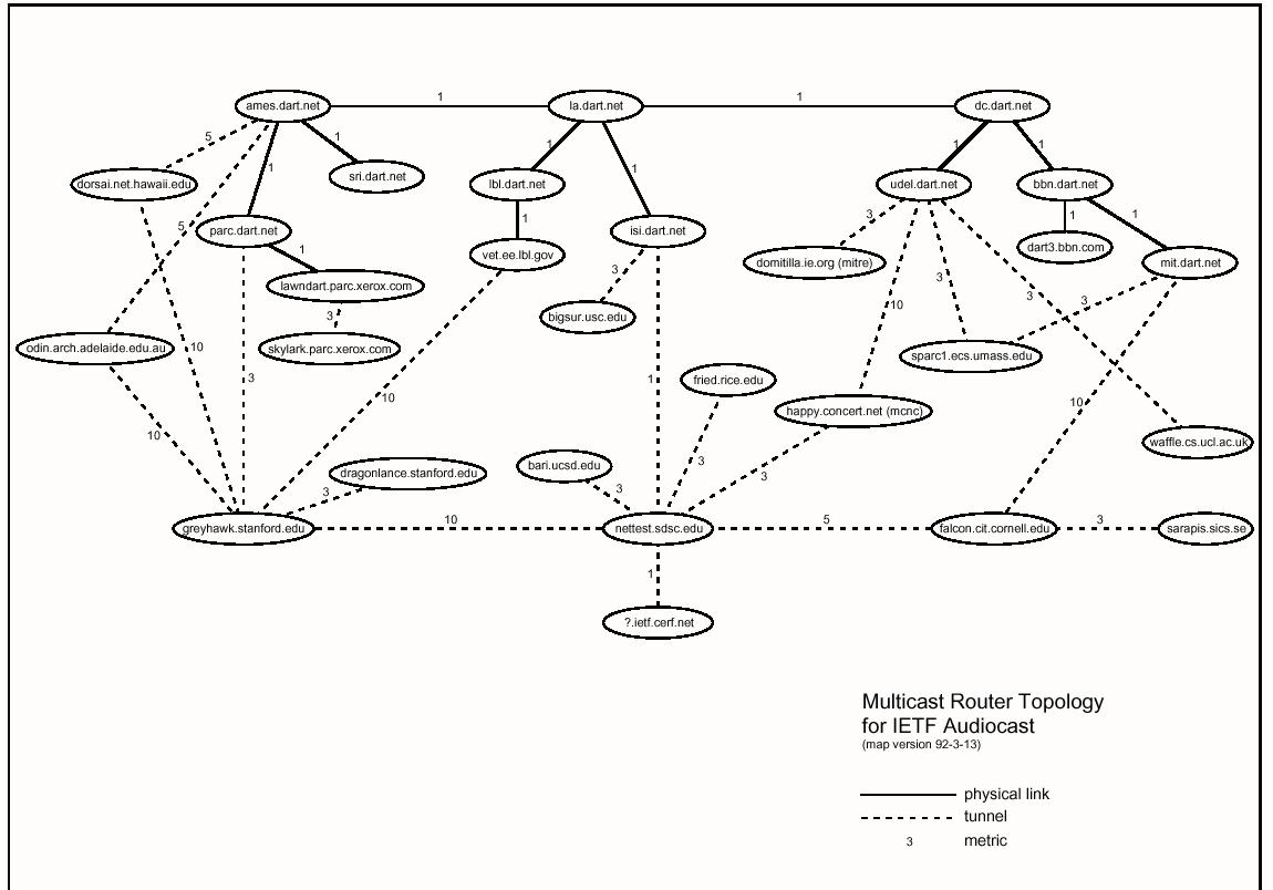
2. Map physical frameworks of the Internet. The Internet becomes a physical object and the map is used for describing the physical network connections and traffics. These types of maps are similar to the transportation maps in traditional geography research, which focus on "nodes", "connections", "hierarchy", and "traffics".
Example: IETF San Diego Tunnels (Network Topology)
3. Map human activities on the Internet. The Internet becomes a virtual environment and the map is used for describing human activities and on-line applications (such as BBS, Chat room, MUD, and Web page access). These types of type are similar to the land use or census maps in traditional geography research, which focus on the "place", "identity", "population", and "human behaviors".
Example: Information Landscape (http://www.cybergeography.org/atlas/info_landscapes.html)
Ming's NSF CDI project: Mapping Ideas from Cyberspace to Realspace: http://mappingideas.sdsu.edu
NOTE: This class (GEOG 583) will mainly focus on the first type of the definitions (i) and will provide basic trainings for Internet Map Servers and related computer technologies. The second and third types of "Internet Mapping" will NOT be emphasized in this class.
The History
Three projects are of primary importance in the development of Internet Mapping and distributed GIServices. They are important because these projects initiated the design of preliminary Internet Mapping frameworks and the adoption of early Internet technologies, such as HTTP and CGI programming. It is important to note in reading this history that a disconnection exists between a focus on services as provided by programs and a focus on data as specified by standards organizations.
The Xerox PARC Map Viewer (http://mapweb.parc.xerox.com/map/) (this viewer is no longer available)
The Xerox PARC Map Viewer is the earliest prototype of distributed GIServices concurrent with the rapid development of the Web. The Map Viewer was developed at Xerox Corporation’s Palo Alto Research Center, as an experiment in providing interactive information retrieval via the World Wide Web (Putz, 1994). The Map Viewer is an interactive Web application, which combines the ability of HTML documents to include graphical images with the ability of HTTP servers to create new documents in response to user input.
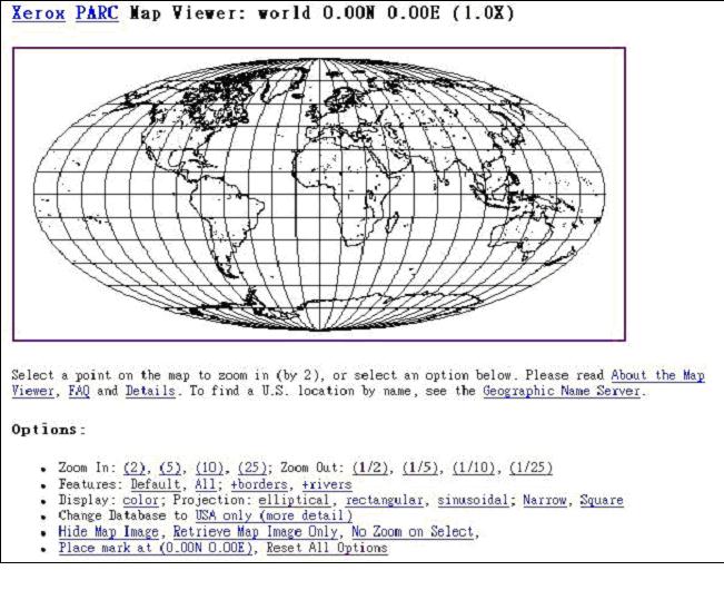
The Map Viewer used a customized server module (a CGI program) written in the PERL scripting language. Map images in GIF format were generated by two separate utility programs on a UNIX server. The first program, MAPWRITER, produced raster map images from two public domain vector map databases. The second program, RASTOGIF, converted raster images to GIF format. In subsequent work, the Xerox Map Viewer was integrated with U.S Gazetteer WWW services created by Plewe (1997), to provide a text-based query function, which is essential for a complete prototype of distributed GIServices.
GRASSLinks (one example: http://ippc2.orst.edu/glinks/ )
GRASSLinks was developed in 1995 by Huse (1995). GRASSLinks was the first fully functional on-line GIService which connects GRASS GIS software (from the US Army Corps of Engineers) and the World Wide Web. GRASS is a grid-based GIS package offering public domain access to environmental and geographical data. The development of GRASSLinks was supported by the Research Program in Environmental Planning and GIS (REGIS) at the University of California at Berkeley. To utilize GRASSLinks, a user only needed a Web browser.
GRASSLinks encouraged cooperation and data sharing between different environmental agencies. In traditional GIS applications, each agency would maintain its own database as well as data obtained from other sources. GRASSLinks introduced a new model of data sharing, where each agency could maintain data which they produced, and access other agencies’ data over the network as needed (Huse, 1995). GRASSLinks could perform many GIS operations, including map display, query, overlay, reclassification, buffering, and area calculation. On-line users can save their works temporarily on the server and retrieve files later. GRASSLinks demonstrates an ideal prototype for high-end distributed GIS functions, and provides an example of the first true on-line GIServices (Plewe, 1997).
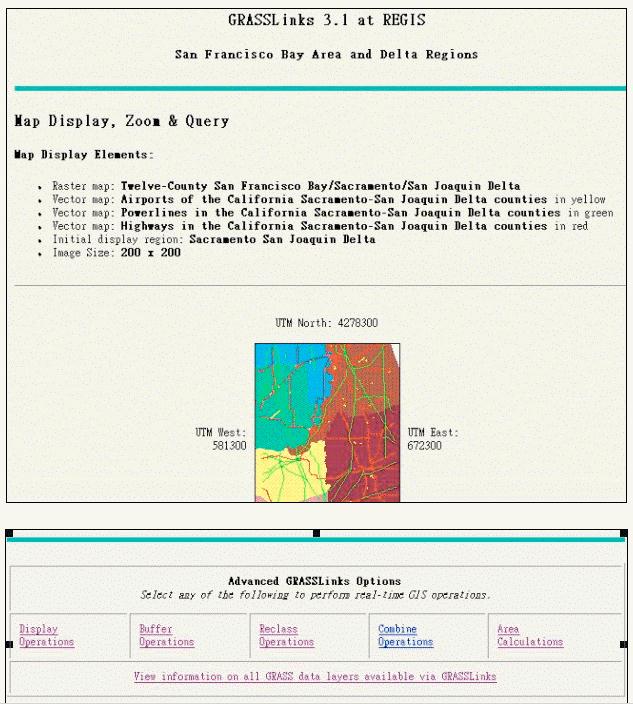
GRASSLinks and its GIS operations.
Alexandria Digital Library Project ( http://www.alexandria.ucsb.edu/ )
(Web client: http://clients.alexandria.ucsb.edu/globetrotter/ )
The Alexandria Digital Library (ADL) Project illustrated a digital library framework for heterogeneous spatially-referenced information, which can be accessed across the Internet. The Alexandria Project was launched in 1994 concurrent with five other digital library projects (NSF, 1994). Many important collections of information, such as maps, photographs, atlases, and gazetteers, are currently stored in a non-digital form, and collections of considerable size and diversity are found only in large research libraries. ADL provides a framework for putting these collections on-line, providing search and access services to a broad class of users, and allowing both collections and users to be distributed throughout the Internet ( Buttenfield and Goodchild, 1996; Buttenfield, 1998).
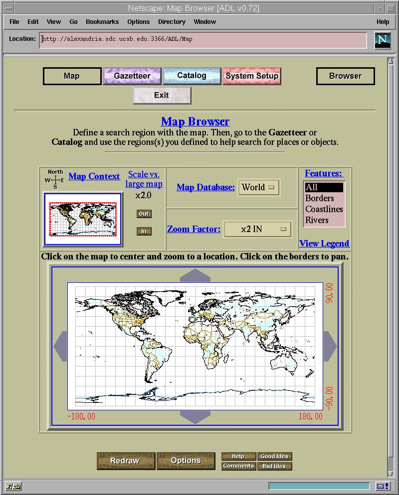
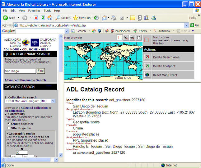
The HTML/CGI version of the Alexandria Digital Library Project.
The major contribution of the ADL project is to introduce digital library
services metaphor for distributed GIServices, and to extend the types of GIServices to cataloging, gazetteer searching, and metadata indexing. A third contribution of ADL is to explore Internet-based interface design processes. ADL utilized three different technologies for the actual implementation. The first version ran as a customized ArcView project. The second version was based on HTML and CGI programs. The final version ran as a Java applet and Java application. The ADL project explored different computer technologies and frameworks, identified major tasks of digital libraries, and become the first online service to provide comprehensive metadata browsing, display, and query functions for geospatial information. Recently, the Alexandria Digital Earth Prototype (ADEPT) is a follow-on to the Alexandria Digital Library Project (ADL). ADEPT aims to use the digital earth metaphor for organizing, using, and presenting information at all levels of spatial and temporal resolution with specific focus on geodata and images in California.
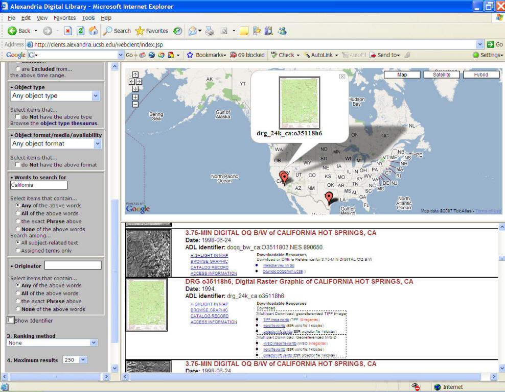
The ADL User Interface (2005).
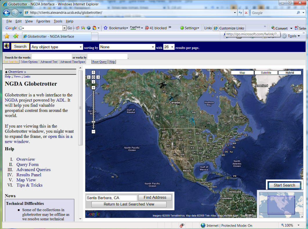
The NEW ADL User Interface (2007) with Google Map Mashup function.
![]()
The Standards
The three examples mentioned above illustrate the early development of distributed GIServices and their major contributions. However, these projects and prototypes utilize different types of Internet technologies and frameworks, and cannot share their data sets with each other. Therefore, the GIS community also aims to develop a standardized framework for the interoperability of GIServices. With the comprehensive architecture for bridging heterogeneous GIServices, researchers and scientists can easily share their geospatial data and GIS models.
Two major organizations that set standards for distributed GIServices are:
1. The Open Geospatial Consortium, Inc. (old name: Open GIS Consortium, Inc.) (OGC) ( http://www.opengis.org ) or (http://www.opengeospatial.org/)
2. The Technical Committee tasked by the International Standards Organization (ISO/TC211). ( http://www.isotc211.org )
Both organizations are founded in 1994. The main task of OGC is the full integration of geospatial data and geoprocessing resources into mainstream computing and the widespread use of interoperable geoprocessing software and geodata products throughout the information infrastructure. ISO/TC211 emphasizes a service-oriented view of geoprocessing technology and a balanced concern for information, application, and systems (Kuhn, 1997).
ISO is an international organization and its members are mainly from the public sector, including national standards bodies and organizations. For example, the US national standard body is American National Standards Institute (ANSI). On the other hand, OGC’s members come mainly from the private sector, including software vendors and GIS companies, such as ESRI Inc., ERDAS Inc., INTERGRAPH Corp., AutoDesk Inc., etc. Since the backgrounds and resources of OGC and ISO/TC 211 members are quite different, the strategy and emphasis of open and interoperable GIServices frameworks are not really compatible. Basically, OGC focuses on both abstract definitions of OpenGIS frameworks and the technical-oriented implementations of data models and (to a lesser extent) on services. ISO/TC 211 mainly focuses on the high-level definitions of the GIS standards from an institutional perspective.
![]()
UNIT TWO (Session Two):
![]()
User accounts and passwords
![]()
Access the On-line Forum for GEOG583
in Blackboard:
Blackboard URL:
https://blackboard.sdsu.edu/
![]()
INTERNET PROTOCOLS AND LANGUAGES
![]()
The Internet and its applications are built upon several protocols and languages. The following examples are the three most important protocols and language in the early development of the Internet.
TCP/IP (Transmission Control Protocol / Internet Protocol) is the combination of two protocols (TCP and IP). TCP is used for packaging information for transmission and IP is used for assigning a unique address for computers.
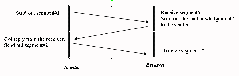
TCP mechanism
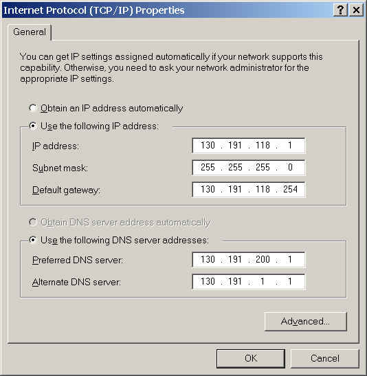
An IP address is a 32- bit integer and has four levels to consist a complete address name such as 128.130.170.14. Each level can use 0 to 255 value. So, the total maximum machines used in Internet can be 4,294,967,296 units, which at present time is still adequate to accommodate a great number of sites. The IP address implies the topology for the network connection and a local area network (LAN) may define a "mask" to filter some unnecessary signals from outside networks by using "bridge" or "router"( some devices used in networks) as a gateway for LANs.
IP Address Examples:
130.191.3.100 (rohan.sdsu.edu) SDSU Rohan Server
130.191.13.5 (www.sdsu.edu) SDSU Web Server
140.112.8.130 (www.ntu.edu.tw) National Taiwan University Web Server.
The TCP/IP reference model defines a four-layered network structure.
(User Applications)
Application layer
Transport layer
Internetwork layer
Network Access layer (MAC)

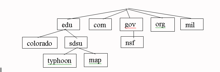
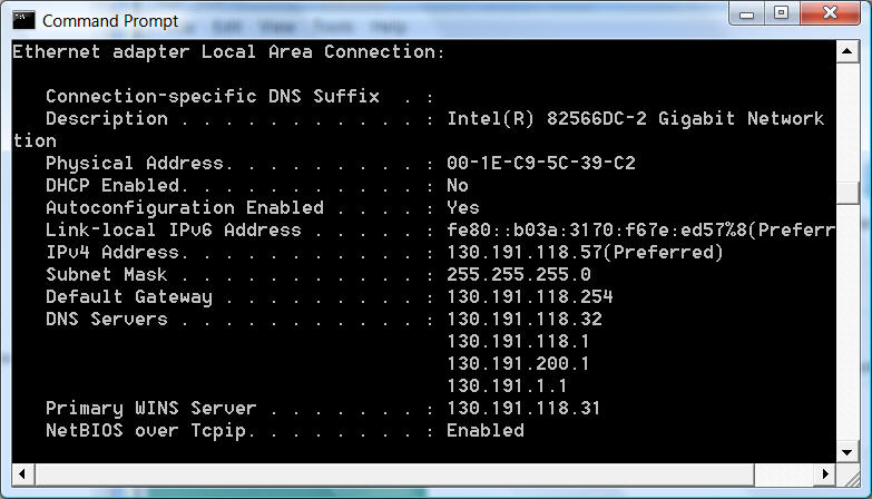
IP addresses are difficult to remember and pronounce. People who use the Internet would like to have a easier way to assign their servers and workstation, which is similar to the "mailing address" in our real world. Therefore, Paul Mockapetris designed the DNS in 1984 at the Stanford Research Institute's Network Information Center (SRI-NIC). The Domain Name System (DNS) is a distributed database used by TCP/IP applications to map between "hostnames" and "IP addresses", and to provide electronic mail routing information. The DNS has tree structure and is more flexible and memorable than the IP addresses. Each LAN (university department, campus or department within a company) maintains its own database of information and runs a server program that other systems across the Internet can query DNS can imply the hierarchy relationship in the local network. For example, San Diego State University has two DNS servers (130.191.1.1 and 130.191.200.1) The level of hierarchy is unlimited and the total number of a Domain Name Address could be 256 characters.
More information:
http://www.eli.sdsu.edu/courses/spring97/cs596/notes/networks/networks.html
DNS Architecture
NETWORK SETTING EXAMPLE:
Type "ipconfig" in your Commend Prompt Window.
HTTP (Hypertext Transfer Protocol)
"The Hypertext Transfer Protocol (HTTP) is an application-level protocol for distributed, collaborative, hypermedia information systems. It is a generic, stateless, object-oriented protocol which can be used for many tasks, such as name servers and distributed object management systems, through extension of its request methods. A feature of HTTP is the typing and negotiation of data representation, allowing systems to be built independently of the data being transferred." (Abstract from RFC 2616: Hypertext Transfer Protocol -- HTTP/1.1 , W3C http://www.w3c.org)
Additional Information: http://www.eli.sdsu.edu/courses/spring97/cs596/notes/http/http.html
Client/Server Relationships: Send messages --> Get messages --> Respond messages.
Similar to the use of "two-way radios" (walky-talky).
HTML (Hypertext Markup Language)
Wikipedia definition: http://en.wikipedia.org/wiki/HTML HyperText Markup Language (HTML) is the predominant markup language for the creation of web pages.
W3C definition: "HTML is the lingua franca for publishing hypertext on the World Wide Web. It is a non-proprietary format based upon SGML (Standard Generalized Markup Language), and can be created and processed by a wide range of tools, from simple plain text editors - you type it in from scratch- to sophisticated WYSIWYG authoring tools. HTML uses tags such as <h1> and </h1> to structure text into headings, paragraphs, lists, hypertext links etc. (Introduction from W3C's home page for HTML http://www.w3.org/MarkUp/)
Here is a 10-minute guide for newcomers to HTML. W3C's statement of direction for HTML is given on the HTML Activity Page."
Additional Information: http://www.eli.sdsu.edu/courses/spring97/cs596/notes/http/http.html
"Raggett on HTML 4" (1998), by Addison Wesley, ISBN 0-201-17805-2. The intelligent person's guide to HTML 4, as written by one of the chief architects of HTML, Here is the Chapter 1 from the book.
HTML 5: http://en.wikipedia.org/wiki/HTML5
![]() http://www.w3schools.com/html/html5_intro.asp
http://www.w3schools.com/html/html5_intro.asp
HTML5 will be the new standard for HTML.
The previous version of HTML, HTML 4.01, came in 1999. The web has changed a lot since then.
Some of the most interesting new features in HTML5:
| The <canvas> element for 2D drawing | |
| The <video> and <audio> elements for media playback | |
| Support for local storage | |
| New content-specific elements, like <article>, <footer>, <header>, <nav>, <section> | |
| New form controls, like calendar, date, time, email, url, search |
HTML 5 Geolocation: http://www.w3schools.com/html/html5_geolocation.asp
The getCurrentPosition() method returns an object if it is successful. The latitude, longitude and accuracy properties are always returned. The other properties below are returned if available.
| Property | Description |
|---|---|
| coords.latitude | The latitude as a decimal number |
| coords.longitude | The longitude as a decimal number |
| coords.accuracy | The accuracy of position |
| coords.altitude | The altitude in meters above the mean sea level |
| coords.altitudeAccuracy | The altitude accuracy of position |
| coords.heading | The heading as degrees clockwise from North |
| coords.speed | The speed in meters per second |
| timestamp | The date/time of the response |
![]()
![]()
References
Berners-Lee, T., Cailliau, R., Luotonen, A., Frystyk, N., & Secret, A. (1994). The World-Wide Web. Communications of the ACM, 37(8), pp. 76-82.
Buttenfield, B. P., & Goodchild, M. F. (1996). The Alexandria Digital Library Project: Distributed Library Services for Spatially Referenced Data. In Proceedings of GIS/LIS'96, Denver, Colorado, pp. 76-84.
Buttenfield, B. P., (1998). Looking Forward: Geographic Information Services and Libraries in the Future. Cartography & Geographic Information Systems, 25(3), pp. 161-171.
Huse, S. M. (1995). GRASSLinks: A New Model for Spatial Information Access in Environmental Planning. Unpublished doctoral dissertation. Berkeley, California: University of California at Berkeley, Department of Landscape Architecture.
Kuhn, W. (1997). Toward Implemented Geoprocessing Standards: Converging Standardization Tracks for ISO/TC 211 and OGC, White Paper. ISO/TC 211-N418.
Plewe, B. (1997). GIS Online: Information Retrieval, Mapping, and the Internet. Santa Fe, New Mexico: OnWord Press.
National Science Foundation (1994). NSF Announces Awards for Digital Libraries Research. NSF PR 94-52, Washington, D. C.: NSF.
Putz, S. (1994). Interactive Information Services Using World Wide Web Hypertext. In Proceedings of the First International Conference on the World-Wide Web, Geneva, Switzerland. URL:
http://www94.web.cern.ch/WWW94/PrelimProcs.html (date: 5-11-2000).Sloman, M., editor. (1994). Network and Distributed Systems Management. Wokingham, England: Addison-Wesley.
![]()
![]()
![]()
![]()
![]()