![]()
Geographic Information Science and Spatial Reasoning
(GEOG 104) (A General Education [GE] Course) Spring 2018
![]()
![]()
![]()
|
Geographic Information Science and Spatial Reasoning (GEOG 104) (A General Education [GE] Course) Spring 2018
|
|
| |
|
Geographic Information Science and Spatial Reasoning (GEOG 104) (A General Education [GE] Course) Fall 2015
|
Web-based Exercise #3:
Story Maps and Map Projection
![]()
Estimated time: 2.5 hour
Grading: 7 points total (ONE point for each question).
Due Day: October 13th at the beginning of lecture. You should upload your lab answers to the Blackboard ( http://blackboard.sdsu.edu ) before the lecture. We will use the Timestamp on your documents in the Blackboard to check if your assignment is late or not.
(Please always save a local backup copy of your own answers.)
If you don't have Internet access, you can use our SAL lab on every Friday morning from 11:00am to 1:00pm.
PART-1:
Building a Story Map (with ArcGIS Online).
What is a Story Map? Esri Story Maps
let you combine authoritative maps with narrative text, images, and multimedia
content. They make it easy to harness the power of maps and geography to tell
your story.
The Five Principles of Effective Storytelling (Please read
the following link first). –
(Content provided by Cynthia Paloma)
Task 1: Read the following items:
Who can make a Story Map?
•
Anyone with a web browser–
Stored in the cloud; no web server needed–
Simple web-based templates (Story Map templates) & tools–
Works on different devices•
Need ArcGIS Online account–
Public account: Free, but limited features–
Organization account: More available features, may collaborate
Story Map Templates
•
Currently 11 Story Map templates (web apps)–
http://storymaps.arcgis.com/en/app-list/•
General categories:–
Sequential, Place-based Narratives (2)–
A Curated List of Points of Interest (3)–
Presenting One Map (1)–
Presenting a Series of Maps (3)–
Comparing Two Maps (2)•
Can also build a custom template
Visit the Storymap examples in the California Geographic Alliance:
http://calgeography.sdsu.edu/geo-quest/
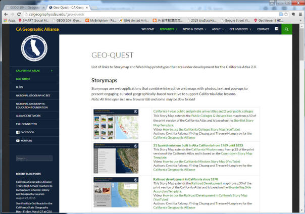
Q1) Select One Story Map Example from the GEO-QUEST (California Geographic Alliance) website. Briefly introduce your example. Who are the target audience? What is the URL of the storymap? Which "Template" does the example use? Why did the CGA choose this template for this Story Map example?
In [My Content:]
–
Web map listed as a Web Map–
Story map listed as a Web Mapping Application
Task 2: Read the following documents (in PDF format):
http://storymaps.esri.com/downloads/Building%20Story%20Maps.pdf
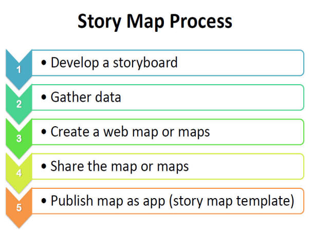
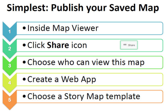
Task 3: Build your own StoryMap (using Lab-2 Web maps you created or you can create a new StoryMap).
Additional Help Documents:
The Five Principles of Effective Storytelling
–
http://storymaps.arcgis.com/en/five-principles/•
How to Make a Story Map–
http://storymaps.arcgis.com/en/how-to/•
Story Maps Web App List–
http://storymaps.arcgis.com/en/app-list/
Q2) How many different storymap templates provided by ESRI Web Apps? What is your Storymap? Please write a short description about your storymap and the URL for sharing. Which template do you use in your Storymap? Why choose this template?
PART-2: Map Projection and Coordinate Systems.
Please spend 5 minutes to read this class Lecture Note Unit-3 -- map projection part: (Click here)
Also, please spend another 5 minutes to read the following introduction about map projection:
http://en.wikipedia.org/wiki/Map_projection
After the readings, please answer the following question:
YouTube Video References:
https://www.youtube.com/watch?v=AI36MWAH54s
https://www.youtube.com/watch?v=2lR7s1Y6Zig
https://www.youtube.com/watch?v=bBMs_LpwYpU
Q3) What are the definitions of Map projection in Unit-3 and Wikipedia? What are the differences in their definition? Why do we need map projections ? __________________________________
2. On-line Map Projection Tool Exercise
• Click the link
http://kartograph.org/showcase/projections/#ortho . (Open a new Window for displaying the on-line Map Projection Demo tool.) This web application is developed by Gregor Aisch.
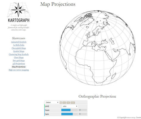
There are different demos for the map projections.
In the botton menu ("proj"), select “Mercator”, then the map will be re-projected as Mercator projection (Figure 2).
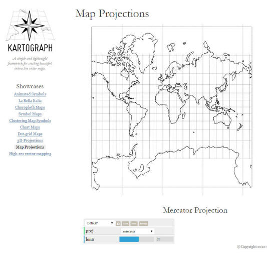
Figure 2: Mercator Projection
Read the brief introduction for the Mercator projection at http://en.wikipedia.org/wiki/Mercator_projection. ( 5 minutes)
Q4) Please answer these questions about the Mercator Projection: What type of projection is it ? (Cylindrical? Conic? or Plane?) What is a "conformal" projection? The Mercator projection is a conformal projection? What are the major strength and weakness of the Mercator Projection?
_______________________________________________
Now we need to visualize the map distortion for each different map project methods. . In cartography, we can use a special technique called, Tissot’s indicatrix. The Tissot’s indicatrix is using perfect circles patching on the Earth Globe surface, then with different map projections, the shape and size of the circles will be changed according to the different projection methods. These changes indicate the distortion of each map projection on the different locations of the Earth Surface.
• Read the brief introduction for the Tissot's indicatrix at http://en.wikipedia.org/wiki/Tissot%27s_Indicatrix.
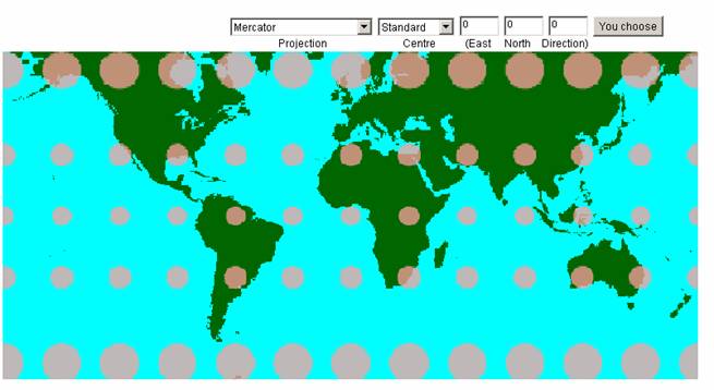
Figure 4: Tissot’s Indicatrix of Mercator Projection
Do the indicatrix indicate equal area or conformal projection?
The following map shows "Mollweide" projection
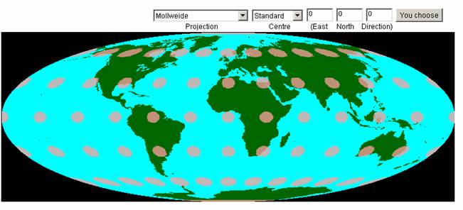
Figure 5: Mollweide Projection with Tissot’s Indicatrix
Q5) Please answer the questions about the Mollweide Projection. What are the differences of the circles (Tissot's Indicatrix) between the Mercator projection and the Mollweide projection? What type of projection is the "Mollweide" projection? (Cylindrical? Conic? or Plane? or Pseudo-cylindrical? ) What are the characteristics of the Mollweide projection (conformal, equal-area or equidistant)? (Hint: refer to http://en.wikipedia.org/wiki/Mollweide_projection)
Q6) Please use the tool http://kartograph.org/showcase/projections/ to compare the longitude and latitude lines (or called gratitude) for the three different projections: Mercator projection, Mollweide projection, and the Robinson projection. Which projection has straight lines? Which one has the most curved lines? Which one is better for displaying California? Why?
Q7) What is “Great Circle” and “Small Circle” in Cartography? (See the following web link: http://en.wikipedia.org/wiki/Great_circle , http://en.wikipedia.org/wiki/Small_circle, http://earthquake.usgs.gov/learn/animations/animation.php?flash_title=Great+Circles&flash_file=greatcircles&flash_width=450&flash_height=305 )
Please Answer Q1 - Q7 Questions
Due Day: October 13th at the beginning of lecture (12:30pm).
Note:
You should upload your lab answers to the Blackboard ( http://blackboard.sdsu.edu ) before the lecture. We will use the Timestamp on your documents in the Blackboard to check if your assignment is late or not.
This web site is hosted on MAP.SDSU.EDU
and Geography Department.
|
|