Web-based Exercise #3:
Location-based Services, User Intefaces, and Mobile GIS Apps.
Estimated time: 4 hours
Grading: 8 points total (ONE point for each question).
Due Day: Mar 22 at the beginning of lecture (2:00 pm). You should upload your lab answers to the Blackboard ( http://blackboard.sdsu.edu ) before the lecture. We will use the Timestamp on your documents in the Blackboard to check if your assignment is late or not.
(In your upload file, please use this title: [GEOG104-LAB-#-[Your name].doc (or txt or pdf). Please write down your answers in MS Word or WordPAD or other word processing software. Please always save a local backup copy of your own answers.)
This exercise will require smart phones to
install a few example apps. If you don’t have smart phone exercises,
please email your name to the TA (Melanie). Your TA will
arrange a check-out of iPod Touch or iPad from the Geography
Department for your exercise.
Please read the following articles (20
mins):
http://geoawesomeness.com/expected-trends-technological-advancements-location-based-services/
https://www.businessnewsdaily.com/5386-location-based-services.html
Q1 (one point): Please use your own words to define
"Locationb-based Services" and introduce one LBS application with the
related website link (with URL included in this report) (Do not use
the examples provided in this exercise).
Mobile App Example #1: Waze
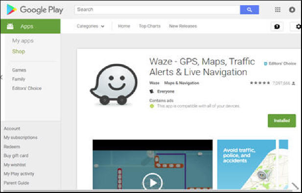
Waze is a traffic monitoring and
navigation app using crowd-sourced information (data provided by the
“crowd” – users). Take a look at the Waze info:
https://en.wikipedia.org/wiki/Waze
Install the “Waze” on your Smart phone
(using Google Play or iTune Store) or iPad or iPod touch.
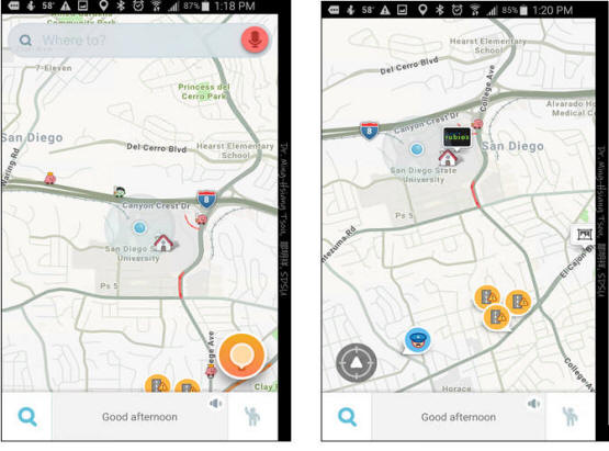
Test this “Waze” App for 15 mins.
Try the “search function” (top), or zoom
in to download San Diego to see the recent traffic updates or
incident reports.
Q2: Which Company acquired “Waze”
in 2013? How much money did the company pay for this
acquisition? (see
https://en.wikipedia.org/wiki/Waze).
Write down the major functions provided in the Waze App. Do you
like the user interface design of Waze? Why and Why not?
Provide one of your favorite function in Waze and one function you
don’t like. Make one screen shot of your favorite function in Waze
(attached in your report).
Note: To create a screenshot on
your smart phone, here are some tips:
Android Phones:
https://www.greenbot.com/article/2825064/android/how-to-take-a-screenshot-on-your-android-phone.html
iPhones:
https://support.apple.com/en-us/HT200289
Mobile App Example #2: iNaturalist

iNaturalist is a citizen science project
and online social network of naturalists, citizen scientists, and
biologists built on the concept of mapping and sharing observations
of biodiversity across the globe. (cited from
https://en.wikipedia.org/wiki/INaturalist).
Install the “iNaturalist” on your Smart
phone (using Google Play or iTune Store) or iPad or iPod touch.
Create your own iNaturalist account on the
app. Explore the observations around the SDSU campus. Try to
create your own observation into the iNaturalist.
Search for the project “SDSU Campus
bioBlitz” at the top of the page and click to JOIN THIS PROJECT
at the top right, once you are on the project page. Now, any
observation you make within the project area boundary (SDSU campus)
should be automatically added to the project.
Spend 20 mins to play this iNaturalist app
and create one new observation at SDSU campus. When you
make a new observation, take a screen shot and save it for the next
question.
Q3: Which company or organization
develop “iNaturalist”? Write down the major functions provided in
the iNaturalist App. Do you like the user interface design? Why
and Why not? Provide one of your favorite function in
iNaturalist and one function you don’t like. Make one screen
shot of your own observation at SDSU campus (attached the screen shot
in your report).
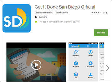
Mobile App Example #3: Get it Done San Diego
Official
Get It Done San Diego is the official app
for reporting non-emergency problems to the City of San Diego. App
users can report problems like potholes or graffiti and connect
directly to the City’s work tracking system.
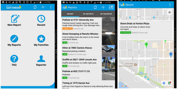
Spend 15 mins to play this app. Try the
different functions provided in the App. Take a look at the Recent
Report and click on the “Map view” (upper right corner in the Recent
Report Page). Can you see any recent report nearby your home?
Q4: Which company or organization
develop this app, “Get it Done San Diego”? Write down the major
functions provided in the App. Do you like the user interface
design? Why and Why not? Provide one of your favorite
function in “Get it Done” and one function you don’t like. Make
one screen shot of one recent Report in San Diego (attached the
screen shot in your report).
Mobile App Example #4: SD Emergency
The SD Emergency App contains disaster
preparedness information, interactive checklists to help you to
create your emergency plan, build an emergency supplies kit, and when
disaster strikes; the SD Emergency App will keep you and your family
informed with emergency updates, interactive emergency maps, and
shelter locations.
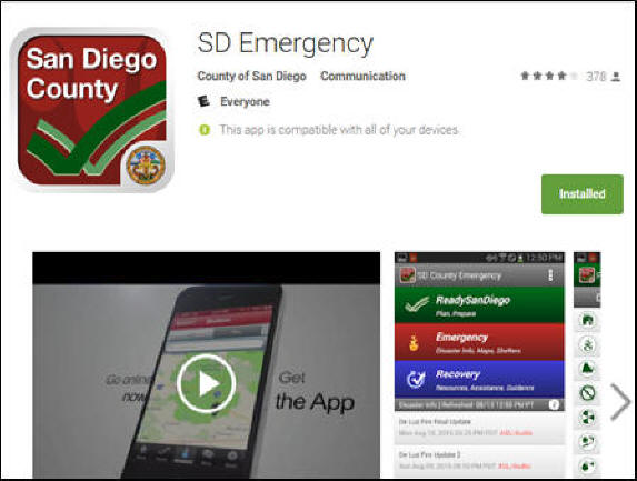
Install the “SD Emergency” on your Smart
phone (using Google Play or iTune Store) or iPad or iPod touch.
Explore the information in ReadySanDiego, Emergency, and Recovery
Sections.
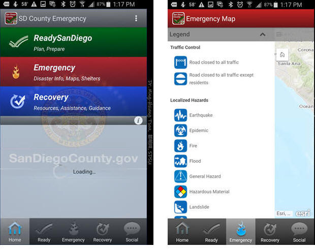
Try different functions and tasks in this
app. Go to the Emergency Tab, and open the “Emergency Map”.
This map may look empty now since there is no disasters in San Diego
now. But take a look at the legend in the map and see how many
different types of information can be integrated into this app.
Write down the list of the layers.
Q5: Which organization develop
this app, “SD Emergency”? Write down the major functions provided
in this App. Do you like the user interface design? Why and Why
not? Provide one of your favorite function in this app
and one function you don’t like. Write down the list of map
layers provided in the Emergency Map. Attached a screen shot of your
favorite function in the App.
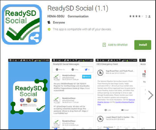
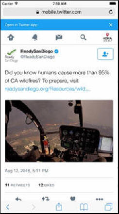
Mobile App Example #5: ReadySD Social
This mobile app allows you to re-send
up-to-date emergency public information to your friends and contacts
during crisis or disaster situations. Your participation ensures that
each OES message will be delivered to our San Diego community members
in a timely and efficient manner. This app is developed by the
Center for Human Dynamics in the Mobile Age at San Diego State
University. https://play.google.com/store/apps/details?id=com.ionicframework.volunteer789118
Getting Started
1. The ReadySD
Social App is available in both iOS and Android platforms.
a.
For Android users, go to Google Play and search
for “ReadySD Social” to install.
b.
For iPhone or iPad users (iOS), go to the App Store
and search for “ReadySD Social” to install.
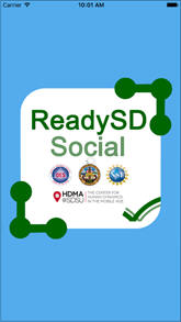
2. Once the app
is installed, you are ready to launch the ReadySD Social App! You
will be welcomed by the following splash screen:
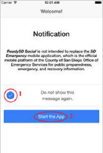
3. A welcome page,
which contains a Notification message, will appear and you
will be given the option to opt from showing the message again (1).
Click on “Start the App” (2) to begin.
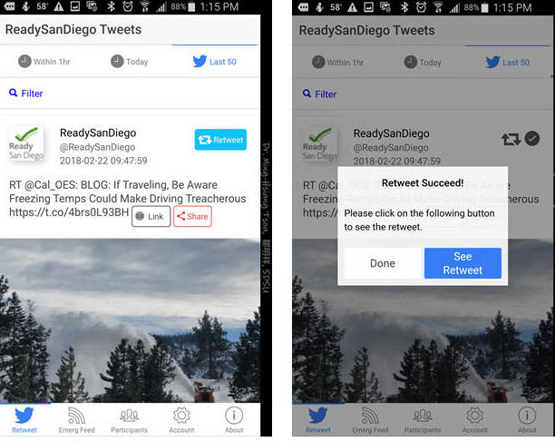
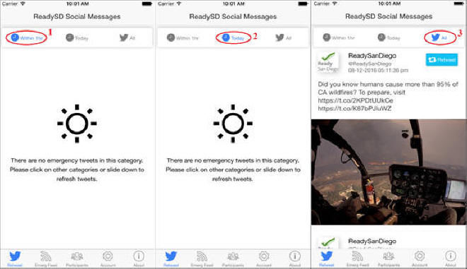
4. The
ReadySD Social Messages screen is now visible. You can navigate
through different tabs. The first tab in the bottom menu is the
Retweet tab in which the twitter messages are displayed.
You have three options for display: (1) within 1 hour, (2) today, or
(3) all of the twitter messages.
5. The rest of the
tabs in the bottom menu are as follows: Emergency Feed
(1), Participants (2), Account (3),
and About (4). The Emergency Feed
(1) allows you to open the link and email the link to your
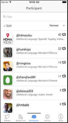
friends. The Participants tab (2) will list all
the participants in San Diego involved in the project once you
receive a confirmation email approving your registration. Please feel
free to navigate through the tabs (1 – 4).
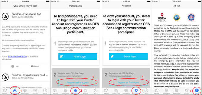
The Participants List
(2) will appear after registration approval
6.
The next step is to “Register as Participant” (Note this
step is optional. Since you will need to create a Twitter
account in order to register. You can choose to register as
Participant or just use this app’s limited functions without
registration). This will not have impact to your grade of this
exercise. If you register as participant, you can help the San
Diego community to re-send emergency news to more people.
7.
After clicking on the “Register as Participant” link, you will
be asked to provide your information through the “San Diego OES
Communication Participant Signup Form”. Follow the procedures and
provide your information.
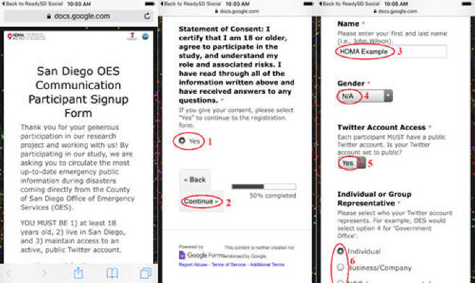
8.
After submitting the participant signup form, the HDMA Center
will review your registration within one or two days and will send
you a confirmation email approving your registration. Once your
application is reviewed you are ready to login to your account.
9.
Go to the Participant or Account
tab in the bottom menu and login to your Twitter account by clicking
the “Twitter Login” link (1). Provide your email address and password
used to login to Twitter (2-4). You will be logged in automatically
next time!
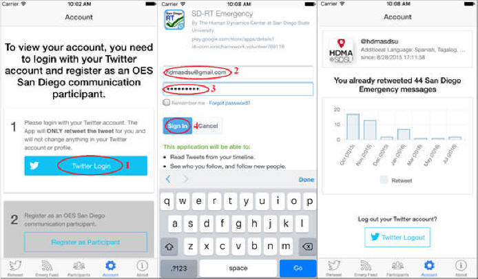
10. After logging in, you can go back to
the Retweet tab and start retweeting the ReadySanDiego twitter posts!
You can retweet your OES messages (1), or add your personal message
(2) or see your retweet! (4)
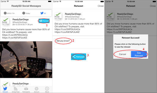
The ReadySD Social Messages you retweet
will show up as in a new window once you click “See Retweet.”
Spend 20 mins to explore different
functions in this App.
Q6: Which organization develop
the app, “ReadySD Social”? Write down the major functions
provided in this App. Do you like the user interface design?
Why and Why not? Provide one of your favorite function in
this app and one function you don’t like. Provide one screen shot of
the emergency message example provided in this App (from the Last 50
tweets in the RETWEET tab or from the Emregency Feed tab).
Q7: Compare the five previous
examples of mobile GIS apps. Which apps are examples of
“Location-based Services”? Which apps are using
“crowd-sourcing” framework? Which apps are creating “citizen
science”? Search for one new example of location-based
services and provide a brief introduction of the app and a
screenshot.
Q8: Read the following two articles
about the “locational privacy” issue:
·
http://www.nytimes.com/2009/09/01/opinion/01tue4.html
·
https://www.fastcompany.com/3068846/how-your-location-data-identifies-you-gilad-lotan-privacy
Do you agree or disagree with the
arguments in the two articles? What is your own opinion about
the locational privacy? Do you have major concerns of locational
privacy? Do you want to protect your own locational privacy? Or
you don’t think this is a major problem for LBS?
Due Day: March 22 (Thursday) at
the beginning of lecture (before 2pm).
You should upload your lab answers to the Blackboard (http://blackboard.sdsu.edu)
before the lecture. We will use the Timestamp on your documents
in the Blackboard to check if your assignment is late or not.
(In your upload file, please use this title: [GEOG104-LAB-2-[Your
name].doc (or pdf). Please
write down your answers in MS Word or other word processing software.
Please always save a local backup copy of your own answers.)
Web Exercise Questions:
Q1 (one point): Please use your own
words to define "Locationb-based Services" and introduce one LBS
application with the related website link (with URL included in this
report) (Do not use the examples provided in this exercise).
Q2: Which Company acquired “Waze” in
2013? How much money did the company pay for this acquisition?
(see
https://en.wikipedia.org/wiki/Waze). Write
down the major functions provided in the Waze App. Do you like
the user interface design of Waze? Why and Why not?
Provide one of your favorite function in Waze and one function you
don’t like. Make one screen shot of your favorite function in
Waze (attached in your report).
Q3: Which company or organization
develop “iNaturalist”? Write down the major functions
provided in the iNaturalist App. Do you like the user interface
design? Why and Why not? Provide one of your favorite
function in iNaturalist and one function you don’t like. Make
one screen shot of your own observation at SDSU campus (attached the
screen shot in your report).
Q4: Which company or organization
develop this app, “Get it Done San Diego”? Write down the
major functions provided in the App. Do you like the user
interface design? Why and Why not? Provide one of your
favorite function in “Get it Done” and one function you don’t like.
Make one screen shot of one recent Report in San Diego (attached the
screen shot in your report).
Q5: Which organization develop this
app, “SD Emergency”? Write down the major functions
provided in this App. Do you like the user interface design?
Why and Why not? Provide one of your favorite function in
this app and one function you don’t like. Write down the list
of map layers provided in the Emergency Map. Attached a screen shot
of your favorite function in the App.
Q6: Which organization develop the
app, “ReadySD Social”? Write down the major functions
provided in this App. Do you like the user interface design?
Why and Why not? Provide one of your favorite function in
this app and one function you don’t like. Provide one screen shot of
the emergency message example provided in this App (from the Last 50
tweets in the RETWEET tab or from the Emregency Feed tab).
Q7: Compare the five previous
examples of mobile GIS apps. Which apps are examples of
“Location-based Services”? Which apps are using
“crowd-sourcing” framework? Which apps are creating “citizen
science”? Search for one new example of location-based
services and provide a brief introduction of the app and a
screenshot.
Q8: Read the following two articles about
the “locational privacy” issue:
·
http://www.nytimes.com/2009/09/01/opinion/01tue4.html
·
https://www.fastcompany.com/3068846/how-your-location-data-identifies-you-gilad-lotan-privacy
Do you agree or disagree with the
arguments in the two articles? What is your own opinion about
the locational privacy? Do you have major concerns of locational
privacy? Do you want to protect your own locational privacy? Or
you don’t think this is a major problem for LBS?
