|
|
|
|
|
|
Study Area | ||||||||||||||||
|
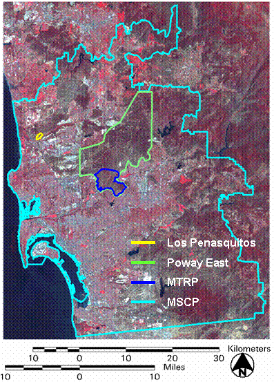
Assessment of image-based habitat quality and habitat change was carried out at three primary study sites: Mission Trails Regional Park, Poway East open space area, and Los Penasquitos Canyon Preserve. The climate of the study region is typical of Mediterranean ecosystems, with an average annual precipitation of 25 cm and an evaporation rate of 70 cm per year. Most precipitation occurs in winter. Mission Trails Regional Park (MTRP) in San Diego, California is one of the largest regional parks in the nation, incorporating approximately 2200 hectares of sage scrub, chaparral, and grassland habitat. The park is administrated by the City of San Diego and is roughly 7 km by 10 km. This park is surrounded by urban fringe and is heavily utilized for recreation. Terrain ranges from 24 - 485 m in elevation. Levels of recreation intensity vary throughout the park, and certain areas are designated specifically for recreation activities. Mechanical disturbances include vegetation removal and soil compaction from mountain biking, Biking Motocross (BMX), hiking, and horses . |
|||||||||||||||||
 |
Data | ||||||||||||||||
|
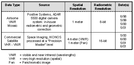
Operational monitoring of southern California habitat reserves requires moderate to high spatial resolution satellite imagery for large area coverage and supplementary, site specific very high spatial resolution airborne imagery for detailed characterization of land cover and change. Two primary types of imagery were evaluated for monitoring southern California shrubland habitat: IKONOS multispectral satellite imagery and ADAR 5500 multispectral airborne imagery. Data used is summarized in the table below: |
|||||||||||||||||