GEOG 581: Cartography Design
![]()
![]()
![]()
![]()
![]()
Session ONE
![]()
INTRODUCTION
Instructor: Dr. Ming-Hsiang Tsou
What will you be learning in this class:
| Advanced cartographic principles and Theories (Communication and GeoVisualization). |
| Establish hands-on experiences on cartographic techniques and software packages (ArcGIS, ArcIMS, Dreamwaver, Flash). | |
| Explore the future research topic in advanced cartography. (Visualization, Animation, Web-based mapping, etc.) |
Finish the survey page and return to the instructor at the end of class.
Introduce yourself.
Showing Movie (ESRI 2004 Internationa User Conference and Interactive mapping table).
Questions:
| What is "Cartographic Design"? | |
| What are the differences among "Thematic Mapping" and "General Reference Maps"? | |
| What are consequences of the technological change in Cartography? |
(Please read chapter one of Slocum's book. This course will focus on the seminar type discussion rather than lectures only).
NO CLASS (Lectures) on Tuesday
![]()
Session TWO
![]()
![]()
Definition of "Cartographic Design".
Visualization Aspect:
| The visual representation of geographic and spatial information. (Lauren Rizzo). | |
| The scientific, artistic, representation of spatial phenomena. (David Palomino). | |
| The design/construction of information in a visual manner. (Kimberly Brown). |
Communication:
| A map that conveys meaning, as well as the elements of the layout and methods for dissemination. (Merrilee Willoughby). |
| Creating maps which clearly convey information and are nice to look at. (Karen Pankey). |
| Designing a map that conveys information to the user in a clear, usable, understandable fashion. (Erica Bishop). |
Map Making:
| Nature, physical process in which maps are conceived and created -- making of maps. (Matt Shibel). | |
| The theoretical and practical foundations to create maps. (Rosanna Petralia) |
| The layout of the physical landscape on a form of media. (Tod Chee). | |
| The process of selecting and arranging map features (symbology, color, etc...) in order to allow a greater understanding on the part of the map reader. (Andy Gordon). |
User-oriented:
| It is a skill to be trained and a foundation of spatial analysis and for decision makers. (Jing-Yi Chen). | |
| Cartographic design is more than just making maps, it is how to present maps so they interest its viewers and users. (Philip Gibbons). | |
| Cartographic design is an interpretation of an area or space visually represented to another person. (Ken Smith) | |
| The ability to create a map that will appropriately display/represent an area, and be understandable to others. (Asia Addlesberger). |
Geographic Information:
| Methods and principles used to display information in hard or soft copy format with a focus on geographic information. (Jennifer Larson). | |
| A stylized interpretation of the earth surface. (Federick Dequina). |
Computer-oriented
| Designing maps using different tools ranging from drawing a map or using a computer to create a map. (Alvaro Estrado). | |
| Production of maps through computers and GIS (Joseph Morin). | |
| The creation and design of interactive maps using computer software. (Addie Olazabal). |
![]()
Four Key Questions: (from Phillip C. Muehrcke, 1996, Chapter 19: The Logic of Map Design, Cartographic Design: Theoretical and Practical Perspectives, edited by C. H. Wood and C. P. Keller, Wiley.
| What do we mean by cartographic design? | |
| What are the most basic principles of map design? | |
| How do we distinguish well-designed maps from poorly designed ones? | |
| Is it possible to teach a map design sense, or is it a talent some innately have and others don't? |
![]()
Different Types of Maps
| General Purpose (Reference Maps) | |
| Thematic Maps | |
| Pragmatic Maps | |
| (Charts). (Maps especially designed to serve the needs of navigators, nautical and aeronautical, are called charts. (Robinson, et al. 1978). | |
| Mental Maps. | |
| ? anything else? |
Please give an example of each map type

(This picture is modified from Dr. Barbara Buttenfield's lecture notes.)
Questions: What are the differences among "Thematic Mapping" and "General Reference Maps"?
From Slocum's book (2004):
| Thematic maps (or statistical maps) are used to emphasize the spatial pattern of one or more geographic attributes (or variables), such as population density, etc. | |
| General-reference maps are used to emphasize the location of spatial phenomena.... |
Is pragmatic maps belong to thematic maps? (according to this definition?)
From Robinson's book (1978):
| Thematic Maps concentrate on the spatial variations of the form of a single attribute or the relationship among several. ... Thematic maps are commonly small-scale maps largely because many geographical distributions occur over considerable areas. | |
| General, or reference, maps are those in which the objective is to portray the spatial association of a selection of diverse geographical phenomena. |
Can you think of any map example for thematic maps with large scale?
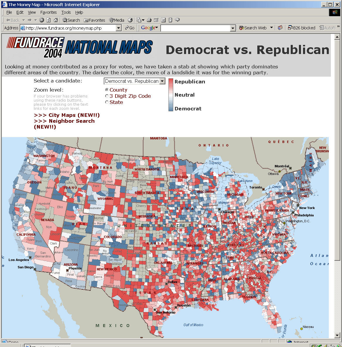
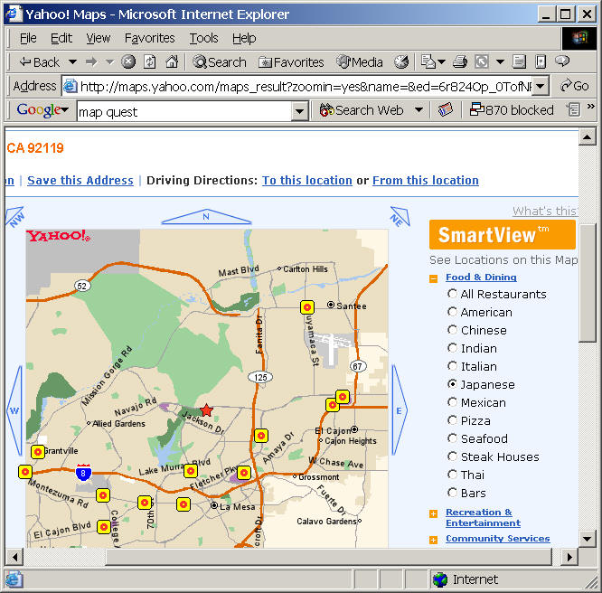
Thematic Maps or Reference Map?
http://maps.yahoo.com/ --> SmartView (switch between reference maps and thematic maps?
![]()
Question:
| What are consequences of the technological change in Cartography? |
Computers become a new technology to Cartography after World War II.
Automated Cartographic Systems"? (D. R. F. Taylor, chapter 1): Despite the wide use of the term there is really no such thing as "automated cartography". It is true that many mapping agencies are automating processes previously carried out mannually, some of these using computer technology; but the computer will never totally replace the cartographer.
Computer-assisted cartography (C.A.C): (cited from David Rhind, 1980, chapter 3, The nature of computer-assisted cartography): The first successful attempts to produce graphics from computers were reported in the early 1950s. By the middle of that decades, maps were being produced on the now-standard computer output device, the line printer, on the earliest cathode ray tubes, or on tabulating equipment. ... The vast bulk of the research and development work in C.A.C. to date has been of a technical kind.
Examples: The SYMAP program, created by Howard T. Fisher and developed at the Laboratory for Computer Graphics and Spatial Analysis in Harvard University.
http://www.gisdevelopment.net/history/1960-1970.htm
| New book: Charting the Unknown: How computer mapping at Harvard become GIS by Nick Chrisman. 2005. | |
| http://gis.esri.com/esripress/display/index.cfm?fuseaction=display&websiteID=82&moduleID=0 |
From Slocum's book: (page 1).
Today nearly all maps are produced using computer technology... The consequence including:
Discussion:
| Anyone can create maps. | |
| Map makers without map trainings? |
| Animation Maps: | |
| San Diego Wildfire 2003, SDSU Geography. http://map.sdsu.edu/ |
| Data Exploration (Exploratory spatial data analysis (ESDA): | |
| Space Time Analysis of Regional Systems (Dr. Serge Rey, SDSU) http://stars-py.sourceforge.net/ | |
| http://irsr.sdsu.edu/~serge/stars/linking.mov (demo movie) |
| Multimedia Maps: | |
| National Atlas of the United States http://www.nationalatlas.gov/atlasvue.html#multimedia |
| Virtual reality and augmented reality: | |
| http://www.cs.unc.edu/~azuma/azuma_AR.html (cited from this web page: In Augmented Reality, the user can see the real world around him, with computer graphics superimposed or composited with the real world. Instead of replacing the real world, we supplement it. Ideally, it would seem to the user that the real and virtual objects coexisted.) | |
|
Immersive Visualization Immersive AHAA (Advanced Horizon Attribute Analysis) is an integrated immersive visualization tool for creation, visualization and interpretation of horizon and volume attributes of 3-D seismic data. It enables teams to use 3-D visualization technology for interpretation, field exploration, reservoir characterization and development planning. | |

(Movie) Virtual Bus Stop. http://www.bpvizcenter.com/media.php
| Web-based Mapping (Internet Mapping & GIS). | |
| (GEOG 583 Internet Mapping http://map.sdsu.edu/geo596 ) | |
| Article in the GIS@development magazine: http://www.gisdevelopment.net/magazine/years/2004/july/29.shtml |
![]()
Cost of new technology?
Discussion:
More poor designed maps?
More expensive equipments?
Fewer Cartographers? (Questions?)
Abandon of cartography tradition? What is the cartography tradition?
![]()
Meeting at the Richard Wright SAL lab (SH338).
(NO LAB exercises at the first week)
Getting Started at the LAB.
User accounts
Password.
Please post your answers (using online forum) to the following questions:
|
What are the differences between C. A. C. and Geographic Information Systems? |
![]()
Web-powered by: MAP.SDSU.EDU