GEOG 581: Cartography Design
![]()
![]()
![]()
![]()
![]()
Getting Started with ArcMap
![]()
10 points, designed by Dr. Ming-Hsiang Tsou, 9-8-2004
First of all, spend 10 minutes to Read the web-based document about ArcGIS Desktop and briefly browse the contents of ESRI's websites:
http://www.esri.com/software/arcgis/about/desktop.html
![]()
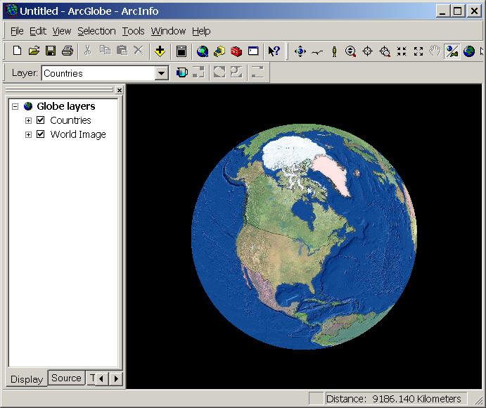
Task One: ArcGlobe
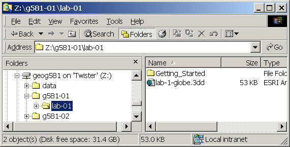
Use the File Explore (right click on the START menu, then select Explore) to create a "lab-01" folder in your own directory.
Launch the ArcGlobe from the Start menu --> Program --> ESRI --> ArcGIS 9.0 --> ArcGlobe
Use the navigation tool
![]() (with left mouse button) to rotate the Earth. The
Zoom-In/Zoom/out tool
(with left mouse button) to rotate the Earth. The
Zoom-In/Zoom/out tool ![]() (with right
mouse button).
(with right
mouse button).
Double click on the Legend (Table of Content) for "Counties" to open Layer Properties. (Or select
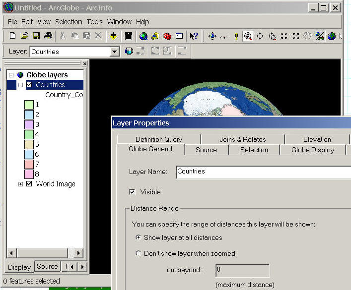
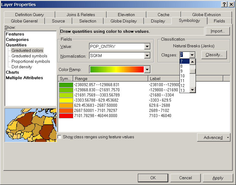
In the Layer Properties, click on Symbology Tab, then change the "Show:" information to "Quantities-- Graduated Colors"
(Questions: How many different types of data disply (show) specified in the Symbology window? What are the differences between
| Features | |
| Categories | |
| Quantities | |
| Charts | |
| Multiple Attributes | |
| (What kinds of measurement levels for each type? ) |
The next step is to change to Field Value to [POP_CNTRY] (population) and normalization by "SQKM") (areas), then select class as "7". and Choose the [Green-to-Red (Slope)] color Ramp.
Click on [OK] to apply it.
The next step is to use the Transparency icon to change the transparency of Countries layer to 5%.
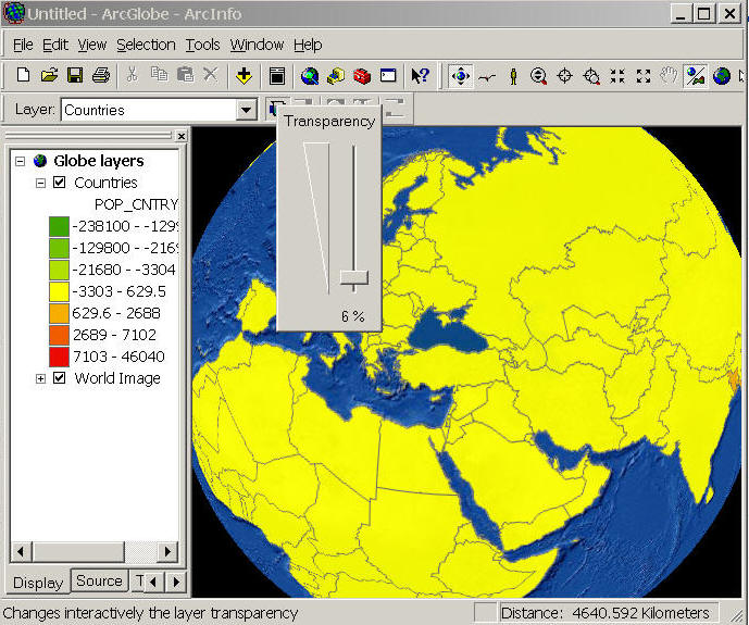
What happen? Does this map shows the population density of the different countries? WHY?
To correct the problem, double click on the Countries layer again to open the layer property. Something must be wrong in our classification. Click on the "Classify" icon to open Classification box.
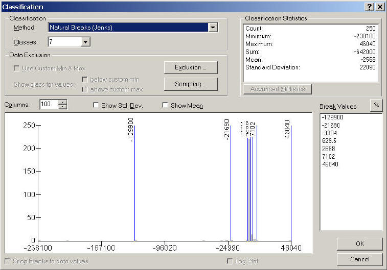
The gray areas show the data distributions and the blue lines show how the ArcGIS partition the data. In this graph, we can see most of the counties are in a single class and only very few counties are in other classes. To change that, let's select "Quantile" methods. Click on "OK" to apply this change. Then Click on [OK] again in the Layer property window.
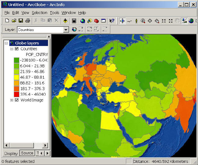
See the change in ArcGlobe now.
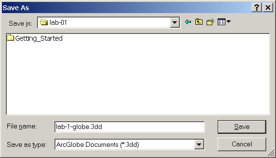
Click on File --> Save as --> Save your map into Z:\g581-##\lab-01\lab-1-globe.3dd
Spend 5 minutes to learn different ArcGlobe functions. Then close the window.
Questions: What kinds of map in ArcGloble? (Thematic / Reference / Pragmatic?) (1D, 2D, 3D or 2.5D?) (What level of measurement?)
![]()
Task Two: ArcMap Exercise
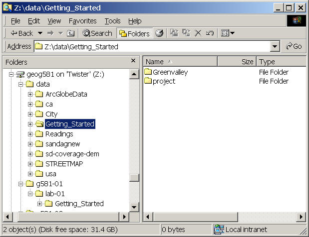
Copy the folder Z:\data\Getting_Started into your lab-01 folder.
Use the File Explore ( to navigate to Z: drive /data/Reading
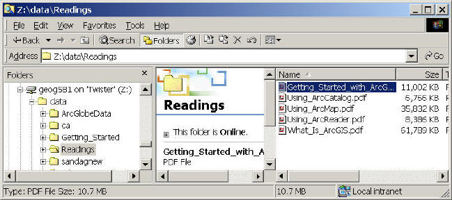
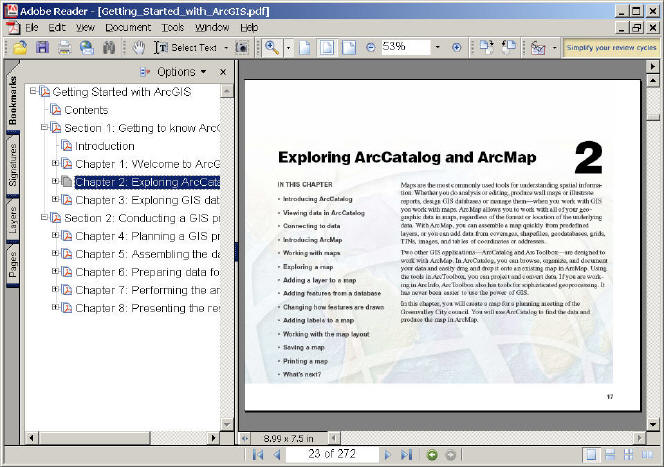
Double click on the PDF file (Getting_Started_with ArcGIS).
Go to Chapter 2 (page 23) and start to follow the instructions. (Replace E: drive to Z: drive \data folder in your exercises)
On Page 25, we don't have the "CL" coverage, try other data objects, such as sd_roads.shp for your ArcCatalog exercises.
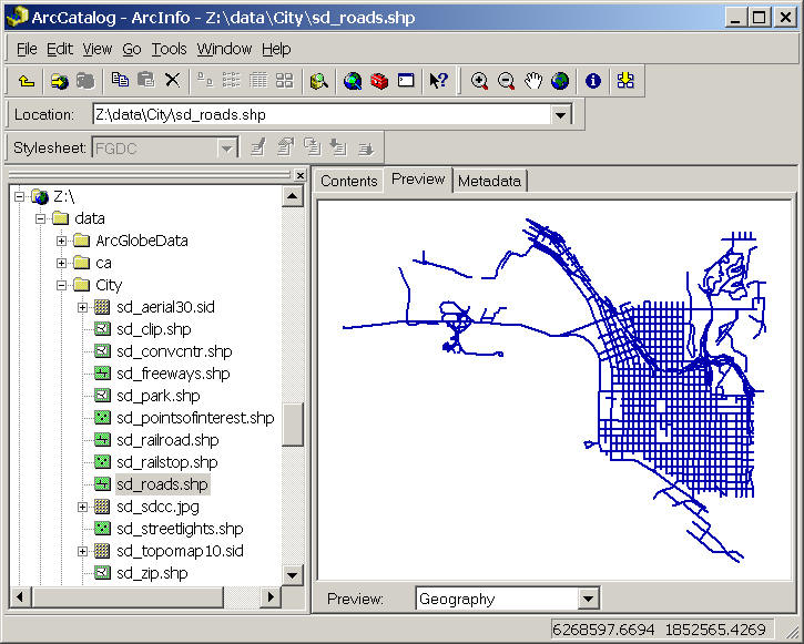
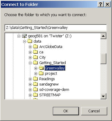
On Page 26, make connection to Z:\g581-(your-folder)\lab-01\Getting_Started\Greenvalley
Finish the exercise of Chapter 2 (page 23-50).
| Page 47 (add your name into the title) | |
| Save your map into Z:\g581-##\lab-01\ folder. | |
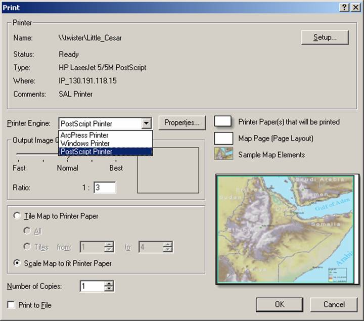
| Use [little Caesar] printer to print out the final map (put your name on the map). |
To print out your map, click on the Printing... to open the print window. Then select "PostScript Printer" as the Printer Engine. Output Image Quality as Normal or Fast. Then [OK] button to print out the map.
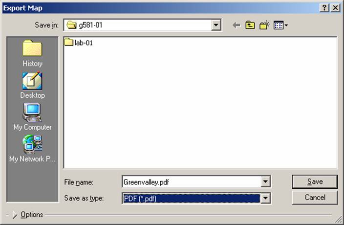
Some machines may has another error message like "cannot create metafile". To solve this printing problem, you can "Export" your map to PDF or image format, then print it out.
To export Map, Select "File" menu --> Export Map... --> then select PDF format, --> Save the PDF map into your own lab-01 folder.
![]()
![]()
Additional trainings and exercises for ArcGIS destop:
Book: Getting to Know ArcGIS
http://gis.esri.com/esripress/display/index.cfm?fuseaction=display&websiteID=49
ESRI Virtual Campus: http://campus.esri.com/
![]()
LAB Assignment (by next Thursday)
![]()
1. Print out the Greenvally Map. (5 points)
2. Please Use the On-line Forum to Answer the following questions: (5 points)
|
What kind of maps is your first printout map? (Greenvalley) Thematic map or Reference map or Pragmatic map? (Explain WHY). | |
|
What's the major differences between ArcGlobe and ArcMap (compare their functions, usability, and map display methods). Which one did you prefer? WHY? | |
|
How many different classification methods provided by the ArcGlobe or ArcMap? Please list all of them with a brief explanation of each methods. (Suggestion: you can use ArcGIS Desktop Help (from the program menu) to find out the answers) |
![]()
Web-powered by: MAP.SDSU.EDU