Wildfires are fires caused by nature or man and regularly occur in the forests and rangelands of the western United States, especially during the summer. These fires can be both beneficial and detrimental. Many plant species require an open area of ground in order to regenerate. Fires can clear the ground of vegetation, creating an open area for new plants to grow. However, fires can also burn very intensely in some areas, destroying property and claiming lives.
Predicting where a wildfire is going to start is very difficult as this is often a random event. Yet with good planning and fire prevention practices many potentially devastating wildfires can be avoided. Effective planning and prevention of wildfires depends on timely access to and analysis of geographic data describing fire-contributing conditions. Where a fire burns and how quickly it spreads is thought to be a function of topography, vegetation with its fuel and moisture content, and weather conditions, among other things. For example the steeper the slope, the easier it is for fire to spread up the hill. Southern aspects tend to burn more readily than northern aspects. Higher elevations tend to have smaller, less frequent but more severe fires than low elevations. Land use and topography also have a relationship with fire, especially with regard to vegetation. Many vegetative communities are influenced by topographic factors such as elevation, aspect, and landform. Fires will burn differently depending on the type of vegetation an area supports. Flammability levels will change as vegetation composition, structure, and productivity changes occur. Vegetation, its moisture and fuel content may also be influenced by anthropogenic factors such as cultivation, settlement, and management practices.
Data about topographic characteristics of fire prone areas, moisture and fuel status of the vegetation cover, and weather conditions can be captured, stored, managed, and analyzed using geospatial information technologies. These technologies include geographic information systems (GIS), remote sensing (RS), global position systems (GPS), and spatial decision support systems (SDSS). Fundamental to these technologies is collecting data about specific locations that can be depicted on maps and referenced to a corresponding location on earth. Geospatial information technologies are part of a larger information infrastructure that includes remote sensing platforms and data networks. Together they afford powerful data collection and processing capabilities for wildfire planning and prevention.
GIS is one of the geospatial information technologies that can be used to store, manage, and analyze geographical data about natural and human factors contributing to wildfires.
The analysis can be static based on the statistical analysis of association pattern between fire-contributing factors and past fire occurrences. A result of such an analysis may be a map representing the likelihood (probability) of wildfire occurring in a given area (see the map below). Probabilistic and deterministic maps of fire-prone conditions derived from the analyses of physical and human factors can provide effective decision support for fire prevention planning.
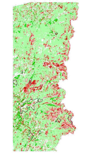
Figure 1 - Probability of fire based on vegetation moisture and fuel content. Low probabilities are shown in green, and high probabilities are shown in red. The black line outlines are the perimeters of past fire events.
Wildfires can also be analyzed as dynamic phenomena that change in time and space. A simple yet effective approach to tracking a wildfire behavior over time may be an animated map (see the map below).
Visualizing the progression of a wildfire correlated with landscape features may be an effective exploratory tool in aiding our understanding of wildfire phenomenon.
Often, predicating wildfire behavior can support wildfire prevention and planning. The prediction of wildfire behavior requires a modeling approach, in which changes in fire direction, intensity, temperature, and geographical extent of burned areas are simulated over time. Many simulation models of wildfire behavior have been developed either as stand-alone tools or as add-ons to GIS software. A collection of wildfire behavior modeling tools can be found on the web site http://www.fire.org. Combined with GIS, wildfire behavior simulation models can be used as spatial decision support systems to aid fire managers in generating and evaluating the consequences of various wildfire scenarios. One example of a wildfire behavior simulation model is FARSITE (see the screen capture below). FARSITE is used by the USDI National Park Service, USDA Forest Service, and other federal and state land management agencies to simulate the spread of wildfires for resource benefit across the landscape.
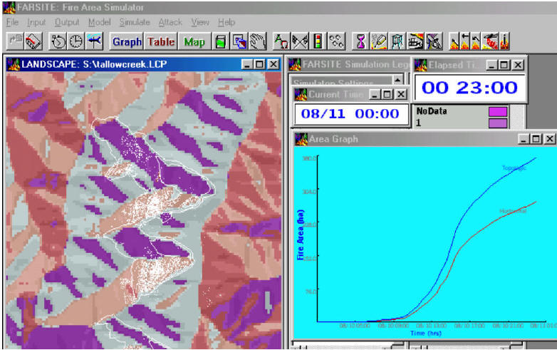
Figure 2 - Simulation of wildfire behavior in FARSITE; map (on the left) depicting the burned out areas (white dots) and graph (on the right) depicting the temporal progress of fire.
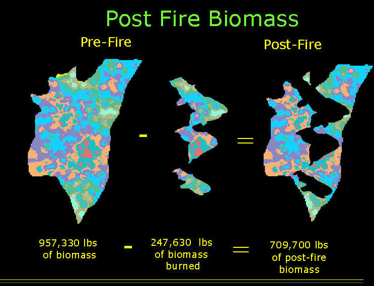
The results of simulations can help land managers learn about the impacts of likely wildfires on natural systems characteristics, such as for example change in the biomass of an ecosystem (see the slide below).
The challenge for GIS and other geospatial technologies used for wildfire mitigation is to develop a real-time wildfire management system that would be highly effective in predicating changes of wildfire behavior as the fire burns. The difficulties in accomplishing such a system are numerous and result from the volatile nature of wildfire dynamics.