Multiple Species Conservation Program (MSCP) Habitat Monitoring: Remote Sensing Research at San Diego State University
|
Multiple Species Conservation Program (MSCP) Habitat Monitoring: Remote Sensing Research at San Diego State University |
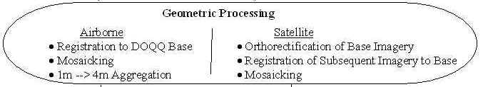
Geometric Processing
Different geometric processing methods were utilized on both airborne and satellite imagery. For the purpose of this overview the description of geometric processing will be limited to ADAR image data. The ADAR imagery is registered to a Digital Ortho Quarter Quad (DOQQ) Color Infrared (CIR) air photo base image. This is accomplished by an image analyst who visually identifies common Ground Control Points (GCPs) in both the ADAR scene and the DOQQ. The analyst then plots a network of these GCPs which are then used in an algorithm which creates a mathematical model of the GCP network which is then used to transform the image into real world coordinates. This process can be very time consuming and tedious for the analyst as it requires several GCPs to produce images which are accurately registered to the base image. In a change detection context, date to date imagery must also have highly accurate registration between date, or changes may be identified that are simply artifacts of the mis-registration between dates. 1 meter resolution ADAR data proved to be difficult to accurately register to within 1 pixel (1 meter), especially in areas of high relief. The limitations of this 1 meter data are summarized below.
Accuracy of spatial registration for multi-temporal ADAR imagery (1m resolution) varies between 1 to 5 meters and is dependent on topographic variability.
Such registration accuracy limits the detection of land cover change to features that are larger than a single pixel (i.e., 1 meter). If pixel-level change detection is desired then interactive visual approaches should be used and automated procedures avoided.