Multiple Species Conservation Program (MSCP) Habitat Monitoring: Remote Sensing Research at San Diego State University
|
Multiple Species Conservation Program (MSCP) Habitat Monitoring: Remote Sensing Research at San Diego State University |
Change Detection
The following images demonstrate the change detection capabilities of the methods developed by this project. The image below shows some of the smaller change features detected using 1 meter resolution ADAR imagery. This image is actually a color composite of three difference images. The NDVI difference is displayed in the red color gun, the NIR band difference is displayed in the green color gun, and the red band is displayed in the blue color gun.
Color composite of difference image products
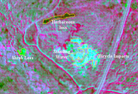
NDVI Difference displayed in Red gun
NIR band Difference displayed in Green gun
Red band Difference displayed in Blue gun
The following images are subsets of 1 meter resolution ADAR imagery collected in 1998 and 1999 at Mission Trails Regional Park. The highlighted yellow areas are known area of change as detected in the imagery and verified by field visits. The first image below was acquired in 1998 and shows two burn areas before the fires and an area which was shown to have increased mustard growth in the 1999 data. The last image is the 1999 imagery of the same area and the change features described are quite obvious. These change features can also be seen on the linked GIS demonstration page below.
1998 image near MTRP visitor's center
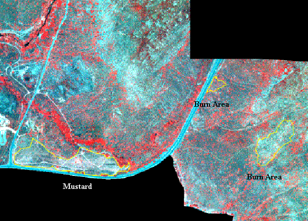
NIR band displayed in red gun
Red band displayed in green gun
Green band displayed in blue gun
1999 image near MTRP visitor's center

NIR band displayed in red gun
Red band displayed in green gun
Green band displayed in blue gun
Follow the Link Below to the GIS Demo for an interactive map of change features.