![]()
![]()
![]()
![]()
![]()
![]()
![]()
![]()
 San Elijo Lagoon is a coastal wetland located in San Diego
County between the cities of Solana Beach and Encinitas, 20 miles north of the
City of San Diego. The watershed draining into the lagoon encompasses 77 square
miles, with two main tributaries; Escondido Creek (72 square miles) and La Orilla Creek (5 square miles). Freshwater inflows to the lagoon are limited by
Lake Wohford and Dixon Lake, in the Escondido Creek Drainage and San Dieguito
Reservoir, in the La Orilla Creek drainage.
San Elijo Lagoon is a coastal wetland located in San Diego
County between the cities of Solana Beach and Encinitas, 20 miles north of the
City of San Diego. The watershed draining into the lagoon encompasses 77 square
miles, with two main tributaries; Escondido Creek (72 square miles) and La Orilla Creek (5 square miles). Freshwater inflows to the lagoon are limited by
Lake Wohford and Dixon Lake, in the Escondido Creek Drainage and San Dieguito
Reservoir, in the La Orilla Creek drainage.
San Elijo Lagoon is formed in a drowned river mouth. Approximately 150 feet of alluvial clay and silts underlay the lagoon basin. Steep bluffs border the lagoon basin and lower reaches of Escondido Creek. These bluffs are composed of tertiary marine sediment deposits of sand, shale and sandstone. The marine sediment formations are predominately Del Mar and Torrey sandstone (from the Mid-Eocene period - 47 million years ago) topped by Linda Vista red sandstone (from the Pliocene-Pleistocene period- 1.6 million years ago). Between 5,000 and 18,000 years ago a period of glacial extremes created ocean level approximately 400 feet below current levels. During the past 1,500 years, the sea level has been relatively stable, although regional studies on the effects of global warming indicate that sea level can be expected to rise by 2-3 ft. during the next 100 years.
Highway 101, the San Diego Northern Railway (SDNR) and
Interstate 5 divide the lagoon into three basins connected by narrow channels.
The west basin, the area between the Pacific Coast Highway (101) and the
railroad, contains 45acres of wetlands that form a series of four to five ponds.
The central 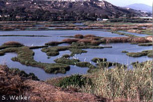 basin between the railroad and Interstate 5 constitutes 200 acres of
shallow open water and mudflats, diked areas formerly used for sewage oxidation
or duck hunting, and a sinuous channel along the northern shore. The east basin,
east of Highway 5 contains approximately 257 acres of shallow fresh and brackish
wetlands, including salt marsh, salt panne, freshwater marsh and riparian
woodland. The basins exhibit the varying salinity regimes and habitats
within the lagoon, generally grading from most saline (>20ppt) in the west
basin, to brackish in the central basin (usually 10-20 ppt) to more or less
fresh in the upper end of the east basin. (In addition to the wetlands, the San
Elijo Lagoon Ecological Reserve includes approximately 300 acres of upland
habitat.)
basin between the railroad and Interstate 5 constitutes 200 acres of
shallow open water and mudflats, diked areas formerly used for sewage oxidation
or duck hunting, and a sinuous channel along the northern shore. The east basin,
east of Highway 5 contains approximately 257 acres of shallow fresh and brackish
wetlands, including salt marsh, salt panne, freshwater marsh and riparian
woodland. The basins exhibit the varying salinity regimes and habitats
within the lagoon, generally grading from most saline (>20ppt) in the west
basin, to brackish in the central basin (usually 10-20 ppt) to more or less
fresh in the upper end of the east basin. (In addition to the wetlands, the San
Elijo Lagoon Ecological Reserve includes approximately 300 acres of upland
habitat.)
![]()