Geographic Information Science and Spatial Reasoning
(GEOG 104) (A General Education [GE] Course) Spring 2018
|
Geographic Information Science and Spatial Reasoning (GEOG 104) (A General Education [GE] Course) Spring 2018
|
|
| Geographic Information Science and Spatial Reasoning (GEOG 104) (A General Education [GE] Course) Spring 2018
|
Geographic Information Science and Spatial Reasoning
(GEOG 104) (A General Education [GE] Course) Spring 2018
This web site is hosted on
MAP.SDSU.EDU
and
Geography Department.
This web site is hosted on
MAP.SDSU.EDU
and
Geography Department.
Geographic Information Science and Spatial Reasoning
(GEOG 104) (A General Education [GE] Course) Spring 2018
Geographic Information Science and Spatial Reasoning
(GEOG 104) (A General Education [GE] Course) Fall 2015
Unit #1.1:
Introduction to Geospatial Information Technology
and Geographic Information Science
1. Welcome and Introduction (Tsou and TAs).
Geospatial Revolution Movie
http://geospatialrevolution.psu.edu
(Trailer and Episode 1)
Textbook: http://www.wiley.com/WileyCDA/WileyTitle/productCd-EHEP001475.html
 |
Geographic Information
Systems and Science , 3rd Edition Paul A. Longley, Michael F. Goodchild, David J. Maguire, David W. Rhind
Published by Wiley |
3. Questionnaires. (Please fill our the questionnaire and return to the instructor)
4. Use the Blackboad for the communication of this course:
5. Facebook "Page" for Geospatial Technology at SDSU: (In Facebook, search "GEOG104")

Blackboard URL: https://blackboard.sdsu.edu/
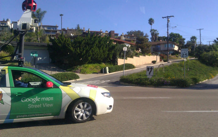
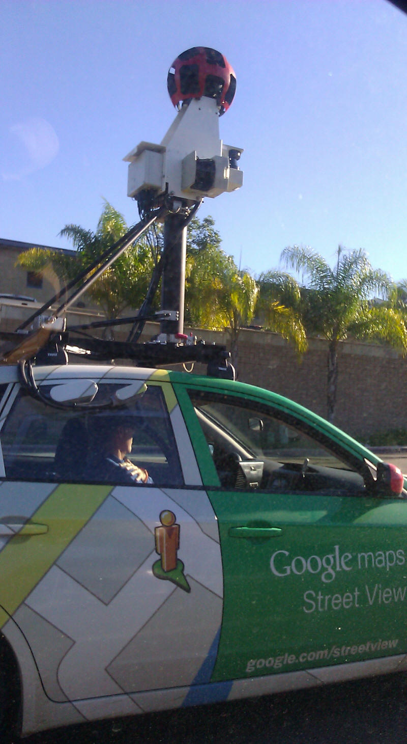
6. Google Map Street View:


2007 Google Street View (Can you recognize your friends?)


(NOTE: Since 2008, Google Map Street View has reduced the resolution of their images significantly to prevent the privacy problems. You will no longer see this high resolution images in Google Map Street View).
WHO is this Guy?
Take a street view from your home address?
Do you have any concerns about the privacy issues with the Street View?
What kinds of applications or business will be useful for using the Street View? (Finding a new apartment location? Shopping?)
Are these images REAL-Time? or Pre-captured? How long will the Google update these images?
Can people take any pictures from the public space (Streets)?
Photos in 2007 ESRI User Conference, San Diego. (Tele Atlas exhibit booth)


Google Map --- Traffic View (Real-time update).
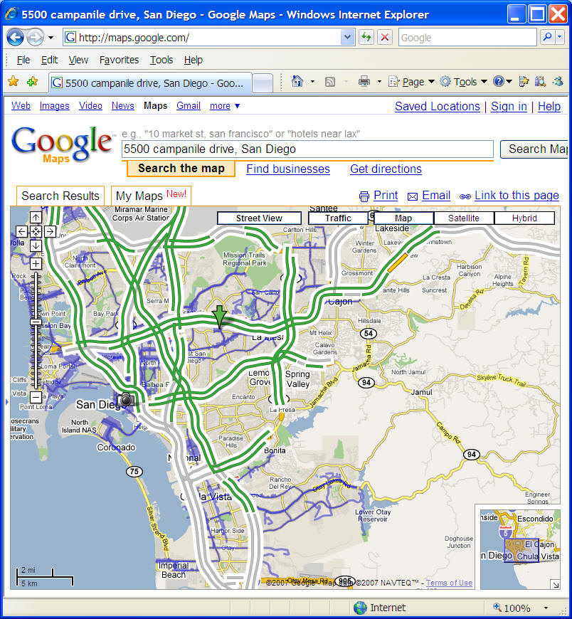
Before the Google Map Street View, there is a A9 Street View product from Amazon.com.

6. Google Earth Bird Flu Example.
A Google Earth Extended (with KML) Map showing the location of the Bird flu (created by Declan Butler (http://declanbutler.info/blog/)
(Note: KML -- Keyhole Markup Language. A computer language for creating customized Google Earth layers.)
Click HERE to open the KML file: http://www.nature.com/nature/googleearth/avianflu1.kml
(Note: you need to download the newest version of google earth to see the different color symbols).
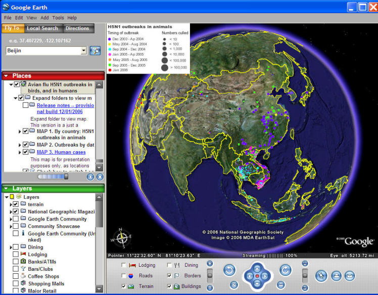
See more information in the following links: http://declanbutler.info/blog/?p=16
Discussion: What is Spatial Reasoning?
Do you see any spatial relationships among these human and animal cases?
If there is a hypothetical bird flu outbreak happen in San Diego... What should we do? Do we have enough hospital?
San Diego Wildfire 2007 and 2014

6. The Article from Nature (Reading Assignment. We will discuss this article next time).
Declan Butler, (2006). The web-wide world. Nature, 439(16). February 2006, pp. 776-778.

7. Text book Reading: Chapter 1.1 Why does GIS matter? (page. 4 - 8).
What do you think GIS can help us with? (Discussion)
Section Two:
(CBS8 Video) - using GIS and social media for disaster responses and assistance - http://www.cbs8.com/story/26835896/sdsu-professor-to-use-twitter-to-alert-san-diegans
Discussion: The role of Social media (Good or Bad?) - http://www.voanews.com/content/murdered-virginia-journalists-much-more-than-what-you-saw-on-tv/2933336.html
1.1 What is the uniqueness of Geographic information? (text book)
What is "Scale"? (tell me your own definition)
1. Scale Dependence: Geographic features at different scales will have different behaviors, different details, and different relationships.
Definition of [Scale]: "The concept of scale is applicable if a system is represented proportionally by another system". (quoted from the Wikipedia http://en.wikipedia.org/wiki/Scale_%28ratio%29) Map Scale: Map items --> Real world items. (1: 1,000).
Map Scale: http://en.wikipedia.org/wiki/Scale_%28map%29 (from the Wikipedia).

In a paper map, the scale is FIXED.
In a computer-based map or a web-based map, the scale is DYNAMIC and changeable.
Different Scale --> Different details: Scale or level of geographic detail is an essential property of any GIS project (textbook, p. 4). (What is "scale" on a map? 1: 10,000)


What are the differences between the three map examples? Different [Scale]? The level of geographic details? What kinds of items are more visible in a larger scale (1:5000)? What kinds of items are more prominent in a smaller scale (1:250,000)?
(Why the 1:5000 is a larger scale comparing to 1:250,000?)
2. Geographic information can be used to solve both scientific questions and practical application problems. With a single collection of tools, GIS is able to bridge the gap between curiosity-driven science and practical problem-solving. (what is the intent of science?)
The Intent of science: The intent for the advancement of human understanding of the world. (textbook: Page. 5).
Which one is more important? (Why vs. How to fix it?)
3. The solution methods of geographic problem can be categorized as operational, tactical, and strategic decisions.
(What are the differences between operational, tactical, and strategic decisions?)
Operational decisions: What do you want to eat tonight ? (Daily)
Tactical decisions: Monthly dinning-out cost should not exceed $300. (short-term).
Strategic decisions: Become more healthy by eating "good" food for the next 10 years. (long-term).
Give an example if an severe Earth Quake hit California, the city mayor needs to perform a few decisions....
Operation decisions?
Tactical decisions?
Strategic decisions?
Unit #1.2
Terminology - 1: (The differences between "geographic information" and "spatial information")
Geographic refers to the Earth’s surface and near-surface (p.8)
Spatial refers to any space --- other planets, human body, DNA, atoms, galaxy, etc. (Google SKY view demo).
Geographic + Spatial = Geospatial (?) implying a subset of spatial applied specifically to the Earth’s surface and near-surface.
Discussion: (Why use the new term?) What's the advantages and disadvantages of using the new term "Geospatial"?
Reminder: Read the Nature Article (we will discuss it next week).
Geographic Information Systems --> Converting -- data --> information --> Knowledge --> ???
1.2 Data-Information-Knowledge transformation (text book)
 (image
source:
http://code.ucsd.edu/Images/brain-1.jpg )
Examples: Global Warming Effect (note: Pseudo data used in this example)
Data -- collect annual temperature at San Diego from 1990 to 2006 (create a databases) (54, 55, 53, 56 …… 57)
Information -- convert the raw data into a Graphic bar chart from 1990 to 2004
Evidence -- collect other city’s annual temperature (New York, Chicago, Dallas, Tokyo, London, etc.) All cities indicate an increase of annual temperature.
Knowledge -- Why did the temperature increase? The increase of CO2, the balance of solar energy, etc.
Wisdom -- Decision makers can make laws to reduce the production of CO2 and also balance the economic growth.
http://www.climatehotmap.org/index.html

http://zebu.uoregon.edu/1998/es202/l13.html (Greenhouse Effect )
What are the differences between "Global Warming" and "Climate Change"?
Public Opinion Survey:
http://environment.yale.edu/poe/v2014/

Terminology # 2:
GIS or GISystems: Geographic Information Systems (tools, software, hardware).
GIScience: Geographic Information Science (Scientific research domain).
GIServices: Geographic Information Services (Web-based services).
Geographic Information Systems (GIS)
GIS solves the problem of combining general scientific knowledge (classification, rule sets, modeling) with specific information (local GIS databases) and gives practical value to both.
Many geographic problems involve multiple goals and objectives, which often cannot be expressed in commensurate terms. (Longley, et al. p. 16).
Everyone has their own favorite definition of a GIS.
The six component parts of a GIS: (from a community perspective)
Examples: San Diego Web GIS for Older Adult Services
http://mappingideas.sdsu.edu/health/viewer/


Can you tell what are the six components of GIS in the San Diego Web GIS for Older Adult Service Maps?
From a Functional Perspective: GIS has five elements:
Data Input
Database/Information Storage
Information Analysis
Data/Information Sharing
Information Output

(One missing line in the above figure... Can you guess which line?)
Information Output examples: Google Mashup Maps:
CraigList example: Housing Maps: http://www.housingmaps.com/

What is Geographic Information? Why is it important?
Geographic Information is a special class of information -- comparing to tabular information, graphic information, numbers, texts, etc.
Over 50% of information contains "geographic" or "spatial" meanings:
Your home address: 888## Lake Murray Blvd, San Diego, CA 92142.
Your phone number: (619) 123-4567. --->
Where? (Try to use
"White Page"
http://www.whitepages.com/
to search for your home
phone number...)
Your tuition fee (In-state vs. out-of-state status).
When and where did you use your credit card ? (Why?) (If you spend $5000 tomorrow at a New York Shopping Mall with your local address at San Diego, you might get a warning phone call from the Credit Card Company.) --- Geographic Information can be explicit or inexplicit!
Geographic Information can SAVE TIME!
Example 2: Create a Shortest School Bus Routing.
Merced, California, School District Uses GIS for Special Education School Bus Routing
"We wanted a program where we could have 'hands-on' in setting up the routing for several reasons," "For one, medically fragile children need to go home first, even if they are the last person on the route. We needed to be able to interact with the program and do our own 'connecting dot to dot' or setting the order of students." -- Merle Jewett. (from On-line ArcNews).
http://www.esri.com/news/arcnews/fall02articles/merced-school.html

Geographic Information can SAVE LIVES!!!
Example 3: The First Few Minutes – GIS Can Help Save Lives (By Vicki Schmidt)
http://www.state.me.us/newsletter/oct2004/first_few_minutes_.htm
(E-911: Enhanced 911 Services)
http://www.fcc.gov/911/enhanced/
The wireless E911 program is divided into two parts - Phase I and Phase II. Phase I requires carriers, upon valid request by a local Public Safety Answering Point (PSAP), to report the telephone number of a wireless 911 caller and the location of the antenna that received the call. Phase II requires wireless carriers to provide far more precise location information, within 50 to 300 meters in most cases.

Discussion: The REVERSE 911 Service during San Diego 2007 Wildfire...
Does it work? What is REVERSE 911?
http://en.wikipedia.org/wiki/Reverse_911
REVERSE 911® is a communications solution that uses a patented combination of database and GIS mapping technologies to deliver outbound notifications.
Problems: IP phones and cellular phones... (So ? You need to register your cellular phone with your LOCATION!)
http://www.readysandiego.org/alertsandiego/

National Research Council of the National Academy of Science (NAS), Committee on Geotargeted Alerts and Warnings: A Workshop on Current Knowledge and Research Gaps. Committee member, 2012- Current. (Research gap analysis for Department of Homeland Security and FEMA). http://www8.nationalacademies.org/cp/CommitteeView.aspx?key=49491
CMAS (Commercial Mobile Telephone Alerts) http://transition.fcc.gov/pshs/services/cmas.html
Wireless Emergency Alerts (WEA) http://www.nws.noaa.gov/com/weatherreadynation/wea.html#.Uh7kKRtwrmc


Problems and Challenges with CMAS and WEA (not very good at "geo-targetting")
(Discussion)
What is the field of Geographic Information Science?
Geographic Information Science is a big umbrella, which covers many topics....
Remote Sensing:
http://rst.gsfc.nasa.gov/Intro/Part2_1a.html (Remote Sensing Tutorial)
 (image source: Nicholas M. Short, Sr., The
Remote Sensing Tutorial,
http://rst.gsfc.nasa.gov/Intro/Part2_1a.html )
 (image source: Nicholas M. Short, Sr., The
Remote Sensing Tutorial,
http://rst.gsfc.nasa.gov/Intro/Part2_1a.html )
http://earthobservatory.nasa.gov/ (NASA Earth Observatory Systems Website).
http://earthobservatory.nasa.gov/Study/GreenRoof/ (Examples)
http://earthobservatory.nasa.gov/Observatory/Datasets/rainfall.gpcp.html (Create animation for Rainfall). (You need to enter both the months and years info to create a movie).


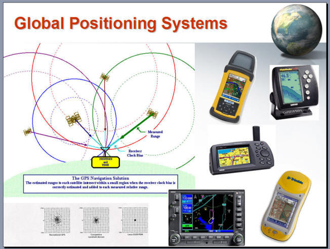
GPS (Global Positioning Systems.)
Spatial Statistics and Spatial Modeling
Crime Mapping http://www.ncjrs.gov/pdffiles1/nij/209393.pdf


Cartography (Map Design)

ARJIS (San Diego Crime Mapping Project). http://mapping.arjis.org/

http://www.crimemapping.com/map.aspx?aid=137a7b29-7112-471f-9d43-728ca7ec478f
(New Crime Mapping)

Historical Crime Data in San Diego: San Diego Regional Data Library http://www.sandiegodata.org/

Do you know which street or location has the highest crime records in San Diego?
Movies: 2005 Nov. 30, KUSI News9 Visit CESAR lab or the new CBSNews Movie)
WMV version (28Mb)
In-Class Discussion (prepare to share your answers in the beginning of next session).
1. Please describe one example of "inexplicit" geographic information from a physical or virtual item (such as a toy box?, a TV show, a pen, etc.) used in your daily activities.
2. Please find one website of real-world applications or projects related to the domain of GIScience (including remote sensing, GPS, and spatial statistics/modeling). and tell us the URL of the website. You can share your examples in the Facebook Page if you like (optional).
This web site is hosted on MAP.SDSU.EDU
and Geography Department.
This web site is hosted on
MAP.SDSU.EDU
and
Geography Department.
|
|