
|
|
|
|
|
|
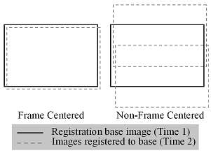
The project team developed and tested a method which enables precise spatial registration between multitemporal, high resolution aerial imagery. The approach is referred to as frame center (FC) matching for mutltitemporal image registration. Two acquisition components of the frame center matching approach are: 1) geometric control by matching camera stations in terms of horizontal position and altitude, and 2) radiometric control (normalization) by matching sun- scene-sensor geometry. Geometric matching is most effectively accomplished through the use of global positioning systems (GPS) to trigger image capture at the same camera station previously visited during the first multitemporal pass. However, in the absence of a GPS-based sensor triggering system, frame centers may be matched if velocity, camera triggering intervals, and initial exposure station are successfully controlled. Figure 9 illustrates the relative spatial position of FC matched and non-frame center (NFC) matched multitemporal image sets. Radiometric control is based upon timing image acquisition so that the solar azimuth and zenith angles are as similar as possible to previous acquisitions, reducing differences in terrain related radiometric variability, feature shadows, anisotropic reflectance (including hot spot) effects, and magnitude of solar illumination. |
|||||||||||||
|
|||||||||||||
|
Position of frame center and non-frame
center matched images |
|||||||||||||
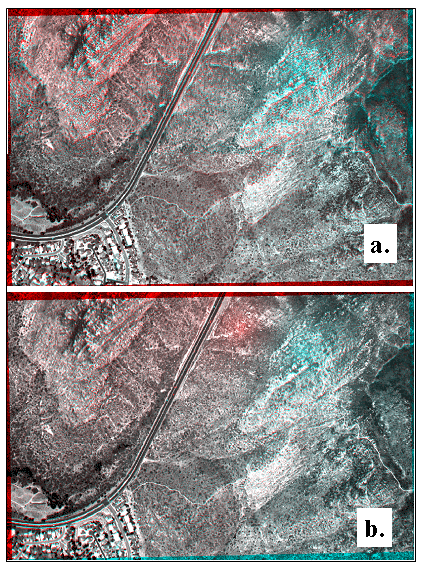
| The improvement in registration accuracy can be seen in overlay composite images of registered multitemporal NFC and FC image frames acquired during the multiple passes along the single flightline on 29 June 2001. | |||||||||||||
|
Red waveband overlay composites of image
frames registered with (a) non-frame center and (b) frame center matched
registration approaches. Second-order polynomial warping was performed
with DIME. The illustrated non-frame center composite (a) was created
by graphically aligning and joining two non-frame center registered image
sets, so that results for the same extent as the frame center registration
(a) are shown. |
|||||||||||||
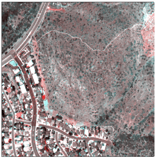
| The utility of FC matched acquisition and registration for detailed change detection analysis can be seen in Figure 11. For this change detection product, single image frames acquired with matching frame center positions in 1998 and 1999 were registered using second order polynomial warping, with little apparent misregistration. Red colors in Figure 11 indicate an increase in brightness between 1998 and 1999, while cyan indicates a decrease in brightness over time. Phenological differences in individual shrub canopies, mechanical clearing (upper left), and fire (upper right) are apparent within the shrubland. In the urban portions of the change product, re-roofing of houses, tree removal, and differences in vehicle locations on the roads are highlighted. | |||||||||||||
|
Change detection product derived from 1998 and 1999 frame center matched ADAR images registered using a second-order polynomial warping algorithm. The 1999 red waveband is displayed in the red color plane, while the 1998 waveband is displayed in the blue and green color planes. |