|
|
|
|||||||||||||||||||
|
|
||||||||||||||||||||
 |
|
|
||||||||
| This website describes remote sensing research conducted by the Department of Geography at San Diego State University in support of San Diego's Multiple Species Conservation Program (MSCP). The MSCP was developed by the City and County of San Diego in support of the Natural Community Conservation Plan (NCCP) for five southern California counties. The NCCP is a novel and prototypical habitat management effort. Wildlife agencies, landholders, city governments, developers, and environmentalists designed the habitat reserve system with designated developable | ||||||||||
|
lands. San Diego's MSCP complies with all NCCP criteria and is designed to preserve natural habitat for threatened and endangered plants and animals in the county while still allowing for future urban development. The objective of this research was to develop and implement remote sensing technologies which enabled complete coverage and repetitive observations of habitat conditions within San Diego's MSCP reserve areas. The information on this website is intended to help local governments and private landholders to establish management policies to better manage habitat reserves. This project was funded by National Aeronautics and Space Administration (NASA) and Food and Fiber Applications of Remote Sensing (FFARS). Additional partners in this effort include; the City of San Diego, the County of San Diego, Conservation Biology Institute, California Department of Fish and Game, Ed Almanza & Associates, and Mission Trails Regional Park Rangers. |
||||||||||
|
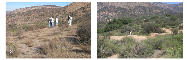
Disturbance from a) mechanical clearing
and b) Biking-Motocross (BMX) within Mission Trails Regional Park. |
||||||||||