Multiple Species Conservation Program (MSCP) Habitat Monitoring: Remote Sensing Research at San Diego State University
|
|
Multiple Species Conservation Program (MSCP) Habitat Monitoring: Remote Sensing Research at San Diego State University |
Objectives and Approach
The primary objective of this study is to develop, test, and transfer remote sensing and other geo-spatial technologies for monitoring the amount, condition and quality of wildlife habitat within reserve systems being established throughout southern California. In the context of regional and reserve-level monitoring of habitats in southern California with visible and near-infrared (VNIR) data and assuming that the primary elements of habitat for key, rare and endangered animal species that are likely to be remotely sensed pertain to vegetation, the following research questions will be explored through this proposed study:
1) What features or characteristics of
vegetation constitute the quality and/or condition of habitat?
2) What types of disturbances to habitat and associated responses of
vegetation are likely to occur within the NCCP reserves and how are they
manifested on high resolution VNIR imagery?
3) Which derivatives of VNIR data (e.g., spectral vegetation indices,
vegetation, cover mixtures, spatial pattern indices of these derivatives) most
closely relate to variations in habitat quality/condition and responses to
disturbances?
4) What aspects of changing habitat quality/condition and human disturbances
(e.g., plant invasions, recreational impacts and development) can be monitored
using VNIR data at 4 m and 0.5 - 1.0 m ground sampling distances?
5) Is spatial variability in habitat quality a useful surrogate for testing
the development of change detection techniques that are applicable to
detecting temporal variability in habitat quality?
6) In terms of plant phenologies and VNIR spectral signatures, what is the
optimal time of year for interannual assessments of habitat changes?
7) What will be the benefit to reserve managers and resource agency personnel
of having habitat monitoring information derived from remote sensing, relative
or in addition to ground-based sampling programs that are currently planned?
8) How useful is the technical monitoring approach for management of other
habitat types and other resource management applications (e.g., watershed
hydrology, fire management, and agriculture)?
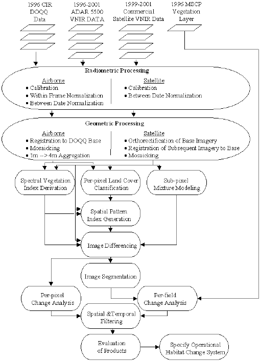
To help answer the above questions, this project is performing advanced pre-processing and change detection with airborne and satellite image data. Vegetation maps within existing GIS databases are also being utilized to evaluate per-field changes in habitat condition and quality. The data processing logic applied by the project is displayed in the following diagram.