Unit-13 

Geographic Information Science and Spatial Reasoning

(GEOG 104)  (A General Education [GE]  Course)  Spring 2018

horizontal rule

Back Home

  Unit-13 

Geographic Information Science and Spatial Reasoning

(GEOG 104)  (A General Education [GE]  Course)  Fall 2015

horizontal rule

Back Home


Unit 13 

The Future of Geospatial Information Technology

horizontal rule


GISystems and GIScience

bullet

"Geographic information systems support and drive GIScience.” (textbook pp 472) bullet

bullet

“Geographic information science drives the development of GISystems.” (textbook pp 474)


The Future of GIS


Extreme Technology


Figure 12. Smart Dust

 (http://robotics.eecs.berkeley.edu/~pister/SmartDust/)


The Columbia Supercomputer at NASA's Advanced Supercomputing Facility at Ames Research Center

Figure 13. A Supercomputer at Ames Research Center

(http://en.wikipedia.org/wiki/Image:Columbia_Supercomputer_-_NASA_Advanced_Supercomputing_Facility.jpg )


Cal-IT2  California Institute for Telecommunications and Information Technology

http://www.calit2.net/index.php

November 10, 2008
Scalable City Trailer
Exploring the Link Between Digital and Literary Art
Speaker: Sheldon Brown, Calit2 Artist in Residence, Director, UCSD Center for Research in Computing and the Arts
[news release]
[video]Length: 4:04

Scalable City Trailer

The Highly Interactive Parallelized Display Wall project (HIPerWall)  http://cg.calit2.uci.edu/mediawiki/index.php/Research_Projects:_HIPerWall


Sensor Web 

http://en.wikipedia.org/wiki/Sensor_Web

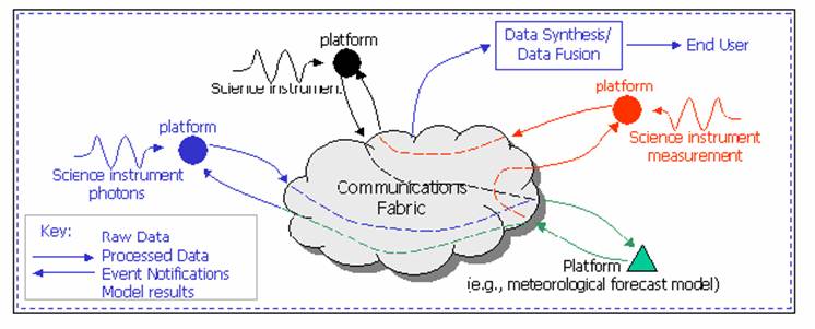
(cited from Wikipedia)  The Sensor Web is a type of sensor network or geographic information system (GIS) that is especially well suited for environmental monitoring and control. In 1997, Kevin Delin of NASA's Jet Propulsion Laboratory used the term to describe a specific type of sensor network: an amorphous network of spatially distributed sensor platforms (pods) that wirelessly communicate with each other. This amorphous architecture is unique since it is both synchronous and router-free, making it distinct from the more typical TCP/IP-like network schemes. The architecture allows every pod to know what is going on with every other pod throughout the Sensor Web at each measurement cycle.


Figure 14.  Sensor Web (http://aaaprod.gsfc.nasa.gov/sensorweb/)

 http://www.technologyreview.com/read_article.aspx?id=16781&ch=infotech


http://hpwren.ucsd.edu/news/021115.html


Visualization

Figure 15. IBM Open Visualization Data Explorer

 (http://www.research.ibm.com/dx/)


New Research Direction of Internet GIS

bullet

Download PDF file

bullet

Download PPT file

New Research Direction of Internet Mapping


Grid Computing and Semantic Web.

PowerPoint slides created by Tong Zhang.

(Download PDF files here)


GIS Applications

The most popular, successful and promising areas:

l       Homeland security and geo-spatial intelligence (Fig. 16);

l       Anti-crimes (Fig. 17);

A list of crime analysis tools (http://www.iaca.net/Software.asp)

l       Public health (Fig. 18);

l       Environment and natural resource management (Fig. 19);

l       Transportation (Fig. 20);


The Future Directions of GIS


Multiple versions from various institues.


UCGIS 1996

bullet

Spatial Data Acquisition and Integration;

bullet

Distribute Computing; Extensions to Geographic Representations;

bullet

Cognition of Geographic Information; Interoperability of Geographic Information;

bullet

Scale;

bullet

Spatial Analysis and Modeling in a GIS Environment;

bullet

The Future of the Spatial Information Infrastructure;

bullet

Uncertainty in Geographic Data and GIS-based Analyses; GIS and Society.


UCGIS 2004

Spatial Data Acquisition and Integration; Cognition of Geographic Information; Scale; Extensions to Geographic Representations; Spatial Analysis and Modeling in a GIS Environment; Research Issues on Uncertainty in Geographic Data and GIS-Based Analysis; The Future of the Spatial Information Infrastructure; Distributed and Mobile Computing; GIS and Society: Interrelation, Integration, and Transformation; Geographic Visualization; Ontological Foundations for Geographic Information Science; Remotely-Acquired Data and Information in GIScience; Geospatial Data Mining and Knowledge Discovery.

David Mark (SUNY-Baffalo) bullet

GIS Data Integration; bullet

Scale; bullet

Process Models; bullet

Usability; bullet

Representation; bullet

Uncertainty; bullet

Cognition; bullet

Simulation; bullet

Data Collecting.


GIS textbook (Longley, Goodchild, Rhind)

Ten Grand Challenges for GIS

  1. Global Data Layers;

  2. The GIS Profession;

  3. The GIS Curriculum;

  4. Near-universal Empowerment;

  5. Global Population Statistics;

  6. Richer Geodemographic Data Infrastructure;

  7. Ego-centered Mapping;

  8. Comprehensive Data Models;

  9. Balancing of Fighting Terrorism and Maintaining Lifestyles;

  10. Richer Geo-simulation;


National Research Council (2003).  IT Roadmap to a Geospatial Future


bullet

Location-aware Computing;  bullet

Geospatial Databases and Data Mining; bullet

Human Interaction with Geospatial Information; bullet

High-quality Geospatial Information.


 [1] UCGIS (via R. McMaster). (1996). Research Priorities for Geographic Information Science. Cartography and Geographic Information Systems, 23 (3), 115-127, 1996.

[2] Mark, D.M. (2000). Geographic Information Science: Critical Issues in an Emerging Cross-Disciplinary Research Domain. Workshop Report, Workshop on Geographic Information Science and Geospatial Activities at NSF. January 14-15, 1999.URISA Journal 12(1): 45 – 54.

[3] National Research Council (2003).  IT Roadmap to a Geospatial Future. National Academies Press., Washington, DC. (Available at http://www.nap.edu/catalog/10661.html)

[4] McMaster, R., and User, E. L. (2004). A Research Agenda for Geographic Information Science. Taylor & Francis. http://www.ucgis.org/priorities/research/2006ResearchNextSteps.htm


Discussion:

What is your own vision for the future of GIS?

horizontal rule


horizontal rule

Back Home


horizontal rule

  
This web site is hosted on MAP.SDSU.EDU
and Geography Department.

horizontal rule

  
This web site is hosted on MAP.SDSU.EDU
and Geography Department.