
![]()
![]()
![]()
![]()
![]()
![]()
![]()
![]()
![]()
Project Introduction
Project Objective
Project Task
Technical Issue
Market Phasing
Image
Overlay
Image Swipe
Image Magnifier
Image Comparison
Image Processing
Image Viewing
Panoramic
Image


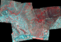
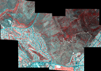
The images to the left are mosaics of Airborne Data Acquisition and Registration (ADAR) 5500 image frames acquired from a fixed wing aircraft in June of 1998 and May of 1999. They have a ground resolution element of 1 meter, which means that you can see objects that are approximately 1 meter across or greater. Cars and swimming pools are readily apparent. The ADAR digital cameras capture electromagnetic radiation in blue, green, red, and near-infrared wavebands. The near-infrared waveband is just outside of the visible range, and provides a lot of information about vegetation condition. The image frames were georeferenced using a 3 foot resolution digital orthophotographic image as a base map.
Image Source: SDSU CESAR Lab


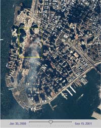
Pre and Post-Attack on America
The left are two overlay one-meter resolution satellite images that prominently features the lost World Trade Center. Top image was collected June 30, 2000 by Space Imaging's IKONOS satellite. Bottom image was taken at 11:54 a.m. EDT on Sept. 15, 2001. It shows the remains of the 1,350-foot towers of the World Trade Center, and the debris and dust that has settled throughout the area. Also visible are the many emergency and rescue vehicles in the streets in the vicinity of the disaster.
Image courtesy of SPACE IMAGING ©
http://www.spaceimaging.com/
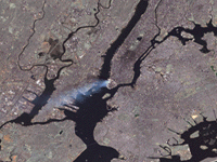
Aftermath of World Trade Center, New York
This true-color image was taken by the Enhanced Thematic Mapper Plus (ETM+) aboard the Landsat 7 satellite on September 12, 2001, at roughly 11:30 a.m. Eastern Daylight Savings Time, which shows a large plume of smoke streaming southward from the remnants of the burning World Trade Towers in downtown Manhattan yesterday (September 11, 2001).
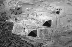
This one-meter resolution black-and-white image of Giza, Egypt was collected November 17, 1999 by Space Imaging's IKONOS satellite. The image features the Great Pyramid, built by King Snefru's son, Khufu, and the Sphinx, a massive statue of a lion with a humanhead.aaaaaaaaaaaaaaaaaa
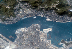
This four-meter color image of Hong Kong, China was collected November 21, 1999 by Space Imaging's IKONOS satellite. The image features the Hong Kong Convention and Exhibition Center, Bank of China and Star Ferry Pier. aaa
Copyright 2001 All right reserved