
»
Quick Links
•
Mission Statement
•
Technical Approach
•
Related Opportunity

![]()
This
project involves three technical issues, to be resolved through the following
approaches:
Establish a working example for the integration of mobile GIS applications.
The mobile devices will have the integrated capabilities of GPS, GIS,
and remote sensing. Web-based mapping facilities can be integrated with
wireless mobile devices and GPS. Currently ESRI’s ArcPAD is the pocket-size
GIS software which can be used in this research. Also, Microsoft provides
several free development tools for mobile and embedded applications under
their .NET framework, such as the Microsoft Mobile Internet Toolkit (MMIT).
MMIT adopted Wireless Markup Languages and compact HTML (cHTML) which
can be applied for mobile devices.
The
following figure illustrates a possible working example of one such mobile
GIS solution. In this example, an Internet map server is installed on
a notebook computer with wireless access port. The notebook and wireless
access port will be placed inside a vehicle to provide power for wireless
communication. Field workers can use Pocket PC’s with GPS and a wireless
card to access large remote-sensing imagery and GIS data from the server
via Wi-Fi communication channel. The whole system is mobile and suitable
for various environmental monitoring tasks.
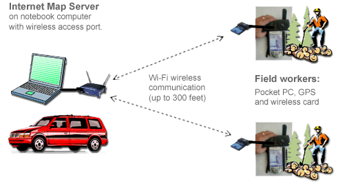
Figure 1. Wireless Local Network Solution for Mobile GIS
Enhance web-based mapping functions by combining ESRI ArcIMS and ER Mapper
Image Web Server. ESRI’s Internet Map Server (ArcIMS) only focuses
on GIS query and identification functions and was not originally designed
for the display of remote sensing images. There is a significant limitation
for adding remote sensing image layers into ArcIMS under current software
architecture, such as image size and formats. ER Mapper’s Image Web
Server utilizes the power of the patented ECW Wavelet compressed image
format, which can stream terabyte-sized (1000GB+) images directly to servers
and generate client-size images efficiently. The Image Web Server browser
clients can dynamically integrate imagery from the server with GIS layers
from a range of WebGIS solutions, including ESRI ArcIMS. The client-side
image viewing functions and performance will be significantly improved
by combining ArcIMS and Image Web Server (Figure 2).
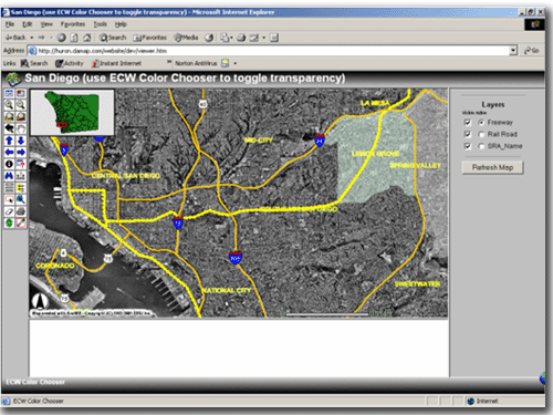
Figure
2. An integrated Image Web Server/ArcIMS® site created with
ArcIMS® Designer and I-Wizard (Picture provided by ER Mapper)
Add
image input/output and geoferencing capabilities to the current Java applets.
The Java programming languages provide comprehensive API for the file
managements, especially in the Java.io package. The Java.io package includes
several useful functions, such as FileFilter, RandomAccessFile, DataInput,
DataOutput API. For the georeference function, this project will use ESRI’s
world file to georeference remotely sensed imagery for Java applets. The
following is an example of world files.
An example of world file contents
20.17541308822119 (A)
0.00000000000000 (D)
0.00000000000000 (B)
-20.17541308822119 (E)
424178.11472601280548 (C)
4313415.90726399607956 (F)
A = x-scale; dimension of a pixel in map units in x direction
E = negative of y-scale; dimension of a pixel in map units in y direction
B, D = rotation terms
C,
F = translation terms; x,y map coordinates of the center of the upper-left
pixel