![]()

About 3,000 years ago 100 or less Native Americans lived in the Otay River Watershed at "La Punta". Archeologists think they lived there year round, because they had water all the time in the Otay River. The Otay River watershed had plentiful plants which grew wild, acorns from oak trees within traveling distance, shell fish, amphibians, birds and mammals. They also could get grains from the native grasses.
The healthy wetlands along the Otay River had no problems at that time.
During the mission period, perhaps, some cattle were grazed in the Otay area. The cattle could be left totally on their own to eat and grow.
After the Mexican Revolution in 1810, California became part of Mexico. Some retired soldiers wanted the land of the missions. Janal, Otay, La Punta, and De La Nacion ranches were granted to people. A few more cows were bought to the Otay Valley.
When the cattle were introduced, they brought alien seeds, which soon took over in the Otay Watershed, replacing the slower growing native grasses.
In 1849 gold was discovered in California. Hunderds of thousands of people came to California every year. Although most of the people went to northern California, some people came down to San Diego.
In the 1870's and 80's, the farms of Otay Mesa, South Chula Vista and the Tijuana River Valley were mostly growing grains. The town of Otay was a small market town for these farms.
The population in 1891 was around 400 people. In 1887, a man named Babcott constructed a dam at Lower Otay Lakes. Later on, he built another dam at Upper Otay Lakes.
On January 27, the dam broke and the flood wiped out the town of Otay and all the farms. They didn't rebuild Otay. People continued farming through out the depression. Truck farms dominated until the 1870's. Back then Montgomery High School was a tomato field.
Over the years, all these changes affected the Otay River watershed and the river it self. When Babcott built the dam, the river no longer flowed except when it rained. Many plants, fish, and amphibians died, and other animals left. Agriculture and the cattle as well as the mining destroyed the wetlands, and many alien plants started to grow all over the watershed. Mining in the Otay River left large holes which are now ponds: some have water all year but some have water only when it rains. These ponds now support what is left of the plants, some fish, and animals.
Today there still are agricultural and construction sites that affect the water. There are also 135 recycling related industries (auto wreckage, metal recycling centers, landfills, etc.) , an auto park, an industrial park, cement companies and gravel mining, but the main non point source pollutants are not these companies but the people in general.
There are policies that regulate what goes into the river, but it is hard to control everything that goes into it. That is why we need to learn what things contaminant the Otay River.
METADATA SECTION
IDENTIFICATION INFORMATION:
ORIGINATOR: Tierra Data Systems
PUBLICATION DATE: 19940101
TITLE: WSBOUND
EDITION: UNKNOWN
GEOSPATIAL DATA PRESENTATION FORM: Digital Coverage
PUBLICATION INFORMATION:
PUBLICATION PLACE:Unknown
PUBLISHER:Unknown
ONLINE LINKAGE:Unknown
LARGER WORK CITATION:
ORIGINATOR:San Diego Association of Governments (SANDAG)
PUBLICATION DATE:19940101
TITLE:wsbound
PUBLICATION INFORMATION:
PUBLICATION PLACE:San Diego, CA
PUBLISHER: San Diego Association of Governments (SANDAG)
ONLINE LINKAGE:WWW.SANDAG.COG.CA.US
DESCRIPTION:
ABSTRACT:
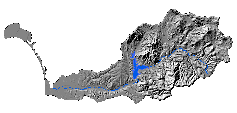
**This coverage contains the Otay Watershed Boundary. It was
selected from the Larger Work Source Map titled "Hydorlogic Basins".
This data was mapped at 7.5 Quad scale and has a finer resolution
than the old hydrologic basin data that was mapped at 1:500,000. These
hydrobasins were mapped for the CDF under specifications provided by
the Department of Water Resources. The original coverage from Tierra Data
Systems contained the hydrologic basins for the Southern California region
and was in the Albers projection. It has been re-projected to California
State Plane, NAD83.
This version contains whole hydrologic sub-area polygons, i.e. any subarea
which crosses the San Diego boundary is included.
Data has been reviewed and accepted by USGS and Soil Conservation Service (SCS).
PURPOSE: A multi-coverage database has been developed for the
Otay watershed. The original watershed boundaries were derived
from SANDAG Data which delineated all watersheds within the county. Each
coverage theme was clipped to a buffered boundary of the Otay
watershed. Buffer distance used was 1000 meters. The intent of the
database is to provide a introductory tool for analysis of multifarious
data themes in the watershed.
SUPPLEMENTAL INFORMATION:
RANGE OF DATES/TIMES
BEGINNING DATE:Unknown
ENDING DATE:19940101
CURRENTNESS REFERENCE: Publication date
STATUS:
PROGRESS:Complete
MAINTENANCE AND UPDATE FREQUENCY: Unknown
SPATIAL DOMAIN:
BOUNDING COORDINATES:
WEST: 1785957
EAST: 1850242
NORTH: 6419400
SOUTH: 6260941
Projection STATEPLANE
Zone 3401
Datum NAD83
Units FEET
Spheroid GRS1980
ACCESS CONSTRAINTS:None
USE CONSTRAINTS:Not for legal use
POINT OF CONTACT:
CONTACT ORGANIZATION PRIMARY:SANDAG
ADDRESS:401 B Street, Suite 800,
CITY: SAN DIEGO
STATE: CA
POSTAL CODE:92101
COUNTRY:USA
CONTACT VOICE TELEPHONE:619-595-530
CONTACT FACSIMILE TELEPHONE: 619-595-5305
CONTACT ELECTRONIC MAIL ADDRESS:WWW.SANDAG.COG.CA.US
HOURS OF SERVICE:M-F 9-5pm
NATIVE DATA SET ENVIRONMENT: ARC/INFO
METADATA SECTION 7:
METADATA REFERENCE INFORMATION:
METADATA DATE:1999
METADATA REVIEW DATE:1999
METADATA CONTACT: San Diego Association of Governments (SANDAG)
ADDRESS:401 B Street, Suite 800,
CITY: SAN DIEGO
STATE:CA
POSTAL CODE:92101
COUNTRY:USA
CONTACT VOICE TELEPHONE:619-595-530
CONTACT FACSIMILE TELEPHONE: 619-595-5305
CONTACT ELECTRONIC MAIL ADDRESS:WWW.SANDAG.COG.CA.US
HOURS OF SERVICE:M-F 9-5pm
METADATA STANDARD NAME:UNKNOWN
METADATA STANDARD VERSION:UNKNOWN
ADDITIONAL INFORMATION:
SOURCE MAPPING SCALE: 1:24,000
FEATURE TYPE: polygon
