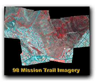
1998 Mission Trail ADAR Imagery
FGDC Standard Format http://www.fgdc.gov/metadata/metadata.html
Metadata:
- Identification_Information:
- Citation:
- Citation_Information:
- Originator: Department of Geography at San Diego State University
- Publication_Date: Fall 2001
- Title: 98_mt_final_mos.img
- Abstract:
- Four band ADAR 5500 image mosaic of southeast portion of Mission Trails Regional Park. Imagery was acquired on June 27, 1998.
- Purpose:
- Produced by the Department of Geography at San Diego State University for the purpose of documenting ground cover conditions and evaluating change over time.
- Supplemental_Information:
- This imagery was acquired by Positive Systems. The Department of Geography at San Diego State University corrected the imagery for across-frame anisotropic reflectance, georeferenced and orthorectified the imagery using ERDAS Imagine Orthobase, and mosaicked the individual image frames to create a single image. The projection is State Plane, NAD83, GRS80, Zone 3401 (Cal VI), and units are feet. The ADAR wavebands are blue (450-540 nm), green (520-600 nm), red (610-690 nm), and near-infrared (780-1000 nm). The spatial resolution is 3.28084 ft (1 m).
- Time_Period_of_Content:
-
- Time_Period_Information:
-
- Single_Date/Time:
-
- Calendar_Date: June 27, 1998
- Currentness_Reference: Imagery acquired June 27, 1998
- Status:
-
- Progress: Image mosaic is complete
- Point_of_Contact:
-
- Contact_Information:
-
- Contact_Person_Primary:
-
- Contact_Person: Douglas A. Stow
- Contact_Organization: Department of Geography at San Diego State University
- Contact_Position: Professor of Geography
- Contact_Address:
-
- Address: 5500 Campanile Drive
- City: San Diego
- State_or_Province: CA
- Postal_Code: 92182-4493
- Country: USA
- Contact_Voice_Telephone: (619) 594-5498
- Contact_Facsimile_Telephone: (619) 594-4938
- Contact_Electronic_Mail_Address: stow@mail.sdsu.edu
- Hours_of_Service: 9:00AM - 5:00PM
Description: