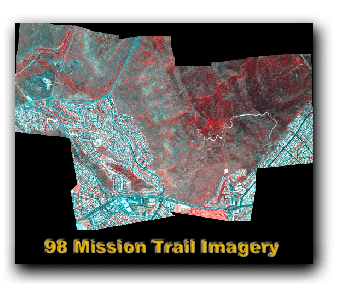
1998 Mission Trail ADAR Imagery
FGDC Standard Format http://www.fgdc.gov/metadata/metadata.html
Metadata:
- Identification_Information
- Spatial_Data_Organization_Information
- Spatial_Reference_Information
- Entity_and_Attribute_Information
- Distribution_Information
- Metadata_Reference_Information
- Identification_Information:
-
- Citation:
-
- Citation_Information:
-
- Originator: Department of Geography at San Diego State University
- Publication_Date: Fall 2001
- Title: 98_mt_final_mos.img
- Geospatial_Data_Presentation_Form: remote-sensing image
- Online_Linkage: \\ESKER\f\liang\98_mt_final_mos.img
- Description:
-
- Abstract:
- Four band ADAR 5500 image mosaic of southeast portion of Mission Trails Regional Park. Imagery was acquired on June 27, 1998.
- Purpose:
- Produced by the Department of Geography at San Diego State University for the purpose of documenting ground cover conditions and evaluating change over time.
- Supplemental_Information:
- This imagery was acquired by Positive Systems. The Department of Geography at San Diego State University corrected the imagery for across-frame anisotropic reflectance, georeferenced and orthorectified the imagery using ERDAS Imagine Orthobase, and mosaicked the individual image frames to create a single image. The projection is State Plane, NAD83, GRS80, Zone 3401 (Cal VI), and units are feet. The ADAR wavebands are blue (450-540 nm), green (520-600 nm), red (610-690 nm), and near-infrared (780-1000 nm). The spatial resolution is 3.28084 ft (1 m).
- Time_Period_of_Content:
-
- Time_Period_Information:
-
- Single_Date/Time:
-
- Calendar_Date: June 27, 1998
- Currentness_Reference: Imagery acquired June 27, 1998
- Status:
-
- Progress: Image mosaic is complete
- Maintenance_and_Update_Frequency: None planned
- Spatial_Domain:
-
- Bounding_Coordinates:
-
- West_Bounding_Coordinate: -117.062008
- East_Bounding_Coordinate: -117.013684
- North_Bounding_Coordinate: 32.828211
- South_Bounding_Coordinate: 32.799690
- Keywords:
-
- Theme:
-
- Theme_Keyword_Thesaurus: None
- Theme_Keyword: 1 m multispectral imagery
- Theme_Keyword: Mission Trails Regional Park
- Theme_Keyword: San Diego State University
- Theme_Keyword: ADAR 5500
- Theme_Keyword: MSCP
- Theme_Keyword: Habitat Monitoring
- Access_Constraints:
- Property of the Department of Geography at San Diego State University
- Use_Constraints: To be determined when access to data is granted
- Point_of_Contact:
-
- Contact_Information:
-
- Contact_Person_Primary:
-
- Contact_Person: Douglas A. Stow
- Contact_Organization: Department of Geography at San Diego State University
- Contact_Position: Professor of Geography
- Contact_Address:
-
- Address_Type: mailing address
- Address: 5500 Campanile Drive
- City: San Diego
- State_or_Province: CA
- Postal_Code: 92182-4493
- Country: USA
- Contact_Voice_Telephone: (619) 594-5498
- Contact_Facsimile_Telephone: (619) 594-4938
- Contact_Electronic_Mail_Address: stow@mail.sdsu.edu
- Hours_of_Service: 9:00 - 5:00
- Native_Data_Set_Environment:
- Microsoft Windows 2000 Version 5.0 (Build 2195) Service Pack 1; ESRI ArcCatalog 8.1.0.642
- Spatial_Data_Organization_Information:
-
- Direct_Spatial_Reference_Method: Raster
- Raster_Object_Information:
-
- Raster_Object_Type: Pixel
- Row_Count: 3129
- Column_Count: 4502
- Vertical_Count: 1
- Spatial_Reference_Information:
-
- Horizontal_Coordinate_System_Definition:
-
- Planar:
-
- Map_Projection:
-
- Map_Projection_Name: Lambert Conformal Conic
- Lambert_Conformal_Conic:
-
- Standard_Parallel: 32.783333
- Standard_Parallel: 33.883333
- Longitude_of_Central_Meridian: -116.250000
- Latitude_of_Projection_Origin: 32.166667
- False_Easting: 6561666.666667
- False_Northing: 1640416.666667
- Planar_Coordinate_Information:
-
- Planar_Coordinate_Encoding_Method: row and column
- Coordinate_Representation:
-
- Abscissa_Resolution: 3.280840
- Ordinate_Resolution: 3.280840
- Planar_Distance_Units: survey feet
- Geodetic_Model:
-
- Horizontal_Datum_Name: North American Datum of 1983
- Ellipsoid_Name: Geodetic Reference System 80
- Semi-major_Axis: 6378137.000000
- Denominator_of_Flattening_Ratio: 298.257222
- Entity_and_Attribute_Information:
-
- Detailed_Description:
-
- Entity_Type:
-
- Entity_Type_Label: Layer_1
- Attribute:
-
- Attribute_Label: ObjectID
- Attribute:
-
- Attribute_Label: Value
- Attribute:
-
- Attribute_Label: Count
- Detailed_Description:
-
- Entity_Type:
-
- Entity_Type_Label: Layer_2
- Attribute:
-
- Attribute_Label: ObjectID
- Attribute:
-
- Attribute_Label: Value
- Attribute:
-
- Attribute_Label: Count
- Detailed_Description:
-
- Entity_Type:
-
- Entity_Type_Label: Layer_3
- Attribute:
-
- Attribute_Label: ObjectID
- Attribute:
-
- Attribute_Label: Value
- Attribute:
-
- Attribute_Label: Count
- Detailed_Description:
-
- Entity_Type:
-
- Entity_Type_Label: Layer_4
- Attribute:
-
- Attribute_Label: ObjectID
- Attribute:
-
- Attribute_Label: Value
- Attribute:
-
- Attribute_Label: Count
- Distribution_Information:
-
- Standard_Order_Process:
-
- Digital_Form:
-
- Digital_Transfer_Information:
-
- Transfer_Size: 0.000
- Metadata_Reference_Information:
-
- Metadata_Date: 20010907
- Metadata_Contact:
-
- Contact_Information:
-
- Contact_Organization_Primary:
-
- Contact_Organization:
- REQUIRED: The organization responsible for the metadata information.
- Contact_Person: REQUIRED: The person responsible for the metadata information.
- Contact_Address:
-
- Address_Type:
- REQUIRED: The mailing and/or physical address for the organization or individual.
- City: REQUIRED: The city of the address.
- State_or_Province: REQUIRED: The state or province of the address.
- Postal_Code: REQUIRED: The ZIP or other postal code of the address.
- Contact_Voice_Telephone:
- REQUIRED: The telephone number by which individuals can speak to the organization or individual.
- Metadata_Standard_Name: FGDC Content Standards for Digital Geospatial Metadata
- Metadata_Standard_Version: FGDC-STD-001-1998
- Metadata_Time_Convention: local time
- Metadata_Extensions:
-
- Online_Linkage: <http://www.esri.com/metadata/esriprof80.html>
- Profile_Name: ESRI Metadata Profile
Generated by mp version 2.7.3 on Fri Sep 07 14:53:59 2001