Urban River Planning
Tools Using Internet Mapping:
A Case Study with the
Tecate River
Group
8: Katie Comer, Susie Pike Humphrey, Alyssa Tugend
Geographic Information System (GIS) tools such as internet mapping can be
used by urban planners and the public to ask "what if" questions about
alternative land use strategies. Our website was developed to provide
information and planning tools for a small section of land along the Tecate
River (Tecate Creek) in Mexico. The study area is located within the Tijuana
River Watershed along the U.S. - Mexico border and is part of a larger proposed
urban river project. The website includes interactive maps, static maps and
relevant information about the region that a viewer can use to explore
alternative land-use options.
PURPOSE AND NEED
Urban
River Planning utilizes many scientific fields such as hydrology, geomorphology,
chemistry, biology and engineering. It
also requires that demographic and socioeconomic information be incorporated
with land-use and watershed analyses in order to provide a complete picture of
the area in question. Internet
mapping tools provide a mechanism whereby all of this information can be
incorporated into one location and then disseminated to a wide range of users.
In addition, interactive maps aid in visualization of the various alternatives
by allowing users to explore different options through map queries.
Moreover, providing all of this information via the internet helps to
facilitate public participation, thus making the planning process more
democratic. Therefore, an interactive mapping website provides benefits to both
planners and the public. Members of
the public are able to obtain information and provide input, and planners are
able to disseminate information and receive feedback from individuals who might
not ordinarily be involved in the process.
Our
website was inspired by several studies on urban rivers in Tijuana and Tecate
Mexico that have been conducted by San Diego State’s Institute for Regional
Studies of the Californias (IRSC). As
identified in the literature, the region is facing a number of environmental and
cultural issues. Some of the area’s most pressing problems include rapid
population growth (Ganster 1996; Michel 2001) and the quantity of water needed
to support this population; flood control (Wakida 1998); poor water quality,
including health risks from heavy metals and sewage (Gersberg 1996; EPA 2000);
and the loss of biodiversity (Service; IUCN 1997; Delgadillo 2000). Other
cultural issues include the lack of green areas for recreation and quality of
life and the importance of preserving Native American and archaeological
resources (Ganster 1996; Wilkens 2001).
In order to deal with some of these problems, there are several pending
proposals for the Tecate River region, including one that involves channelizing
the river and one that recommends creating a river park in the area.
A draft paper by Suzanne Michel and Carlos Graizbord of the ISRC entitled
“Urban Rivers in Tecate and Tijuana: Strategies for Sustainable Cities”
provides some information about the pros and cons of the various options.
According to the report, the river park land-use plan includes
preservation areas, recreational activities and development areas.
It serves to protect against flooding but also retains and reinforces the
benefits of the natural stream system. On
the other hand, channelization has been proposed in order to make more land
available for urban development and to contain flooding.
The Borderlink 2000 Program conducted a similar suitability study for
seven miles of the Alamar River using photo interpretation and fieldwork.
The final report from this study recommends a river park for this area
and provides extensive information on the importance of effective management for
conserving the critical water resources in this region (Michel 2000).
Our
website was designed to provide maps and basic background information about the
Tecate River study area in order to allow a user to form an opinion or make a
decision about the future of the watershed.
Because there are a large number of issues involved in management
decisions of this type, it was only feasible to provide a small introduction to
the critical issues, with links to other documents or websites where interested
parties could go to get more detailed information.
Static maps are included to provide locational information on the study
area and allow a person to “zoom in” to the area from the region to the
Tijuana River Watershed (TRW) down to the sub-basin, and finally down to the
study area. The most unique feature
of the website, however, is the interactive map section, which allows the user
to create their own queries, draw their own polygons, or reorder existing map
layers.
Information
about the Tecate study area is provided through a series of summary pages.
There is a general information page that provides a map of the area, as
well as some statistics about the size and physical characteristics.
The proposal page lists the various land-use options that are being
considered (river park, river channelization or no action) and the pros and cons
of each action (Table 1). Other
background information pages include one on the ecology of the area, one on
socioeconomics and a public health page. Each
of these pages was designed to provide a small amount of information so that
users could get an idea of the issues involved, but in an effort to keep the
viewers attention, do not go into great detail.
Links to other websites and references to the appropriate documents are
provided for those interested in more in-depth analyses.
In order to fully appreciate the need for this website, it is important
to understand some history and background of the Tecate River region.
Tecate Study Area Background Information
Humans
have historically settled near water bodies.
Fluvial systems are ideal for bringing fresh water, taking away wastes
and providing transportation, irrigation and recreation.
To maximize these benefits and minimize flooding, humans have altered
river systems by diverting, channelizing and damming them.
Ultimately, however, rivers lose their ability to benefit humans when
they are overused or abused. For
example, the Colorado River once serviced the entire western United States and
northern Mexico with fresh water, riparian habitat and estuaries.
However, now the river runs dry before reaching its destination.
One problem with past management of rivers was the lack of long-term
planning and consideration or understanding of ecosystem functions.
Nowadays, however, there is an increased awareness of the importance of
managing these important resources, therefore studies are being undertaken and
preservation measures are being prescribed.
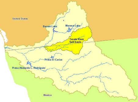
The
Tijuana River Watershed (TRW) straddles the U.S./Mexican Border (Figure
1) and encompasses the Tecate-Cottonwood sub-basin. The Rio Alamar (Alamar
River) Corridor drains the upper watershed (Cottonwood and Campo Creeks in the
U.S. and Tecate Creek in Mexico) in the northern third of the Tijuana River
Basin. Flooding along the Tijuana
River and Rio Alamar is responsible for property damage and human death during
flood events, as well as severe sedimentation that damages the Tijuana Estuary,
which is the last fully functioning wetland remaining in Southern California.
Figure
1. Map of the Tijuana River Watershed
The
Tecate-Cottonwood sub-basin encompasses 620 square kilometers, including the
Campo Indian Reservation on the U.S. side and the city of Tecate in Mexico.
The area is characterized by steep hilly terrain, a Mediterranean climate
and is dominated by chaparral and coastal sage scrub, wetlands (vernal pools and
riparian zones) and conifers in the mountains.
The temperature ranges between 8 and 18 degrees Celsius and precipitation
ranges from 150 to 650 mm per year (Wright 1999).
The sub-basin is a predominantly rural area, which in 1998 was 88%
non-developed. The major land use
categories are agricultural (6.5%) and dispersed residential (3.1%).
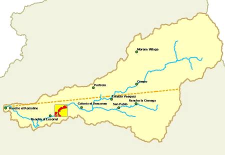
The
website study area is the main stream channel in this basin, the Tecate River,
which is also referred to as the Rio Tecate or Tecate Creek.
The Tecate River drains a large area of 39,660 hectares (Figure 2).
Discharge from the Tecate Municipal Sewage Treatment Plant and the Tecate
Brewery feed into the Tecate Creek (Gersberg 1996).
Figure
2. Map of the Tecate-Cottonwood Sub-basin and Study Area
Economic growth in the region over the last 20 years has caused significant impacts on the watershed. Maquiladoras (companies who take advantage of Mexico’s lax environmental and labor laws) offer salaries that are higher than the minimum national wage, drawing migrants from other parts of Mexico. Migration has resulted in a population explosion (see table 1) of unplanned squatter settlements without access to water supply or wastewater systems (Ganster 1996).
Table 1. Population and Growth Rates for 4 Regional Cities
|
City |
Population 1990 |
Population 2001 |
Average Annual Growth Rate |
|
Tijuana |
689,000 |
1,149,00 |
4.9 |
|
Tecate |
40,000 |
55,000 |
4.2 |
|
Rosarito |
23,000 |
44,000 |
5.4 |
|
San Diego |
1,110,000 |
1,241,600 |
1.2 |
The
urgency of these regional issues is caused by Tijuana’s eastward expansion
that threatens to reach Tecate between the years 2007 to 2012.
Estimates are that the population in this area is likely to double in the
next 20 years. However, while
demand in the region is rising, water supplies remain steady.
With an average rainfall of only 10 inches (Wakida 1998), there is more
evapotranspiration then precipitation. Imported
water from the Colorado River currently serves 85-90% of the area.
However, due to dams and diversions, the flow from the Colorado is
inconsistent and has decreased dramatically between 1935 and 1993, with little
to no water reaching the outlet in non-flood years (Glenn 1995).
It is apparent that the current practices are not sustainable.
Increased
urbanization and encroachment of humans into the flood zone of the Tecate River
has resulted in the need to modify the banks with rocks and other items to
prevent flooding. However, channelization (concrete surfaces) stops
infiltration into the soil and increases the rate at which pollutants reach
rivers and streams. Storm water
runoff appears to be the major source of heavy metals in the Tijuana Estuary,
with zinc found in high concentrations (EPA 2000).
Studies
of the Tecate River reveal poor water quality.
In 2001, significant amounts of cadmium, chromium, copper and nickel were
detected downstream from the city’s wastewater plant. Studies by SDSU also
document high levels of metals and fecal waste into the Tecate Creek, and stress
the need for a comprehensive wastewater and storm water management plan (Gersberg
1996).
According
to the Environmental Protection Agency (EPA), the most critical factor for the
Tecate-Cottonwood sub-basin on the U.S. side is the lost of biodiversity (EPA
2000). Biodiversity enhances
ecosystem functioning such as nutrient cycling and fixing.
Other ecosystem benefits include water and air purification and soil
generation. High biological diversity is important both for ecosystem health and
for resistance/recovery from disasters (Swanson 1992).
It is evident from the literature review that there are a number of
critical issues that must be considered as management decisions are made
regarding the Tecate River. As
previously indicated, the internet can serve as a mechanism whereby information
on these issues can be communicated to the public, as well as to managers and
urban planners. In addition,
interactive maps aid in visualization of the various alternatives.
Therefore, our website was developed in order to provide these services.
METHODS AND RESULTS
Website
Frontpage was used to design the
website. Since a wide audience of
Mexican and American urban planners, residents and other interested parties are
the targeted users of this site, an effort was made to keep a relatively simple
design that would be easy to navigate and understand. Therefore, the information is provided in a concise bulleted
format, with easy access to additional information for those who want it.
An attempt was made to provide as much information as possible in both
English and Spanish, however time constraints prevented us from being able to
translate all of the text.
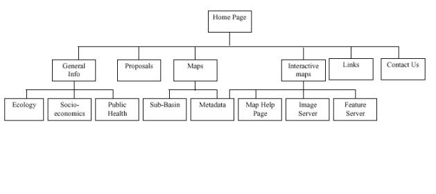
The website hierarchy is included as Figure 3.
It has a broad shallow design, with links to each of the main pages from
the home page. Navigation link bars were provided at the top of each page so
that users could easily navigate back and forth to various pages within the
site. An attempt was also made to
fit each page onto one screen so that viewers did not have to scroll down to see
all of the information, however we were not able to accomplish this.
Figure
3. Website Organization
The home page consists of our mission statement and some pictures of
Tecate to allow viewers to familiarize themselves with the river site, the
general area and some of the landmarks. Each
of the pictures on the home page is a thumbnail that displays the name of the
feature when the cursor is moved over it, and users are able to click on the
thumbnail to see a larger image. The
general information page provides a regional map of the area and brief
information on the physical characteristics of the study area in addition to
links to the socioeconomic, public health and ecology pages.
Each of these pages provides some brief information on the most critical
issues that were identified in the literature.
The ecology page mainly focuses on the loss of biodiversity in the region
and includes a table of vegetation changes.
The socioeconomic page includes population and economic growth
information. The public health page
includes a table of potential river pollutants, their sources and the health
effects associated with exposure to them. This
page also includes other information on both surface and groundwater quality in
the region.
The static map page includes a map of the Tijuana River Watershed region,
with the study area hotlinked to the sub-basin map page.
The user is able to click on this area and “zoom in” to the sub-basin
page, which includes location and relief maps of the Tecate-Cottonwood sub-basin
and study site, each with an outlined area that is hotlinked to the interactive
map page. The interactive map page is where users are able to choose between the
feature server and image server, depending upon the level of interaction that
they want to, or are able to perform. “Map Help” pages are provided for each
type of server. These pages provide
some basic information to help users navigate the features of the interactive
maps. Both types of maps (image and
feature server) are offered so that a wider range of users can use the services.
In addition, a metadata page is included.
Since the authors created the data for the interactive maps from an
aerial photograph, metadata is provided. The
user can access the metadata page from either the interactive map page, or from
the map of the Tijuana River Watershed. The
interactive maps are discussed in more detail below.
Another
feature of the website is the Links page, where the user can find more
information on the Tijuana River Watershed, hydrology studies, other river
parks, water quality studies and reports, tourist information for Tecate, and
information on the groups involved with the Tecate River park proposal.
The links list is not particularly long, but includes the most complete
and accurate sources of information that we could find.
The final feature of the website is the “Contact Us” page.
Since this website is intended to serve as a communication mechanism
between project proponents and interested parties, this page offers a way for
users to provide their comments, and for the river park planners to receive
feedback on the plans and website information.
Although this page is not functioning correctly when the provided form is
filled in and sent, there is an email address provided for those that wish to
respond.
Static
Maps
All static maps were created in ArcGIS
(8.1, ESRI, Redlands, CA 2001) and exported as JPEG files for display in
FrontPage. All coverages and
shapefiles of the Tijuana River Watershed, the Tecate-Cottonwood Sub-basin and
San Diego County were obtained from the
Center for Earth Systems Analysis Research (CESAR) at
SDSU. The aerial photograph and
layers for the study area were obtained as described below.
Interactive Maps
The primary source was a
geo-rectified NOAA aerial photograph that was taken of the Tecate River region
in 2000. The photograph was
supplied to us for the purpose of constructing a web-based interactive map by
CESAR at SDSU, after being processed there by Dave McKinsey.
New vector coverages with the same coordinate system and projection as the aerial photograph were created in Arc Catalog (ArcGIS v.8.1, ESRI, Redlands, CA, 2001). Once the new coverages had been created, they were opened in Arc Map, where new features could be digitized using the editor tool. Arc (line) features were created for the river, roads and possible channelization. Polygon features were created to represent the study area, neighborhoods, commercial areas, parks, recreation, industrial zones, well locations and our proposed riverpark site.
There were four additional digital vector layers obtained from CESAR that were of the Tecate-Cottonwood sub-basin: the basin boundary, the sub-basin rivers, soils and vegetation. These layers were digitized in 1995, as part of a different project by individuals at SDSU. The sub-basin boundary and river layers were left unaltered for internet display. The soils and vegetation layers were clipped to the study area using the geoprocessing wizard in ArcGIS. Though created in two different time periods, there was good agreement between the locations of features in the sub-basin layers and those in the 2000 image.
Because ArcIMS (ESRI, Redlands, CA, 1999), the final destination of the maps, does not support coverages as a file type, the new layers were opened in ArcView (v3.2, ESRI, Redlands, CA 2000) and converted to shapefiles. Once in shapefile format, new fields were added to the attribute tables to display information in both English and Spanish.
The full image was over 1.5 gigabytes in size: too large to be supported by the ArcIMS server. To provide a way for the image to be included as a layer in the interactive map, it was necessary to have it cropped to the area of the study site and decompressed to a much poorer resolution than the original image. Harry Johnson at CESAR completed this portion of the image processing using ERDAS Imagine software (v.8.4, ERDAS, Atlanta, GA, 2001). Both the modified image and the shapefiles were stored on a local network drive.
ArcIMS was the internet mapping program used for the site. We created two maps: an HTML based image server that could support the image file, be accessed by anyone with an internet connection, but with limited customization functions; and a JAVA based feature server, without the image that would have greater functionality for the more advanced user. Both maps were created and customized to select the best display properties for each layer using the Author component of ArcIMS.
Once the maps were constructed, our course instructor utilized the IMS Administrator to designate the location and name of the new maps on the server and the location of the shapefiles from which the maps were created. The next step was customizing the look of the browsers and choosing the components we wanted our viewers to have. This was done with the Designer component of ArcIMS. Our design choices were based, again, on the functionality we wanted the two interactive maps to have. The image server was intended to be display oriented; we wanted the user to be able to click layers on and off and perform simple queries to find out where features are and what they are called, but not a lot more than that. For the feature server, we focused on function, keeping the display more simple; we wanted the user to “play” with the map and tryout different options, create map notes and edit the look of the map to suit their own purposes.
Invariably, the look of the map on the desktop, in the design phase was
different from the finished product on the server.
Changes to the appearance were easily made by modifying the axl file in
notepad and republishing the map or by opening the map in Author and adjusting
the feature properties to make a more aesthetic map that could be re-sent to the
server. Both maps were modified
multiple times in this manner with varying degrees of success.
The current “final maps” are published on the site.
DISCUSSION
Although our website provides good
background information and maps of the area, there are a number of other
resources that could potentially be added in the future.
For instance, daily stream flow gauges on the Cottonwood and Campo Creeks
(1936 to present) are available online at the United State Geological Survey (USGS)
website (USGS 2001). These data can
be used to determine maximum, minimum and average flows, and to estimate extreme
flood or minimum flow events. In the future, perhaps this information could be combined
with water quality data from other studies to model water quality in the region
(Gersberg 1997). It could also be
used to help design future water sampling points and aid in temporal designs to
monitor important flow events (Heathcote 1998). The ideal would be to link this
flow data into a user-friendly viewer so that real-time modeling analyses could
be performed.
A digital elevation model (DEM) for the sub-basin is available for
calculating stream direction, flow accumulation, drainage density, slope and
relief ratio. When this is combined
with soil, vegetation, land-use and other coverages, erosion hazard maps and
flood hazard maps can be created. Currently,
it is only possible for users to view the DEM, however future access to these
combined GIS layers may allow users to perform modeling functions.
In
order to provide a complete and full-service urban planning tool, additional GIS
layers still need to be created. Aquifers,
or groundwater supplies that are concentrated in Tecate need to be mapped and
the water quality assessed for potential storage purposes.
This would be a critical tool for planners who are concerned about water
quality and quantity. In addition,
lists of potentially affected species have been created (MSCP 1996; Cooperation
2000; Delgadillo 2000), however maps of their habitats are still needed so that
multi-species modeling can begin. Finally,
although difficult to produce, carbon stores and nitrogen paths could be modeled
and this information provided in order to improve natural resource planning.
There
are currently several other River Park sites in the internet, including San
Dieguito River Park in San Diego at http://www.sdrp.org/,
Guadalupe River Park in Sacramento at http://grpg.org/,
Cloverdale River Park in Cloverdale, CA at http://www.cloverdale.net/visit/riverpar.htm
and the James River Park System in Richmond, VA at http://www.ci.richmond.va.us/department/Parks_Rec/james.asp.
These are all primarily information–only sites that do not include
interactive mapping tools. Our
Tecate website represents an effort to go one step beyond, by providing a
mechanism for users to ask "what if" questions about alternative
strategies and visualize the options.
REFERENCES
Cooperation,
C. f. E. (2000). Biodiversity Conservation: Concservation of Migratory and
Transboundary Species. Montreal, Canada: 79.
Delgadillo,
J. (2000). “Floristica y ecologia del norte de Baja California.” Divulgare
29: 46-63.
EPA (2000)Cottonwood-Tijuana Watershed Profile. www.epa.gov/surf3/hucs/18070305/index.html.
EPA
(2000). Draft EIS Tecate, BC water and wastewater improvement project.
EPA: 31.
EPA
(2000). Surf your watershed website.
Ganster,
P. (1996). “Environmental Issues of the California-Baja California Border
Region.” Border Environment Reports June(1):
1-14.
Gersberg,
R. M. (1996). “Monitoring and Modeling of Water Quality in the Tijuana River
Watershed.” Final Report SCERP Project WQ PP96II-10: 355-369.
Gersberg,
R. M. B., Chris (1997). “Predictive modeling of the interactions between land
use and storm water quality in the Tijuana River Watershed.” SCERP Project
W97-2: 16.
Glenn,
E. P. L., Christopher; Felger, Richard; Zengel, Scott (1995). “Effects of
water management on the wetlands of the Colorado River Delta, Mexico.” Conservation
Biology 10(4): 1175-1186.
Heathcote,
I. W. (1998). Integrated Watershed Management:Principles and Practice.
New York, John Wildey & Sons, Inc.
IUCN
(1997)United Nations List of Protected Areas. www.unep-wcmc.org/cgi-gin.pa_un97.
Last Update. Date
Michel,
S. (2001) "The Alamar River Corridor:
An Irban River Park Oasis in Tijuana, Baja California, Mexico" Borderlink
2000 Final Report
Michel,
S. (2001). “Defining hydrocommons governance along the border of the
Californias: a case study of transbasin
diversions and water quality in the Tijuana-San Diego Metropolitan Region.” Natural
Resources Journal.
Michel,
S. and C. Graizbord (2002) "Urban Rivers in Tecate and Tijuana:
Strategies for Sustainable Cities" Unpublished draft report by the
Institute for Regional Studies of
the Californias, SDSU.
MSCP
(1996). MSCP Plan. San Diego.
Perry,
A. W., Kate (2001)TWR Online Planning Atlas. http://map.sdsu.edu/group2001/group5/home.htm.
Last Update. Date
Service,
N. P. www.nps.org. Last Update. Date
Swanson,
F. J. N., R.P; Grant, G.E. (1992). Some Emerging Issues in Watershed
Management, Springer.
USFWS
(2000). Finding of no significant impact (FNSI) for water and wasterwater
infrastucture improvements fo Tecate, BC Mexico. San Francisco, EPA:
2.
USGS
(2001)Stream gauge data. www.usgs.gov. Last Update. Date
Wakida,
F. R., Karen (1998). The Tijuana river basin: basic environmental and
soicioeconomic data. San Diego, Institute for Regional Studies of the
Californias: 104.
Wilkens,
M. (2001). pers. comm. CUNA. Ensenada.
Wright,
R. (1999) TWR. www.typhoon.sdsu.edu/tjwater/.
Wright,
R. R., Kathryn; Winckell, Alain (1995). “Identifying priorities for a GIS for
the Tijuana River Watershed.”: 93.
.
Appendix A.
Pros and Cons of Various Land-Use Options
|
Alternative |
PROS
|
CONS |
|
River Park |
·1
Long-term planning for future ·2
Good for flood control ·3
Natural filtering of pollutants with vegetation ·4
Increased quality of life and green areas for residents ·5
Increased property values (see Mission Valley, San Diego)
·6
Increased functioning of Tecate-Cottonwood watershed and decreased
dependence on costly imported water ·7
Erosion control with natural vegetation decreases sedimentation downstream
and in the TJ Estuary ·8
Decreased cost to taxpayers of pollution/flood cleanups ·9 Shade
decreases evaporation of surface water ·10
Slower drainage to the stream channel means more water quantity ·11 Vegetation improves air quality
·12 Habitat corridor for terrestrial and aquatic species ·13
More wetlands (worth $6600/acre†) ·14
Recreational and educational Opportunities
·15
Increase in tourism ·16 Potentially connected to Tijuana River Parks Crest to Coast (i.e.
San Dieguito River Park) ·17
Complies with Mexico’s Natural Water Commisson watershed council law and
supported by U.S. (i.e. Border Environmental Cooperation Commission BECC) |
·1
Short-term flood problems while building park ·2
Costs of rezoning the area ·3
Less commercial development along river banks ·4
Costs of relocating current residents ·5 Costs
of planting native vegetation and building recreational facilities ·6 Costs
of creating laws for river park use ·7
Enforcement of new laws ·8 Short-term
benefits are easier to sell to public and government |
|
Channelize Channelize (continued) |
·1
Short-term flood control ·2
More land for commercial development on banks |
·1
Higher costs of project ·2
Increase in severity of floods (see Tijuana and Los Angeles††) ·3 Increased in cost to
taxpayers of emergency flood and pollutant cleanups
·4
Concrete bottom minimizes exchange between river and groundwater ·5 Decreased shade allow evaporation ·6
Pollutants cannot be filtered by riparian vegetation ·7
Sedimentation of downstream areas and Estuary ·8
Increased dependence of Colorado River supply ·9
Decreased ecosystem functioning and associated economic benefits (local
water supply, clean air) ·10 Division of city life with steep concrete channels |
|
No Action |
·1 No change in costs to government and taxpayers
|
·1 Continued costs of emergency cleanups after floods and pollution
spills ·2 Continued decrease in water supply ·3 Continued decrease in ecosystem functioning
·4 Continued encroachment by humans on habitats
·5 Continued sand mining on banks
·6 Continued nitrogen input by cattle grazing on banks
·7 Continued unmitigated pollution by industry |
† Husted, Rachel. 1997. Wetlands for Clean Water. How Wetlands
Protect Rivers, Lakes and Coastal Waters from Pollution. Washington, D.C.: Clean
Water Network and Natural Resources Defense Council.
††
Dallman, Suzanne, and Piechota, Tom. 2000. Storm
Water: Asset not Liability. Los Angeles: The Los Angeles and San Gabriel Rivers
Watershed Council.