GEO 596 Internet Mapping and Distributed GIServices
![]()
![]()
Unit 14 (Session One):
![]()
May 3 (Tuesday) from 1:00pm - 3:50pm. (Required for everyone - signup sheet).
Each Group has 17 minutes presentation (including Video presentation), 3 minutes Q&A
Group Project Presentation:
Group Project Progress Report:
Group 1: The SD Camping Guide
Team members: Jesus A. Tamayo, Caleb Bombaci, Richard Caslow.
Group 2: Pups Who Brunch - San Diego
Team member: Melanie Lopez (Coordinator), Haihong Huang, Fali Field
All late lab exercises and the FINAL PROJECT PAPERS need be submitted before May 10 by EMAIL to mtsou@mail.sdsu.edu .
![]()
![]()
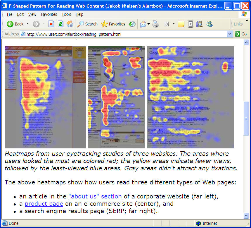
http://www.useit.com/alertbox/reading_pattern.html
![]()
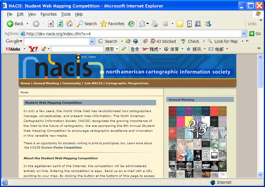
http://dev.nacis.org/index.cfm?x=4
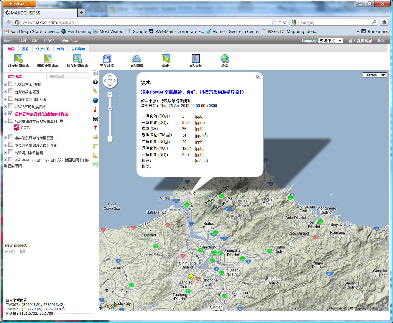
Taiwan's Sensor Web Mapping Applications:
http://www.makoci.com/isdss.do
![]()
The Future of Geographic Information Services
To provide on-line geographic information services effectively in an open, distributed network environment, a new paradigm of GIS architecture must be established and adopted. The architecture of distributed GIServices should be platform-independent and application-independent. It should provide flexible and distributed geographic information services on the Internet, without the constraints of computer hardware and operating systems. The following figure shows three alternatives for GIS architecture.
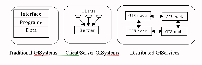
Three alternatives for GIS architecture.
Traditional GISystems are closed, centralized systems, incorporating interfaces, programs and data. Each system is platform-dependent and application-dependent. Migrating traditional GISystems into different operating systems or platforms is difficult. Different GIS applications may require different GIS packages and architecture design. Every element is embedded inside traditional GISystems and can not be separated from the rest of the architecture.
Client/Server GISystems are based on generic client/server architecture in network design. The client-side components are separated from server-side components (databases and programs). Client/Server architecture allows distributed clients to access a server remotely by using distributed computing techniques, such as Remote Procedure Calls (RPC), or by using database connectivity techniques, such as Open Database Connectivity (ODBC). The client-side components are usually platform-independent, requiring only an Internet browser to run. However, each client component can access only one specified server at one time. The software components on client machines and server machines are different and not interchangeable. Different geographic information servers come with different client-server connection frameworks, which can not be shared.
Distributed GIServices (Peer-to-Peer GIS nodes) are built upon a more advanced architecture. The most significant difference is the adoption of distributed component technology, which can access and interact with multiple and heterogeneous systems and platforms, without the constraints of traditional client/server relationships. Under a distributed GIService architecture, there is no difference between a client and a server. Every GIS node embeds GIS programs and geodata, and can become a client or a server based on the task at hand. A client is defined as the requester of a service in a network. A server provides a service. A distributed GIService architecture permits dynamic combinations and linkages of geodata objects and GIS programs via networking.
Related Links:
|
|
What is P2P ... and What isn't ? by Clay Shirky 11/24/2000 http://www.openp2p.com/pub/a/p2p/2000/11/24/shirky1-whatisp2p.html |
|
|
What Can P2P Do for B2B? By Mark Merkow, CCP, CISSP http://ecommerce.internet.com/outlook/article/0%2C1467%2C7761_486031%2C00.html |
|
|
http://compnetworking.miningco.com/compute/compnetworking/cs/peertopeer/ |
|
|
CNN - TIME: Napster the Revolution http://www.cnn.com/ALLPOLITICS/time/2000/10/02/revolution.html |
Discussion:
What is Peer-to-Peer? What kinds of GIServices can utilize this network model?
What are the similarities and differences between the Napster.COM and "Data Clearinghouse"?
BitTorrent
http://en.wikipedia.org/wiki/BitTorrent
(This picture is from http://en.wikipedia.org/wiki/BitTorrent )
"In this animation, the coloured bars beneath all of the clients represent individual pieces of the file. After the initial pieces transfer from the seed, the pieces are individually transferred from client to client. The original seeder only needs to send out one copy of the file for all the clients to receive a copy." (cited from http://en.wikipedia.org/wiki/BitTorrent )
![]()
The Power of Networking
![]()
Value-added Information Processes
One implication of distributed GIServices is to add value to information processes. A value-added information process is an information service that uses available facilities to add additional services and in doing so, increases the total value of services. By combining distributed GIS components and geodata objects on the Internet, GIServices will be able to provide more types of services and generate added worth to traditional GISystems. Two types of value-added processes could work this way.
First, distributed GIServices can generate new services and add new values by combining different GIS components. Traditional GISystems have limited GIS functions inside the closed system framework. The value (X1) generated from a single GISystem is constrained by system functions and closed architecture. With the advantages of LEGO-like GIS components, distributed GIServices can combine different functions/components to combine values (X1 + X2 + X3) under the dynamic architecture.
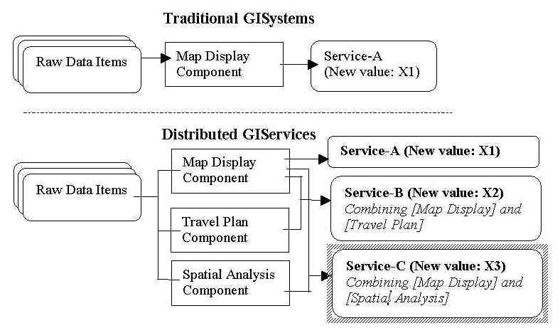
The new values generated from the usage of GIS components.
The second type of value-added process is that multiple GIS projects can access a single GIS database remotely via the network, adding value to it. Traditional GISystems lack remote database access capabilities and require manual data conversion procedures. By adopting standardized communication protocols and agent-based data conversion approaches, distributed GIServices can facilitate the reuse of databases and reduce the cost of new data generations for GIS projects. For example, a completed Boulder City GIS database can be used for three different projects, such as Wal-Mart site selection, urban zoning, and the school bus routing analysis. The total value of Boulder City database becomes more valuable than if used by a single application. The more a database is used, the more valuable that database becomes. In other words, the distributed database access and management will encourage reuse of existing geodata objects and prevent redundancy of data reproduction. The cost of data production takes up 70% of the total application cost; this cut in data production can also save labor and application program money and add value to GIS applications.
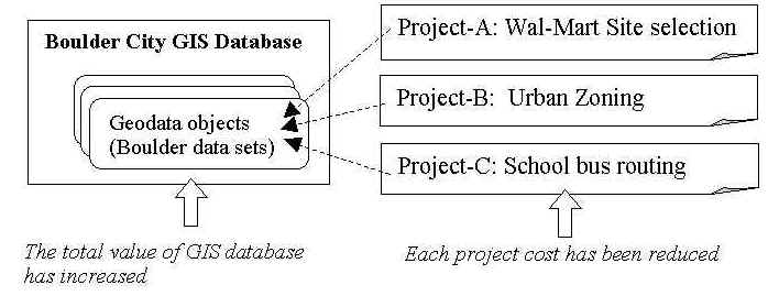
The value-added process in distributed databases.
In general, the life cycle of information value for distributed GIServices is quite different from traditional GISystems. The following figure illustrates the life cycle of information value in traditional GISystems.
The life cycle of information value in traditional GISystems.
(Costs are assumed to account for inflation over time.)
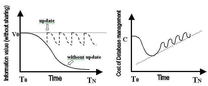
The initial value of information is fixed (V0) in traditional GISystems. If information items are not updated, the value will decrease gradually over time due to the decrease in data quality, currentness, and the increase in data uncertainty. Therefore, GIS database managers have to update information items frequently in order to keep the information value relatively stable.
The cost of database management in traditional GISystems is also illustrated in the previous figure. The initial cost carries a significant startup expense due to the creation of new databases. The subsequent operation cost will be lower than the initial cost because the GIS database has been established, but the cost will increase again concurrently with data update operations.
The following figure indicates a different life cycle of information value in distributed GIServices. The value of information items will not decrease but increase gradually over time by sharing information with others.
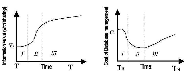
The life cycle of information value in distributed GIServices.
(Costs are assumed to account for inflation over time.)
There are three phases in the life cycle of information value in distributed GIServices. The first phase (I) is the initial stage of data sharing and exchange. The number of users is limited at this time because not many users are aware that the information item is available on-line. As more people become aware, data will be used in multiple applications (phase II), and the value of information will increase during this time. In phase III, information sharing will decrease because data become out of date and used only for specialized tasks (historical). The growth of information value will slow down. When the factor of information uncertainty becomes higher than the factor of corrected errors, the growth of information value will drop or perhaps stabilize, unless the data retain historical value.
The cost of database management in distributed GIServices also has three stages. The initial cost requires a significant startup expense in the first phase (I), same as the traditional databases. The subsequent operation cost in phase II will be much lower than that of the traditional databases because as more people use the information, they will report errors or incompleteness to help data providers correct errors and improve the data quality. When the number of users decreases in phase III, the cost of GIS database management will increase again concurrently with data update operations.
There are three phases similar to the life cycle of information value. The first phase (I) is the initial data sharing and exchange. Few user feedbacks and corrections happen at this stage and the information uncertainty increases gradually because of temporal currentness. In phase II, the number of corrected errors (Cn) will increase along with the popularity of the information items and allow the original data providers to improve the data quality. The feedback from users will slow down the growth of information uncertainty. Eventually, the information uncertainty (Un) will rise again over time because of temporal currentness and the decrease of corrected errors from users (phase III).
To summarize, distributing GIServices can add value to information. Distributed GIServices can generate new information value by sharing geodata objects, by combining GIS components, and by exchanging knowledge and metadata between the members of the GIS community. Moreover, distributed database access and maintenance can reduce the cost of database management. In short, distributed GIServices will encourage collaborative error checking processes and improve the data quality by user feedback and update.
In the computer industry, an example of value-added information processes can be found in the development of the Linux operating system (Welsh et. al., 1999). Because of the open environment provided by the Linux, the feedback from a large number of users improved the kernel of Linux, making the operating system more stable and therefore, more useful. By releasing the power of autocratic control, the developers of Linux get thousands of free software engineers and programmers working together via the Internet to improve this operating system. Thousands of Linux applications are being developed by software companies, which will add value to the Linux operating system and to software companies. Distributed GIServices borrow the development strategy from the Linux example by releasing the control of data objects and GIS components. The sharing of data sets and programs for distributed GIServices will encourage the reuse of these computing resources, improve data quality and reduce uncertainty, and reduce the cost of data production and GIS programming.
The Exponential Growth of GIS Network Values
The second implication of distributed GIServices is the exponential growth of GIS network values. As mentioned earlier, the increasing value of distributed GIServices is derived from sharing and exchanging information and programs. The basic requirement for sharing is the establishment of network connections for GIServices. If a network builds more connections, the more sharing and exchanging events may happen, and then more value would be generated from the network.
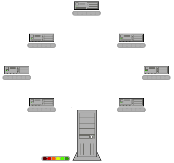
Kelly (1998: 23) states that "mathematics says the sum of value of a network increases as the square of the number of members. In other words, as the number of nodes in a network increases arithmetically, the value of the network increases exponentially." According to his statements, a network value will be increased according to the growth of nodes and links in a distributed GIServices network. The mathematical results are shown in the following Figure.
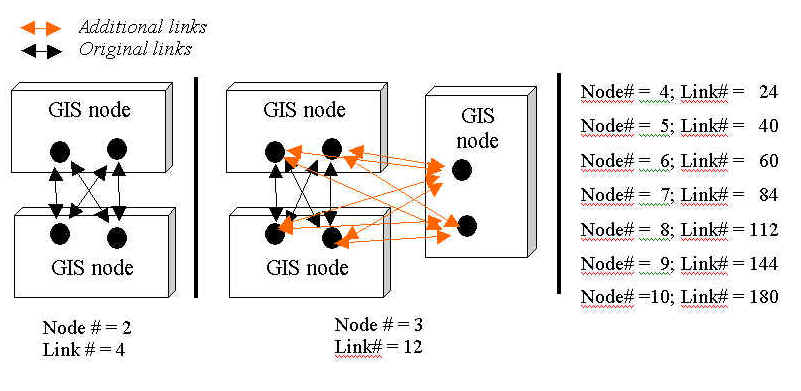
The exponential growth of distributed GIServices network.
This figure illustrates the growth of simplified GIS nodes and the network connections in distributed GIServices. In this figure, each GIS node is simplified as one grouped geodata object and one GIS component (two dots inside each box). In the real world, the arrangement of geodata and components may be more complicated in distributed network environments. If we only consider the simplified situation, the growth of network connections comes along with the increasing number of GIS nodes. The number of GIS nodes increases arithmetically from 1, 2, 3 to 10, and the number of network connections increases exponentially from 4, 12, 23, to 180. Along with the exponential growth of connections, the values of the whole network will also grow exponentially.
This example shows the unique feature of network development. It also illustrates that the power of network comes with the increasing number of members in the network. In order to know how network connections facilitate the increase of the total value of network, the following discussion will introduce three scenarios and put them together inside an integrated GIServices network. By integrating computer resources, geodata objects, and GIS components in all three scenarios, the three GIS users (Mike, Dick, and Eva) can generate more valuable services for themselves. It can also demonstrate the exponential growth of network values. The following paragraphs will describe briefly the original design of the three scenarios and illustrate their advantages and new values if we combine them together in an integrated GIService network.
The first scenario illustrates that Mike, a GIS user, plans a trip from Boulder, Colorado to Utah’s Arches National Park during the spring break. He acquires related map information (highways, park trails, city roads, and hotel locations) from the Internet, prints out his travel maps, and makes an on-line hotel reservation in Moab, with the help of a hotel reservation agent. In the second scenario, Dick wants to locate a site for a new Wal-Mart store in Boulder. He obtains related map information from the data server in Boulder’ Planning and Police department and performs a GIS overlay analysis for his task. He also downloads a GIS component called [Shape Fitting Analysis] to help him finish the location analysis more efficiently. The third scenario indicates that Eva, a homemaker, wants to visit her friend in Superior, Colorado. She uses her Palm-size PC, wireless phone and the Global Positioning System (GPS) device in her car to navigate to her friend’s house. The Colorado data sets in her Palm-size PC has been updated in real-time via her cellular phone from the GPS-data.COM server. She also uses the same service to choose a Chinese restaurant close to her friend’s house.
By integrating all computer resources, geodata objects, GIS components, users in the three scenarios described above, the new GIService framework will be able to provide many new services and add new value for the three GIS users (Figure 6-7).
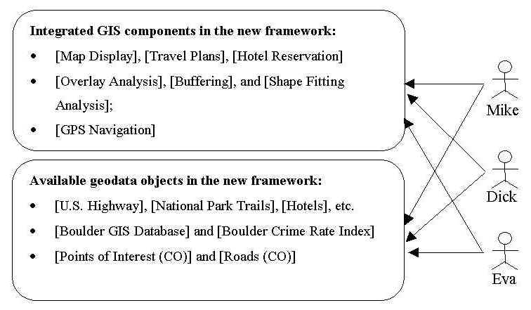
The integrated GIService network for different users.
The following is a list of examples of possible new services in the integrated GIService framework. GIS users can utilize the integrated computer resources and accomplish different GIS tasks according to their needs.
These six examples mentioned above are some representative applications and projects which can benefit from combining the three scenarios. Under an integrated GIServices framework, both geospatial data objects and GIS programs are shared and can provide more flexible information services for different users. In fact, dozens of new services can be generated from the integrated network of the three scenarios. In short, the exponential growth of network values is a very attractive advantage for the deployment of distributed GIServices network. The exponential growth will attract more people and projects to participate in the network with a distributed, dynamic architecture. As more people join in the GIS network, more information and programs will be available for sharing and exchanging, and thus the GIS network will become more valuable. As the GIS network becomes more valuable, it will attract more people to join in. Therefore, the positive reinforcement can ensure sustainable growth of distributed GIServices and the popular use of geographic information in the future.
Related Links and Books:
|
|
Out of Control : The Rise of Neo-Biological Civilization by Kevin Kelly (1995) |
|
|
New Rules for the New Economy: 10 Radical Strategies for a Connected World by Kevin Kelly (1999) http://www.amazon.com/exec/obidos/ASIN/0670881112/inktomicom-20/104-1587597-6343161 |
|
|
Digital Darwinism : 7 Breakthrough Business Strategies for Surviving in the Cutthroat Web Economy by Evan I. Schwartz (1999) |
|
|
Information Rules : A Strategic Guide to the Network Economy by Carl Shapiro, Hal R. Varian (1998) |
| Ten Rules for the New Economy |
| Embrace the Swarm. A bit of intelligence in a lot of places—for example, a microchip on every can of soup in a grocery store—is better than a lot of intelligence in a single place. |
| Increase Returns. The value of a network like the Internet increases explosively the more people you add to it. |
| Plenitude, not scarcity, is key. The more people who use a technology, such as fax machines or automated teller machines, the more valuable it is. “Avoid proprietary systems,” Kelly writes, referring to online services such as America Online. “Sooner or later closed systems have to open up, or die.” |
| Follow the Free. Prices in today’s economy fall inexorably as products flood the market. Don’t fight it, because demand will rise faster than prices will fall. The only thing that is scarce is human attention. |
| Feed the Web first. People are loyal not to a company, but to a network, so spend your time setting standards and building on the ones that people have already accepted. |
| Let go at the top. To go from success to greater success, organizations must devolve—“do business less efficiently, with less perfection, relative to its current niche,” writes Kelly. That means “creative destruction,” or walking away from successful business practices. |
| Move from places to spaces. The economy is moving from a physically defined world to an electronic one, which leads to the rise of a new set of intermediaries and communities based on special interests. “The Net shifts from mass media to mess media,” Kelly writes. |
| No harmony means all flux. If a company settles into harmony and equilibrium, it will eventually stagnate and die. The key to robust growth for all industries is to imitate the history of the movie business, which transformed from the Hollywood studio system to a collection of freelancers. |
| Relationship tech. The goal of the network economy is to amplify relationships. Companies should go from creating what the customer wants, to remembering it, to anticipating it, to changing it. Encouraging customers to talk to one another and form affinity groups will make them smarter and more loyal. |
| Put opportunities before efficiencies. Don’t solve problems, pursue opportunities. Waste is a beneficial byproduct of creativity. If you want to make people more productive, give their work to a machine. |
Source: New Rules for the New Economy: 10 Radical Strategies for a Connected World by Kevin Kelly (1999).
DISCUSSION:
The Progress of Network Technology is an "Evolution" or a "Revolution"?
Who can control the NET? Government? Public? or Private Sector?
Two alternative path (Open Standard vs. Private Industry)
![]()
Conclusion
In general, the deployment of GIServices will facilitate scientific data management in geographic domain. The scientific community, through government science agencies, professional societies, and the actions of individual scientists, should improve technical organization and management of scientific data (National Research Council, 1998) in the following ways:
a. Work with the information and computer science communities to increase their involvement in scientific information management;
b. Support computer science research in database technology, particularly to strengthen standards for self-describing data representations, efficient storage of large data sets, and integration of standards for configuration management;
c. Improve science education and reward systems in the area of scientific data management; and
d. Encourage the funding of data compilation and evaluation projects, and of data rescue efforts for important data sets in transient or obsolete forms, especially by scientists in developing countries.
(National Research Council, 1998, p 13)
In the Twentieth century, the visible world was re-shaped by the development of engineering technology. People used technology to create skyscrapers, airplanes, space shuttles, water dams, etc.
In the Twenty-first century, the invisible world is going to change by the progress of information technology. The developments of the Internet, wireless phones, biochemistry engineering, DNA-research, e-commerce, virtual reality, and the Web, have already made our lives very different, and will continue to do so. However, when technology is changing the world inside out, one needs to consider whether to use the technology. “The more interconnected a technology is, the more opportunities it spawns for both use and misuse” (Kevin Kelly, 1998, p. 45.). While enjoying the power of network-based GIServices in the Twenty-first century, one may want to ask if technology is being used or misused. This dissertation designed a dynamic framework for the GIS community to adopt new technologies in the future. However, the GIS community will have to ensure that these new technologies will be used appropriately to facilitate research in geography, the growth of GIS industry, and better quality of life for the public.
![]()
References:
Welsh, M., Dalheimer, M. K., Kaufman, L., & Welsh, M. (1999). Running Linux (third edition). Sebastopol, California: O’Reilly & Associates.
Kelly, K. (1998). New Rules for the New Economy: 10 Radical Strategies for a Connected World. New York: Penguin Books.
Holland, J. H. (1998). Emergence: from Chaos to Order. Reading, Massachusetts: Addison-Wesley.
Vckovski, A. (1998). Interoperable and Distributed Processing in GIS. London: Taylor & Francis.
![]()
![]()
![]()
![]()