How GIS can Help us?
Four directions:
Real-time Spatial Support Decision Making Systems (SDSS) (for Incident Commander).
Providing Spatial information for the Public and the Media (evacuation update and traffic update)
Mobile GIS/GPS devices for fire-fighters and fire-equipments to facilitate communications and resource relocation plan.
Mitigation,
Response, and Recovery (short-term recovery and long-term recovery).
The following research notes are created by SDSU Faculty during the 2003 Cedar fire.
What is GIS (Geographic Information Systems)?
Geographic Information Systems (GIS) are technological tools to collect, store, query, analyze, and visualize spatially-associated data and information. Global Positioning Systems (GPS) technology, vehicle navigation technology, online maps like Mapquest and Google Maps, and virtual globe software applications like Google Earth and NASA World Wind are specific applications of GIS technology. Many people are familiar with these cutting-edge applications. However, they might not realize that they are using GIS and related geospatial technologies everyday.
GIS = Spatial Decision Support Systems.
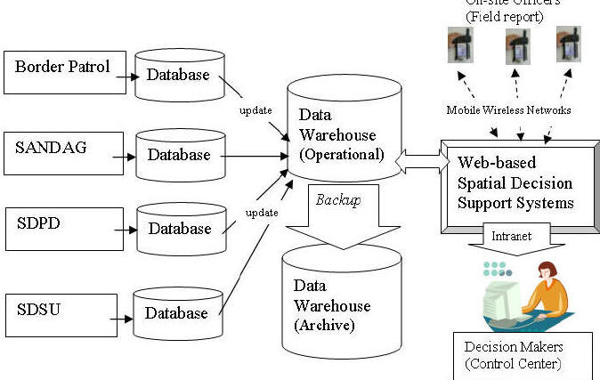
Web-based GIS is a new direction for disaster management and recovery. By utilizing a standardized web browsers, individual participating agencies can implement their own data systems and services while maintaining an aggregated system-wide interoperability through multiple data warehouses and web-based decision support systems (Figure 1). Two data warehouses (one operational and one for emergency backup) should be established to provide the gateway for accessing geo-spatial data and remote sensed imagery for various applications. Each data warehouse will update their data automatically by communicating with each local database server through standardized communication protocol (Z39.50, TCP/IP, and HTTP) and OpenGIS catalog interface. The Web-based Spatial Decision Support Systems (SDSS) will provide on-line mapping functions and the display of remotely sensed data. The web-based SDSS can used by decision makers and spatial analysts in command and control centers to collect and process information via a secure intranet or encrypted mobile wireless networks, to make decisions and initiate responses to field locations and on-site officers.
Figure 1. Interoperable database framework for web-based spatial decision support systems.
Mobile GIS.
Mobile GIS is another promising direction for disaster management. The mobile devices (PDA, cellular phones, PocketPC, etc) can have the integrated capabilities of GPS, GIS, and remote sensing. Web-based mapping facilities can be integrated with wireless mobile devices. Currently ESRI’s ArcPAD and ArcGIS mobile is the pocket-size GIS software which can be used in mobile GIS research. Also, Microsoft provides several free development tools for mobile and embedded applications under their .NET framework, such as the Microsoft Mobile Internet Toolkit (MMIT). MMIT adopted Wireless Markup Languages and compact HTML (cHTML) which can be applied for mobile devices.
The following figure
illustrates a possible working example of one such mobile GIS solution. In this
example, an Internet map server is installed on a notebook computer with
wireless access port. The notebook and wireless access port will be placed
inside a vehicle to provide power for wireless communication. Fire fighters can
use Pocket PC’s with GPS and a wireless card to access large remote-sensing
imagery and GIS data from the server via Wi-Fi communication channel. They
can also digitize real-time fire perimeters on their mobile GIS devices and send
the results back to the command center via wireless communication. The whole
system is mobile and suitable for various emergency response and recovery tasks.
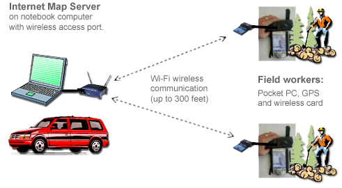
Figure 2. Wireless Local Network Solution for Mobile GIS
Charlie Adler: Utilize real-time "weather bug" information to create a fire model by connecting hundreds of mini-weather stations information together. (Contact "Charlie Adler" <adlercharlie@gmail.com> for more explanation.)
Vegetation: Converted to point data from SanGIS polygons in order to view attribute table in GE
Wind: Weatherbug.com, Multi-layer point data in near real-time; other layers available (see attached)
Both layers created by adlercharlie@gmail.com October 26, 2007.
For more
information regarding the GIS technology, please contact
our department
chair, Dr. Serge Rey
![]() .
.